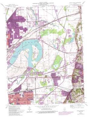
Monks Mound Topo Map Illinois
To zoom in, hover over the map of Monks Mound
USGS Topo Quad 38090f1 - 1:24,000 scale
| Topo Map Name: | Monks Mound |
| USGS Topo Quad ID: | 38090f1 |
| Print Size: | ca. 21 1/4" wide x 27" high |
| Southeast Coordinates: | 38.625° N latitude / 90° W longitude |
| Map Center Coordinates: | 38.6875° N latitude / 90.0625° W longitude |
| U.S. State: | IL |
| Filename: | o38090f1.jpg |
| Download Map JPG Image: | Monks Mound topo map 1:24,000 scale |
| Map Type: | Topographic |
| Topo Series: | 7.5´ |
| Map Scale: | 1:24,000 |
| Source of Map Images: | United States Geological Survey (USGS) |
| Alternate Map Versions: |
Monks Mound IL 1935 Download PDF Buy paper map Monks Mound IL 1935 Download PDF Buy paper map Monks Mound IL 1954, updated 1959 Download PDF Buy paper map Monks Mound IL 1954, updated 1969 Download PDF Buy paper map Monks Mound IL 1954, updated 1975 Download PDF Buy paper map Monks Mound IL 1954, updated 1987 Download PDF Buy paper map Monks Mound IL 1954, updated 1993 Download PDF Buy paper map Monks Mound IL 2012 Download PDF Buy paper map Monks Mound IL 2015 Download PDF Buy paper map |
1:24,000 Topo Quads surrounding Monks Mound
> Back to 38090e1 at 1:100,000 scale
> Back to 38090a1 at 1:250,000 scale
> Back to U.S. Topo Maps home
Monks Mound topo map: Gazetteer
Monks Mound: Airports
Collinsville Holiday Inn Heliport elevation 128m 419′Nichols RLA Airport elevation 128m 419′
Monks Mound: Canals
Cahokia Canal elevation 127m 416′Monks Mound: Crossings
Interchange 10 elevation 128m 419′Interchange 11 elevation 134m 439′
Interchange 24 elevation 128m 419′
Interchange 26 elevation 127m 416′
Interchange 29 elevation 128m 419′
Interchange 6 elevation 123m 403′
Interchange 9 elevation 125m 410′
Monks Mound: Guts
Dobrey Slough elevation 126m 413′Monks Mound: Islands
Walkers Island elevation 125m 410′Monks Mound: Lakes
Canteen Lake elevation 122m 400′Crooked Lake elevation 128m 419′
Edelhardt Lake elevation 125m 410′
Horseshoe Lake elevation 122m 400′
Long Lake elevation 126m 413′
McDonough Lake elevation 125m 410′
Spring Lake elevation 126m 413′
Monks Mound: Parks
Cahokia Mounds State Park elevation 128m 419′Fairmount Park Race Track elevation 127m 416′
Horseshoe Lake State Park elevation 126m 413′
Jones Park elevation 126m 413′
Monks Mound: Populated Places
Caseyville elevation 138m 452′Exermont elevation 128m 419′
Fairmont City elevation 128m 419′
Four Corners elevation 126m 413′
Maryland Place elevation 128m 419′
Moellenbrocks elevation 127m 416′
Pontoon Beach elevation 127m 416′
Rose Lake elevation 126m 413′
Rosemont elevation 129m 423′
Stallings elevation 127m 416′
State Park Place elevation 128m 419′
Sterling Place elevation 128m 419′
Washington Park elevation 125m 410′
Monks Mound: Post Offices
Caseyville Post Office elevation 134m 439′Washington Park Post Office elevation 127m 416′
Monks Mound: Streams
Burdick Branch elevation 128m 419′Cahokia Creek elevation 127m 416′
Canteen Creek elevation 122m 400′
Judys Branch elevation 125m 410′
Little Canteen Creek elevation 128m 419′
Old Cahokia Creek elevation 122m 400′
Schoolhouse Branch elevation 125m 410′
Monks Mound: Summits
Fox Hill elevation 182m 597′Monks Mound elevation 157m 515′
Rattlesnake Mound elevation 131m 429′
Monks Mound digital topo map on disk
Buy this Monks Mound topo map showing relief, roads, GPS coordinates and other geographical features, as a high-resolution digital map file on DVD:


