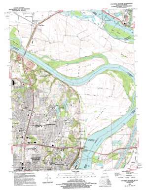
Columbia Bottom Topo Map Missouri
To zoom in, hover over the map of Columbia Bottom
USGS Topo Quad 38090g2 - 1:24,000 scale
| Topo Map Name: | Columbia Bottom |
| USGS Topo Quad ID: | 38090g2 |
| Print Size: | ca. 21 1/4" wide x 27" high |
| Southeast Coordinates: | 38.75° N latitude / 90.125° W longitude |
| Map Center Coordinates: | 38.8125° N latitude / 90.1875° W longitude |
| U.S. States: | MO, IL |
| Filename: | o38090g2.jpg |
| Download Map JPG Image: | Columbia Bottom topo map 1:24,000 scale |
| Map Type: | Topographic |
| Topo Series: | 7.5´ |
| Map Scale: | 1:24,000 |
| Source of Map Images: | United States Geological Survey (USGS) |
| Alternate Map Versions: |
Columbia Bottom MO 1935 Download PDF Buy paper map Columbia Bottom MO 1951, updated 1952 Download PDF Buy paper map Columbia Bottom MO 1951, updated 1959 Download PDF Buy paper map Columbia Bottom MO 1951, updated 1969 Download PDF Buy paper map Columbia Bottom MO 1951, updated 1974 Download PDF Buy paper map Columbia Bottom MO 1951, updated 1975 Download PDF Buy paper map Columbia Bottom MO 1951, updated 1983 Download PDF Buy paper map Columbia Bottom MO 1951, updated 1987 Download PDF Buy paper map Columbia Bottom MO 1994, updated 1995 Download PDF Buy paper map Columbia Bottom MO 1998, updated 1999 Download PDF Buy paper map Columbia Bottom MO 2012 Download PDF Buy paper map Columbia Bottom MO 2015 Download PDF Buy paper map |
1:24,000 Topo Quads surrounding Columbia Bottom
> Back to 38090e1 at 1:100,000 scale
> Back to 38090a1 at 1:250,000 scale
> Back to U.S. Topo Maps home
Columbia Bottom topo map: Gazetteer
Columbia Bottom: Airports
Lock and Dam Number 26 Heliport elevation 127m 416′Columbia Bottom: Bends
Columbia Bottom elevation 127m 416′Columbia Bottom: Bridges
Chain of Rocks Bridge elevation 122m 400′Chain of Rocks Bridge elevation 122m 400′
Lewis Bridge elevation 124m 406′
Columbia Bottom: Canals
Chain of Rocks Canal elevation 123m 403′Columbia Bottom: Capes
Mobile Island elevation 126m 413′Wilson Point elevation 128m 419′
Columbia Bottom: Crossings
Interchange 31A and 31B elevation 170m 557′Interchange 32 elevation 147m 482′
Interchange 33 elevation 152m 498′
Interchange 34 elevation 134m 439′
Columbia Bottom: Dams
Dam Number 27 elevation 122m 400′Lock and Dam 27 elevation 122m 400′
Lock and Dam Number Twenty-six elevation 127m 416′
Columbia Bottom: Falls
Chain of Rocks elevation 121m 396′Columbia Bottom: Guts
Alton Slough elevation 127m 416′Chouteau Slough elevation 124m 406′
Cora Island Chute elevation 126m 413′
Columbia Bottom: Islands
Chouteau Island elevation 124m 406′Cora Island elevation 128m 419′
Ellis Island elevation 127m 416′
Littles Island elevation 130m 426′
Maple Island elevation 127m 416′
Skinney Island elevation 130m 426′
Columbia Bottom: Lakes
Spanish Lake elevation 148m 485′Columbia Bottom: Parks
Chain of Rocks Park elevation 161m 528′Dundee Park elevation 147m 482′
Larimore Road Park elevation 162m 531′
Maple Island Conservation Area elevation 127m 416′
Columbia Bottom: Populated Places
Castle Point elevation 152m 498′Fort Bellefontaine elevation 153m 501′
Glasgow Village elevation 152m 498′
Kic-ka-poo Village (historical) elevation 129m 423′
Larimore elevation 156m 511′
Spanish Lake elevation 165m 541′
West Alton elevation 134m 439′
Columbia Bottom: Post Offices
North County Post Office elevation 158m 518′West Alton Post Office elevation 133m 436′
Columbia Bottom: Streams
Wood River elevation 123m 403′Columbia Bottom: Swamps
Wilson Island elevation 128m 419′Columbia Bottom digital topo map on disk
Buy this Columbia Bottom topo map showing relief, roads, GPS coordinates and other geographical features, as a high-resolution digital map file on DVD:


