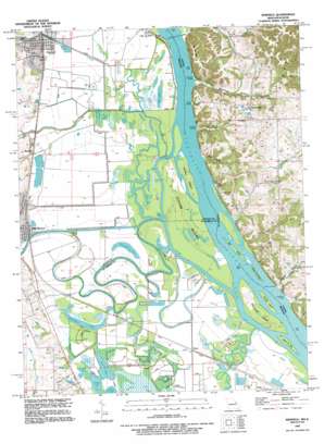
Winfield Topo Map Missouri
To zoom in, hover over the map of Winfield
USGS Topo Quad 38090h6 - 1:24,000 scale
| Topo Map Name: | Winfield |
| USGS Topo Quad ID: | 38090h6 |
| Print Size: | ca. 21 1/4" wide x 27" high |
| Southeast Coordinates: | 38.875° N latitude / 90.625° W longitude |
| Map Center Coordinates: | 38.9375° N latitude / 90.6875° W longitude |
| U.S. States: | MO, IL |
| Filename: | o38090h6.jpg |
| Download Map JPG Image: | Winfield topo map 1:24,000 scale |
| Map Type: | Topographic |
| Topo Series: | 7.5´ |
| Map Scale: | 1:24,000 |
| Source of Map Images: | United States Geological Survey (USGS) |
| Alternate Map Versions: |
Winfield MO 1954, updated 1959 Download PDF Buy paper map Winfield MO 1954, updated 1969 Download PDF Buy paper map Winfield MO 1954, updated 1983 Download PDF Buy paper map Winfield MO 1993, updated 1996 Download PDF Buy paper map Winfield MO 2012 Download PDF Buy paper map Winfield MO 2015 Download PDF Buy paper map |
1:24,000 Topo Quads surrounding Winfield
> Back to 38090e1 at 1:100,000 scale
> Back to 38090a1 at 1:250,000 scale
> Back to U.S. Topo Maps home
Winfield topo map: Gazetteer
Winfield: Basins
The Cave In elevation 134m 439′Winfield: Canals
Cuivre Canal elevation 128m 419′Winfield: Crossings
West Point Ferry elevation 128m 419′West Point Ferry elevation 128m 419′
Winfield: Dams
Westhoff Dam elevation 140m 459′Winfield: Guts
Fish Slough elevation 130m 426′Winfield: Islands
Cuivre Island elevation 131m 429′Hat Island elevation 130m 426′
Island Number 508 elevation 131m 429′
Johnson Island elevation 132m 433′
Martin Towhead elevation 131m 429′
Peruque Island elevation 129m 423′
Sweden Island elevation 132m 433′
Turkey Island elevation 131m 429′
Winfield: Lakes
Barrett Lake elevation 129m 423′Bernard Lake elevation 129m 423′
Brush Lake elevation 131m 429′
Camp Eter Lake elevation 131m 429′
Clear Lake elevation 129m 423′
Clear Lake elevation 131m 429′
Dark Lake elevation 128m 419′
Fish Lake elevation 128m 419′
Horseshoe Lake elevation 131m 429′
Horseshoe Lake elevation 130m 426′
Lharky Lake elevation 131m 429′
Maple Lake elevation 131m 429′
Mud Lake elevation 131m 429′
Turkey Lake elevation 129m 423′
Twin Lakes elevation 129m 423′
Winfield: Populated Places
Beechville elevation 165m 541′Brevator elevation 135m 442′
Cap au Gris elevation 133m 436′
Firma elevation 131m 429′
Old Monroe elevation 136m 446′
Winfield elevation 136m 446′
Winfield: Reservoirs
Westhoff Lake elevation 140m 459′Winfield: Ridges
Cap Au Gris elevation 203m 666′Winfield: Streams
Argent Slough elevation 128m 419′Bobs Creek elevation 131m 429′
Cuivre River elevation 129m 423′
Cuivre Slough elevation 128m 419′
McLean Creek elevation 133m 436′
Peruque Creek elevation 128m 419′
Winfield: Summits
Indian Hill elevation 187m 613′Winfield: Valleys
Bond Hollow elevation 130m 426′Cache Hollow elevation 131m 429′
Dogtown Hollow elevation 131m 429′
Winfield digital topo map on disk
Buy this Winfield topo map showing relief, roads, GPS coordinates and other geographical features, as a high-resolution digital map file on DVD:


