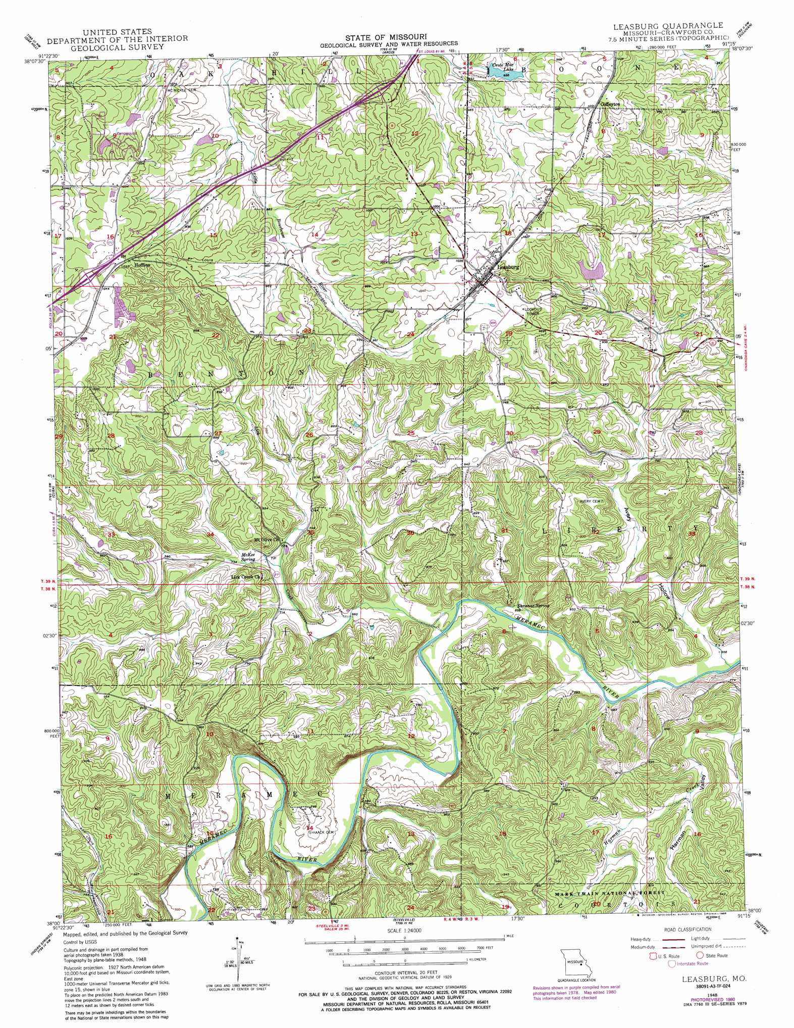
Leasburg Topo Map Missouri
To zoom in, hover over the map of Leasburg
USGS Topo Quad 38091a3 - 1:24,000 scale
| Topo Map Name: | Leasburg |
| USGS Topo Quad ID: | 38091a3 |
| Print Size: | ca. 21 1/4" wide x 27" high |
| Southeast Coordinates: | 38° N latitude / 91.25° W longitude |
| Map Center Coordinates: | 38.0625° N latitude / 91.3125° W longitude |
| U.S. State: | MO |
| Filename: | o38091a3.jpg |
| Download Map JPG Image: | Leasburg topo map 1:24,000 scale |
| Map Type: | Topographic |
| Topo Series: | 7.5´ |
| Map Scale: | 1:24,000 |
| Source of Map Images: | United States Geological Survey (USGS) |
| Alternate Map Versions: |
Leasburg MO 1948 Download PDF Buy paper map Leasburg MO 1948, updated 1962 Download PDF Buy paper map Leasburg MO 1948, updated 1968 Download PDF Buy paper map Leasburg MO 1948, updated 1980 Download PDF Buy paper map Leasburg MO 2012 Download PDF Buy paper map Leasburg MO 2015 Download PDF Buy paper map |
| FStopo: | US Forest Service topo Leasburg is available: Download FStopo PDF Download FStopo TIF |
1:24,000 Topo Quads surrounding Leasburg
Owensville West |
Owensville East |
Strain |
Spring Bluff |
Stanton |
Redbird |
Oak Hill |
Argo |
Sullivan |
Meramec State Park |
Rosati |
Cuba |
Leasburg |
Onondaga Cave |
Anthonies Mill |
Maramec Spring |
Indian Springs |
Steelville |
Huzzah |
Berryman |
Seaton |
Cook Station |
Cherryville |
Davisville |
Courtois |
> Back to 38091a1 at 1:100,000 scale
> Back to 38090a1 at 1:250,000 scale
> Back to U.S. Topo Maps home
Leasburg topo map: Gazetteer
Leasburg: Dams
Brummet Lake Dam elevation 254m 833′Budget Buster Dam elevation 249m 816′
Cuba Fish Farm Dam elevation 268m 879′
Ford Lake Dam elevation 268m 879′
Haladale Lake Dam elevation 269m 882′
Jellystone Park Dam elevation 292m 958′
Kemp Lake Dam elevation 285m 935′
Klontz Lake Dam elevation 289m 948′
Matthews Lake Dam elevation 268m 879′
Leasburg: Lakes
Blue Hole elevation 201m 659′Leasburg: Mines
Clapps Iron Mine elevation 257m 843′Griffith Iron Mine elevation 246m 807′
Railroad Iron Mine elevation 206m 675′
Zane Iron Mine elevation 230m 754′
Leasburg: Populated Places
Avery (historical) elevation 264m 866′Coffeyton elevation 304m 997′
Hofflins elevation 313m 1026′
Leasburg elevation 313m 1026′
Leasburg: Reservoirs
Boo-Boos Lake elevation 292m 958′Brummet Lake elevation 254m 833′
Crote Mac Lake elevation 285m 935′
Cuba Fish Farm Lake elevation 268m 879′
Ford Lake elevation 268m 879′
Kemp Lake elevation 285m 935′
Klontz Lake elevation 289m 948′
Matthews Lake elevation 268m 879′
Pine Lake elevation 269m 882′
Sprinkles Bass Hole elevation 249m 816′
Leasburg: Springs
McKee Spring elevation 220m 721′Saranac Spring elevation 203m 666′
Leasburg: Streams
Blairs Creek elevation 201m 659′Lick Creek elevation 201m 659′
Leasburg: Valleys
Avery Hollow elevation 201m 659′Harman Valley elevation 205m 672′
Leasburg digital topo map on disk
Buy this Leasburg topo map showing relief, roads, GPS coordinates and other geographical features, as a high-resolution digital map file on DVD: