Cuba Topo Map Missouri
To zoom in, hover over the map of Cuba
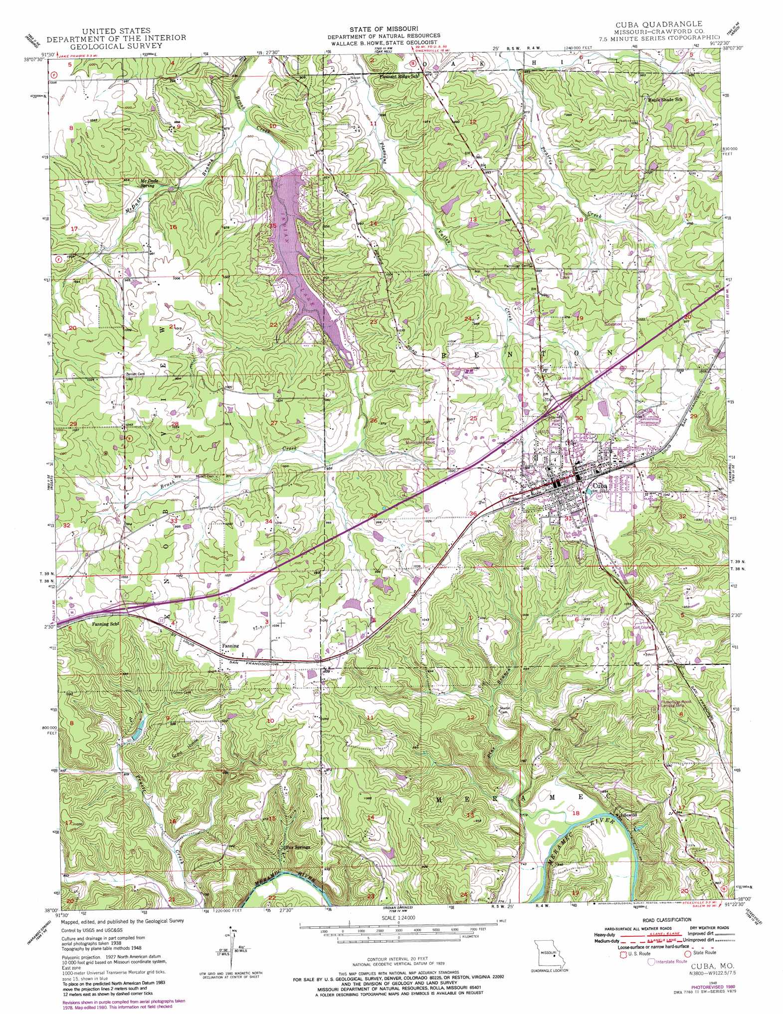
USGS Topo Quad 38091a4 - 1:24,000 scale
| Topo Map Name: | Cuba |
| USGS Topo Quad ID: | 38091a4 |
| Print Size: | ca. 21 1/4" wide x 27" high |
| Southeast Coordinates: | 38° N latitude / 91.375° W longitude |
| Map Center Coordinates: | 38.0625° N latitude / 91.4375° W longitude |
| U.S. State: | MO |
| Filename: | o38091a4.jpg |
| Download Map JPG Image: | Cuba topo map 1:24,000 scale |
| Map Type: | Topographic |
| Topo Series: | 7.5´ |
| Map Scale: | 1:24,000 |
| Source of Map Images: | United States Geological Survey (USGS) |
| Alternate Map Versions: |
Cuba MO 1948 Download PDF Buy paper map Cuba MO 1948, updated 1965 Download PDF Buy paper map Cuba MO 1948, updated 1967 Download PDF Buy paper map Cuba MO 1948, updated 1980 Download PDF Buy paper map Cuba MO 2012 Download PDF Buy paper map Cuba MO 2015 Download PDF Buy paper map |
1:24,000 Topo Quads surrounding Cuba
Belle |
Owensville West |
Owensville East |
Strain |
Spring Bluff |
High Gate |
Redbird |
Oak Hill |
Argo |
Sullivan |
Safe |
Rosati |
Cuba |
Leasburg |
Onondaga Cave |
Dillon |
Maramec Spring |
Indian Springs |
Steelville |
Huzzah |
Lecoma |
Seaton |
Cook Station |
Cherryville |
Davisville |
> Back to 38091a1 at 1:100,000 scale
> Back to 38090a1 at 1:250,000 scale
> Back to U.S. Topo Maps home
Cuba topo map: Gazetteer
Cuba: Airports
Cuba Municipal Airport elevation 311m 1020′Cuba: Dams
Castanis Lake Dam elevation 282m 925′Durbin Lake Dam elevation 302m 990′
Elders Lake Dam elevation 265m 869′
Gould Lake Dam elevation 297m 974′
Hartnett Lake Dam elevation 255m 836′
Hedrick Lake Dam elevation 256m 839′
Indian Hills Dam elevation 269m 882′
Kamler Lake Dam elevation 293m 961′
Keeney Lake Dam elevation 300m 984′
Lerwick Lake Dam elevation 293m 961′
Rutz Lake Dam elevation 318m 1043′
Sutter Lake Dam elevation 282m 925′
Weisel Lake Dam elevation 278m 912′
Cuba: Mines
Iron Ridge Number One Iron Bank elevation 330m 1082′Iron Ridge Number Two Iron Bank elevation 304m 997′
Isabella Iron Bank elevation 311m 1020′
J.P. Card and Companys Iron Bank elevation 285m 935′
Pinnel Iron Mine elevation 294m 964′
Senator Bucklands Iron Bank elevation 259m 849′
Varris Iron Mine elevation 299m 980′
Cuba: Populated Places
Amanda elevation 317m 1040′Cuba elevation 305m 1000′
Fanning elevation 321m 1053′
Fox Springs elevation 233m 764′
Idlewild elevation 224m 734′
Iron Center elevation 312m 1023′
Cuba: Reservoirs
Castanis Lake elevation 282m 925′Durbin Lake elevation 302m 990′
Elders Lake elevation 265m 869′
Gould Lake elevation 297m 974′
Hartnett Lake elevation 255m 836′
Hedrick Lake elevation 256m 839′
Indian Lake elevation 269m 882′
Kamler Lake elevation 293m 961′
Keeney Lake elevation 300m 984′
Lerwick Lake elevation 293m 961′
Rutz Lake elevation 318m 1043′
Sutter Lake elevation 282m 925′
Weisel Lake elevation 278m 912′
Cuba: Springs
McDade Spring elevation 279m 915′Cuba: Streams
McDade Branch elevation 257m 843′Pine Branch elevation 218m 715′
Cuba: Valleys
Grant Hollow elevation 245m 803′Cuba digital topo map on disk
Buy this Cuba topo map showing relief, roads, GPS coordinates and other geographical features, as a high-resolution digital map file on DVD: