Vienna Topo Map Missouri
To zoom in, hover over the map of Vienna
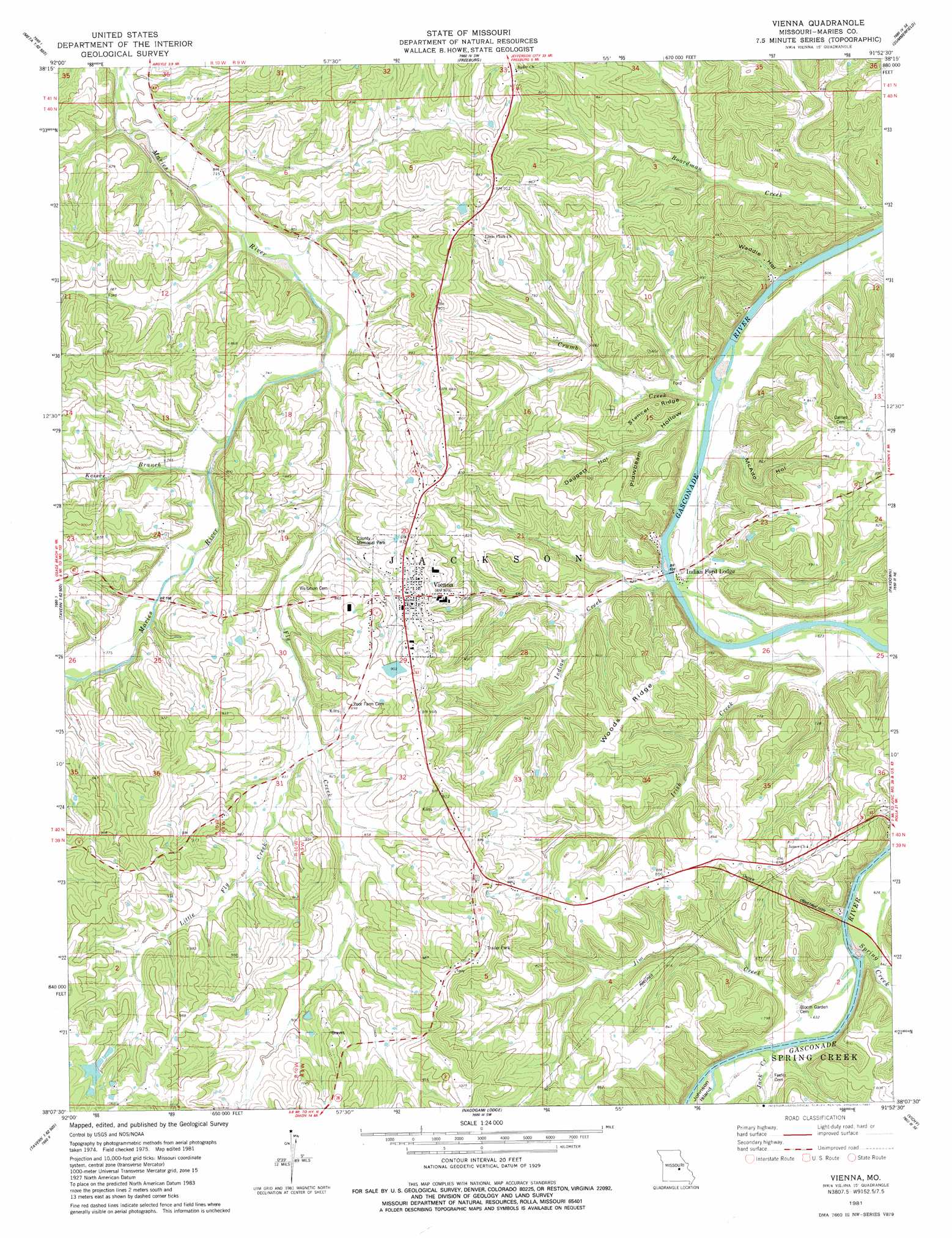
USGS Topo Quad 38091b8 - 1:24,000 scale
| Topo Map Name: | Vienna |
| USGS Topo Quad ID: | 38091b8 |
| Print Size: | ca. 21 1/4" wide x 27" high |
| Southeast Coordinates: | 38.125° N latitude / 91.875° W longitude |
| Map Center Coordinates: | 38.1875° N latitude / 91.9375° W longitude |
| U.S. State: | MO |
| Filename: | o38091b8.jpg |
| Download Map JPG Image: | Vienna topo map 1:24,000 scale |
| Map Type: | Topographic |
| Topo Series: | 7.5´ |
| Map Scale: | 1:24,000 |
| Source of Map Images: | United States Geological Survey (USGS) |
| Alternate Map Versions: |
Vienna MO 1981, updated 1981 Download PDF Buy paper map Vienna MO 2012 Download PDF Buy paper map Vienna MO 2015 Download PDF Buy paper map |
1:24,000 Topo Quads surrounding Vienna
Wardsville |
Westphalia West |
Westphalia East |
Linn |
Cooper Hill |
Meta |
Argyle |
Freeburg |
Summerfield |
Belle |
Van Cleve |
Brinktown |
Vienna |
Paydown |
High Gate |
Brays |
Big Bend |
Nagogami Lodge |
Vichy |
Safe |
Hancock |
Dixon |
Newburg |
Rolla |
Dillon |
> Back to 38091a1 at 1:100,000 scale
> Back to 38090a1 at 1:250,000 scale
> Back to U.S. Topo Maps home
Vienna topo map: Gazetteer
Vienna: Bridges
Vienna Bridge elevation 186m 610′Vienna: Dams
Bowman Lake Dam elevation 275m 902′Murphey Lake Dam elevation 305m 1000′
Swarthout Lake Dam elevation 263m 862′
Vienna: Islands
Johnson Island elevation 191m 626′Vienna: Parks
Maries County Memorial Park elevation 253m 830′Vienna: Populated Places
James Brothers elevation 201m 659′Johnson Ford (historical) elevation 188m 616′
Vienna elevation 267m 875′
Vienna: Reservoirs
Mononame 67 Lake elevation 275m 902′Murphy Lake elevation 305m 1000′
Vienna: Ridges
Stencer Ridge elevation 239m 784′Woods Ridge elevation 262m 859′
Vienna: Slopes
Tie Slide elevation 186m 610′Tie Slide elevation 191m 626′
Vienna: Springs
Lanes Spring elevation 184m 603′Vienna: Streams
Crumb Creek elevation 184m 603′Fly Creek elevation 219m 718′
Indian Creek elevation 191m 626′
Irish Branch elevation 188m 616′
Jack Creek elevation 189m 620′
Jim Creek elevation 215m 705′
Keiser Branch elevation 226m 741′
Little Fly Creek elevation 245m 803′
Spring Creek elevation 189m 620′
Vienna: Summits
House Mounds elevation 250m 820′House Mounds elevation 230m 754′
Vienna: Valleys
Daggett Hollow elevation 197m 646′Plowbeam Hollow elevation 186m 610′
Waddle Hollow elevation 185m 606′
Vienna digital topo map on disk
Buy this Vienna topo map showing relief, roads, GPS coordinates and other geographical features, as a high-resolution digital map file on DVD: