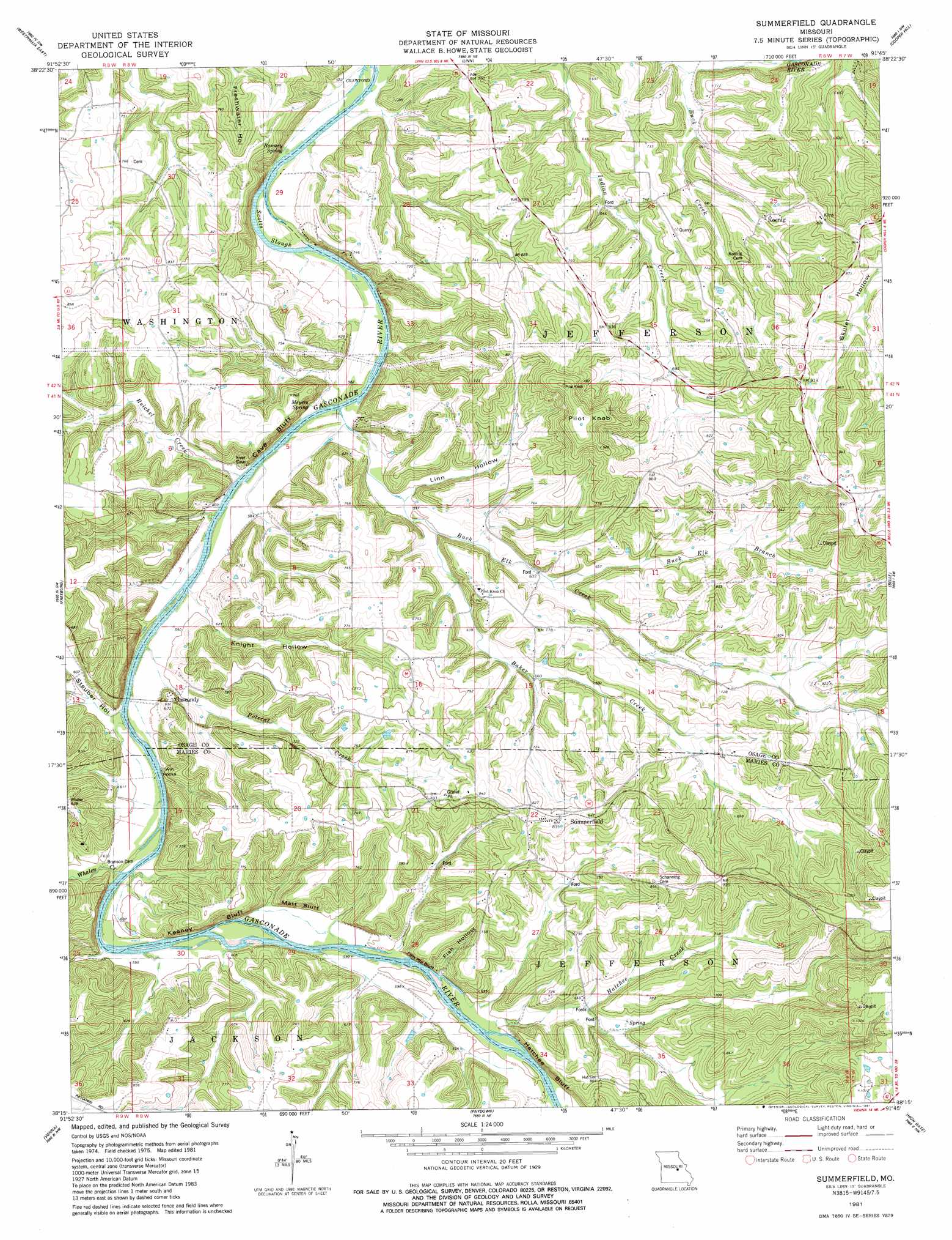
Summerfield Topo Map Missouri
To zoom in, hover over the map of Summerfield
USGS Topo Quad 38091c7 - 1:24,000 scale
| Topo Map Name: | Summerfield |
| USGS Topo Quad ID: | 38091c7 |
| Print Size: | ca. 21 1/4" wide x 27" high |
| Southeast Coordinates: | 38.25° N latitude / 91.75° W longitude |
| Map Center Coordinates: | 38.3125° N latitude / 91.8125° W longitude |
| U.S. State: | MO |
| Filename: | o38091c7.jpg |
| Download Map JPG Image: | Summerfield topo map 1:24,000 scale |
| Map Type: | Topographic |
| Topo Series: | 7.5´ |
| Map Scale: | 1:24,000 |
| Source of Map Images: | United States Geological Survey (USGS) |
| Alternate Map Versions: |
Summerfield MO 1981, updated 1981 Download PDF Buy paper map Summerfield MO 2012 Download PDF Buy paper map Summerfield MO 2015 Download PDF Buy paper map |
1:24,000 Topo Quads surrounding Summerfield
Osage City |
Loose Creek |
Luystown |
Fredericksburg |
Pershing |
Westphalia West |
Westphalia East |
Linn |
Cooper Hill |
Coerlisch Ridge |
Argyle |
Freeburg |
Summerfield |
Belle |
Owensville West |
Brinktown |
Vienna |
Paydown |
High Gate |
Redbird |
Big Bend |
Nagogami Lodge |
Vichy |
Safe |
Rosati |
> Back to 38091a1 at 1:100,000 scale
> Back to 38090a1 at 1:250,000 scale
> Back to U.S. Topo Maps home
Summerfield topo map: Gazetteer
Summerfield: Airports
Stickle Cattle Farms Airport elevation 227m 744′Summerfield: Cliffs
Cave Bluff elevation 173m 567′Fish Hollow Bluff elevation 201m 659′
Hatchee Bluff elevation 212m 695′
Huckleberry Bluff elevation 300m 984′
Keeney Bluff elevation 209m 685′
Matt Bluff elevation 221m 725′
Sand Bluff elevation 276m 905′
Twin Rocks elevation 176m 577′
Summerfield: Populated Places
Daggetts Ford (historical) elevation 177m 580′Gascondy elevation 203m 666′
Koenig elevation 208m 682′
Summerfield elevation 260m 853′
Summerfield: Springs
Meyers Spring elevation 175m 574′Ramsey Spring elevation 175m 574′
Summerfield: Streams
Baker Creek elevation 182m 597′Buck Elk Branch elevation 194m 636′
Buck Elk Creek elevation 176m 577′
Hatchee Creek elevation 182m 597′
Polecat Creek elevation 176m 577′
Reichel Creek elevation 174m 570′
Scotts Slough elevation 172m 564′
Whalen Creek elevation 187m 613′
Summerfield: Summits
Pilot Knob elevation 300m 984′Summerfield: Valleys
Boehmer Hollow elevation 178m 583′Fish Hollow elevation 177m 580′
Knight Hollow elevation 174m 570′
Linn Hollow elevation 190m 623′
Steuber Hollow elevation 179m 587′
Summerfield digital topo map on disk
Buy this Summerfield topo map showing relief, roads, GPS coordinates and other geographical features, as a high-resolution digital map file on DVD: