Swiss Topo Map Missouri
To zoom in, hover over the map of Swiss
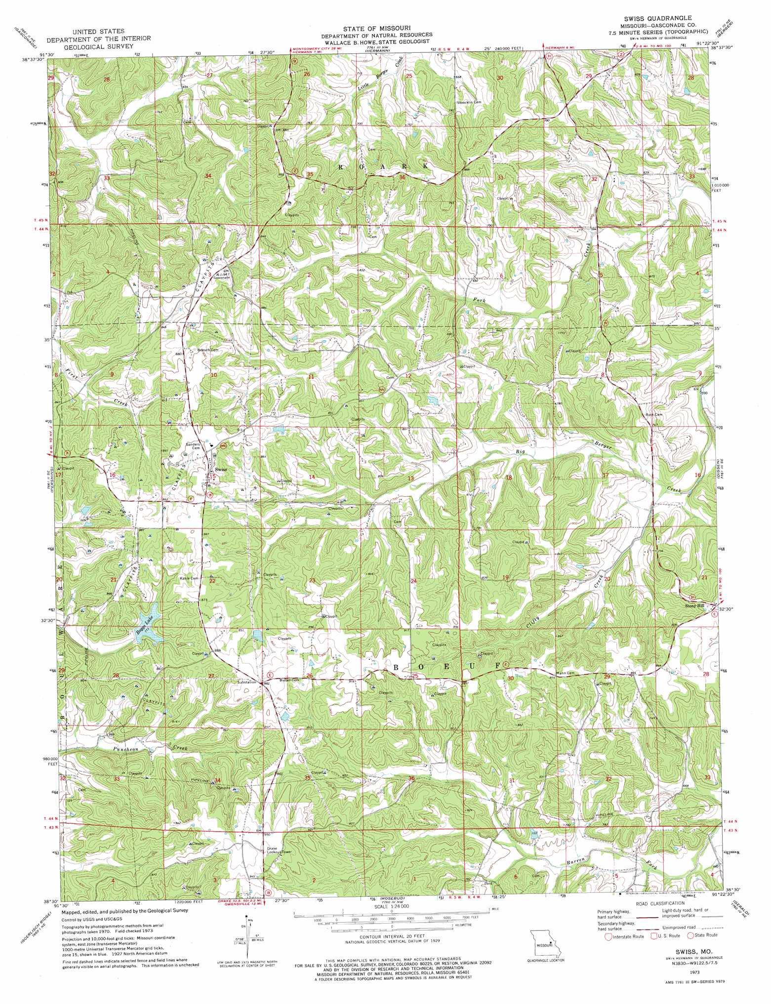
USGS Topo Quad 38091e4 - 1:24,000 scale
| Topo Map Name: | Swiss |
| USGS Topo Quad ID: | 38091e4 |
| Print Size: | ca. 21 1/4" wide x 27" high |
| Southeast Coordinates: | 38.5° N latitude / 91.375° W longitude |
| Map Center Coordinates: | 38.5625° N latitude / 91.4375° W longitude |
| U.S. State: | MO |
| Filename: | o38091e4.jpg |
| Download Map JPG Image: | Swiss topo map 1:24,000 scale |
| Map Type: | Topographic |
| Topo Series: | 7.5´ |
| Map Scale: | 1:24,000 |
| Source of Map Images: | United States Geological Survey (USGS) |
| Alternate Map Versions: |
Swiss MO 1973, updated 1975 Download PDF Buy paper map Swiss MO 2012 Download PDF Buy paper map Swiss MO 2015 Download PDF Buy paper map |
1:24,000 Topo Quads surrounding Swiss
Readsville |
Americus |
Pinnacle Lake |
Jonesburg |
Warrenton |
Morrison |
Gasconade |
Hermann |
Berger |
Treloar |
Fredericksburg |
Pershing |
Swiss |
Dissen |
New Haven |
Cooper Hill |
Coerlisch Ridge |
Rosebud |
Gerald |
Leslie |
Belle |
Owensville West |
Owensville East |
Strain |
Spring Bluff |
> Back to 38091e1 at 1:100,000 scale
> Back to 38090a1 at 1:250,000 scale
> Back to U.S. Topo Maps home
Swiss topo map: Gazetteer
Swiss: Dams
Busch Lake Dam elevation 202m 662′Fricke Lake Dam elevation 233m 764′
Garofalo Lake Dam elevation 219m 718′
Godefroid Lake Dam elevation 243m 797′
Laboube Lake Dam elevation 264m 866′
Lake Carawood Dam elevation 256m 839′
Lee Gade Dam elevation 180m 590′
Sammons Lake Dam elevation 224m 734′
Schneider Lake Lower Dam elevation 217m 711′
Schneider Lake Upper Dam elevation 226m 741′
Swiss Lake Estates Dam elevation 235m 770′
Weiss Lake Dam elevation 263m 862′
Swiss: Populated Places
Little Berger elevation 235m 770′Swiss elevation 276m 905′
Swiss: Post Offices
Little Berger Post Office (historical) elevation 235m 770′Swiss: Reservoirs
Boggs Lake elevation 235m 770′Carawood Lake elevation 256m 839′
Eugene Moeckli Lake elevation 264m 866′
Harry Sammons Lake elevation 224m 734′
Lake Weiss elevation 263m 862′
Lazy S Lake elevation 180m 590′
Swiss: Streams
Calico Branch elevation 171m 561′Clifty Creek elevation 185m 606′
Swiss digital topo map on disk
Buy this Swiss topo map showing relief, roads, GPS coordinates and other geographical features, as a high-resolution digital map file on DVD: