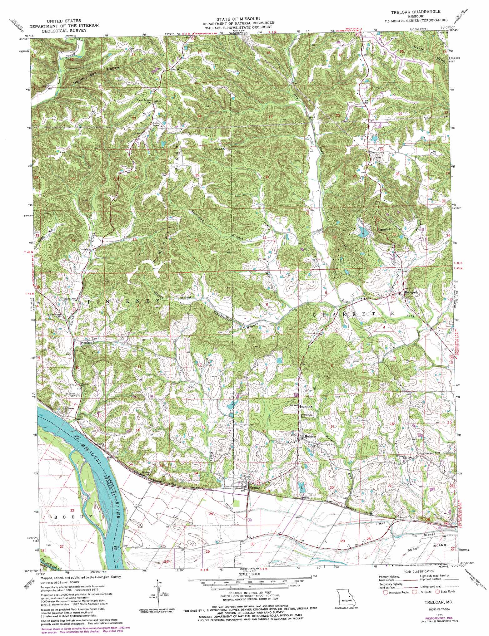
Treloar Topo Map Missouri
To zoom in, hover over the map of Treloar
USGS Topo Quad 38091f2 - 1:24,000 scale
| Topo Map Name: | Treloar |
| USGS Topo Quad ID: | 38091f2 |
| Print Size: | ca. 21 1/4" wide x 27" high |
| Southeast Coordinates: | 38.625° N latitude / 91.125° W longitude |
| Map Center Coordinates: | 38.6875° N latitude / 91.1875° W longitude |
| U.S. State: | MO |
| Filename: | o38091f2.jpg |
| Download Map JPG Image: | Treloar topo map 1:24,000 scale |
| Map Type: | Topographic |
| Topo Series: | 7.5´ |
| Map Scale: | 1:24,000 |
| Source of Map Images: | United States Geological Survey (USGS) |
| Alternate Map Versions: |
Treloar MO 1973, updated 1975 Download PDF Buy paper map Treloar MO 1973, updated 1986 Download PDF Buy paper map Treloar MO 2012 Download PDF Buy paper map Treloar MO 2015 Download PDF Buy paper map |
1:24,000 Topo Quads surrounding Treloar
New Florence |
Bellflower South |
Hawk Point |
Warrenton Ne |
Troy |
Pinnacle Lake |
Jonesburg |
Warrenton |
Wright City |
Foristell |
Hermann |
Berger |
Treloar |
Marthasville |
New Melle |
Swiss |
Dissen |
New Haven |
Washington West |
Washington East |
Rosebud |
Gerald |
Leslie |
Union |
Moselle |
> Back to 38091e1 at 1:100,000 scale
> Back to 38090a1 at 1:250,000 scale
> Back to U.S. Topo Maps home
Treloar topo map: Gazetteer
Treloar: Dams
Aspenhoff Lake Dam elevation 179m 587′Krueger Lake Dam elevation 177m 580′
Lucks Lake Dam elevation 168m 551′
Ruegge Lake Dam elevation 157m 515′
Wagner Lake Dam elevation 238m 780′
Treloar: Populated Places
Aspenhoff elevation 192m 629′Concord Hill elevation 185m 606′
Holstein elevation 196m 643′
Hopewell elevation 165m 541′
Kruegerville (historical) elevation 152m 498′
Pinckney elevation 160m 524′
Treloar elevation 153m 501′
Treloar: Post Offices
Gofeld Post Office (historical) elevation 269m 882′Treloar: Reservoirs
Duncan Lake elevation 157m 515′Krueger Lake elevation 177m 580′
Treloar: Ridges
Pinckney Ridge elevation 276m 905′Treloar: Streams
Hopewell Creek elevation 154m 505′Howard Branch elevation 192m 629′
Kochs Creek elevation 148m 485′
Little Dry Fork elevation 158m 518′
Pepplemeyer Branch elevation 167m 547′
Smith Creek elevation 149m 488′
Stuecken Branch elevation 154m 505′
Stuerman Branch elevation 189m 620′
Water Run elevation 150m 492′
Treloar: Valleys
Devils Den Hollow elevation 175m 574′Polston Hollow elevation 197m 646′
Treloar digital topo map on disk
Buy this Treloar topo map showing relief, roads, GPS coordinates and other geographical features, as a high-resolution digital map file on DVD: