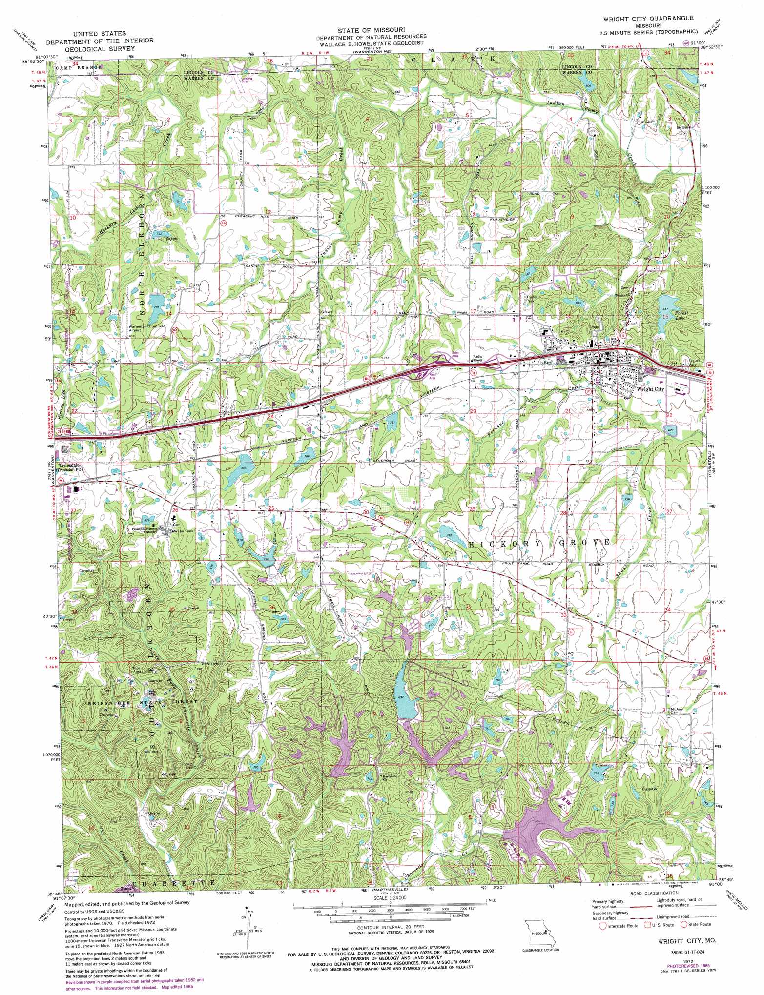
Wright City Topo Map Missouri
To zoom in, hover over the map of Wright City
USGS Topo Quad 38091g1 - 1:24,000 scale
| Topo Map Name: | Wright City |
| USGS Topo Quad ID: | 38091g1 |
| Print Size: | ca. 21 1/4" wide x 27" high |
| Southeast Coordinates: | 38.75° N latitude / 91° W longitude |
| Map Center Coordinates: | 38.8125° N latitude / 91.0625° W longitude |
| U.S. State: | MO |
| Filename: | o38091g1.jpg |
| Download Map JPG Image: | Wright City topo map 1:24,000 scale |
| Map Type: | Topographic |
| Topo Series: | 7.5´ |
| Map Scale: | 1:24,000 |
| Source of Map Images: | United States Geological Survey (USGS) |
| Alternate Map Versions: |
Wright City MO 1972, updated 1974 Download PDF Buy paper map Wright City MO 1972, updated 1986 Download PDF Buy paper map Wright City MO 2012 Download PDF Buy paper map Wright City MO 2015 Download PDF Buy paper map |
1:24,000 Topo Quads surrounding Wright City
Bellflower North |
Truxton |
Silex |
Okete |
Luckett Ridge |
Bellflower South |
Hawk Point |
Warrenton Ne |
Troy |
Maryknoll |
Jonesburg |
Warrenton |
Wright City |
Foristell |
Wentzville |
Berger |
Treloar |
Marthasville |
New Melle |
Defiance |
Dissen |
New Haven |
Washington West |
Washington East |
Labadie |
> Back to 38091e1 at 1:100,000 scale
> Back to 38090a1 at 1:250,000 scale
> Back to U.S. Topo Maps home
Wright City topo map: Gazetteer
Wright City: Airports
C E F Airport elevation 260m 853′Wright City: Dams
Boone Trail Farm Lake Dam elevation 242m 793′Boulanger Lake Dam elevation 232m 761′
Broussard Lake Dam elevation 224m 734′
Cedar Knoll Farm Lake Dam elevation 244m 800′
Dunn Lake Dam elevation 223m 731′
Forest Lake Dam elevation 192m 629′
Froelich Lake Dam elevation 219m 718′
Gettinger Lake Dam elevation 225m 738′
Hunt Lake Dam elevation 240m 787′
Innsbrook Estates Dam Number 1 elevation 208m 682′
Johnson Lake Dam elevation 209m 685′
Lake Innsbrook Dam elevation 201m 659′
Lake Lucern Dam elevation 210m 688′
Lake Scheffborg Dam elevation 227m 744′
Mononame 318 Dam elevation 257m 843′
Mudd Lake Dam elevation 177m 580′
N and W Railroad Section 19 Dam elevation 225m 738′
Nine Acre Lake Plat 6 Dam elevation 202m 662′
Olive Ballas Realty Company Section 24 Dam elevation 238m 780′
Palazzo Lake Dam elevation 202m 662′
Passionist Fathers Dam elevation 255m 836′
Prior Lake Dam elevation 231m 757′
Rogers Lake Dam elevation 230m 754′
Sherman Lake Dam elevation 229m 751′
Shields Lake Dam elevation 234m 767′
Siegmund Lake Dam elevation 226m 741′
Stark Lake Dam elevation 242m 793′
Thiele Lake Dam elevation 190m 623′
Vitt Lake Dam elevation 244m 800′
Wanderfern Lake Dam elevation 193m 633′
Windy Knoll Lake Dam elevation 228m 748′
Wright City: Forests
Reifsnider State Forest elevation 265m 869′Wright City: Populated Places
Innsbrook elevation 203m 666′Wright City elevation 223m 731′
Wright City: Reservoirs
Boone Trail Farm Lake elevation 242m 793′Cedar Knoll Farm Lake elevation 244m 800′
End Brook Lake elevation 202m 662′
Forest Lake elevation 192m 629′
Joe Phegleg Lake elevation 234m 767′
Lake Lucern elevation 210m 688′
Lake Scheffborg elevation 227m 744′
Leprechaun Lake elevation 219m 718′
Passionist Fathers Lake elevation 255m 836′
Prior Lake elevation 231m 757′
Windy Knoll Lake elevation 228m 748′
Wright City: Streams
Crow Branch elevation 189m 620′Skunk Creek elevation 203m 666′
Wright City: Valleys
Skunk Hollow elevation 204m 669′Wright City digital topo map on disk
Buy this Wright City topo map showing relief, roads, GPS coordinates and other geographical features, as a high-resolution digital map file on DVD: