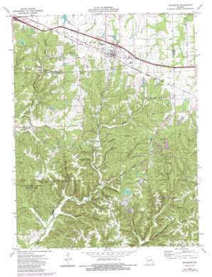
Jonesburg Topo Map Missouri
To zoom in, hover over the map of Jonesburg
USGS Topo Quad 38091g3 - 1:24,000 scale
| Topo Map Name: | Jonesburg |
| USGS Topo Quad ID: | 38091g3 |
| Print Size: | ca. 21 1/4" wide x 27" high |
| Southeast Coordinates: | 38.75° N latitude / 91.25° W longitude |
| Map Center Coordinates: | 38.8125° N latitude / 91.3125° W longitude |
| U.S. State: | MO |
| Filename: | o38091g3.jpg |
| Download Map JPG Image: | Jonesburg topo map 1:24,000 scale |
| Map Type: | Topographic |
| Topo Series: | 7.5´ |
| Map Scale: | 1:24,000 |
| Source of Map Images: | United States Geological Survey (USGS) |
| Alternate Map Versions: |
Jonesburg MO 1973, updated 1975 Download PDF Buy paper map Jonesburg MO 1973, updated 1986 Download PDF Buy paper map Jonesburg MO 2012 Download PDF Buy paper map Jonesburg MO 2015 Download PDF Buy paper map |
1:24,000 Topo Quads surrounding Jonesburg
> Back to 38091e1 at 1:100,000 scale
> Back to 38090a1 at 1:250,000 scale
> Back to U.S. Topo Maps home
Jonesburg topo map: Gazetteer
Jonesburg: Airports
Adventures Aloft Airport elevation 263m 862′Tightsqueeze Field elevation 252m 826′
Jonesburg: Dams
Bullar Lake Dam elevation 207m 679′Casper Lake Dam elevation 256m 839′
Crancers Lake Dam elevation 234m 767′
Crancers Lake Section 7 South Dam elevation 238m 780′
Hambauch Lake Dam elevation 262m 859′
Hicks Lake Section 20 North Dam elevation 270m 885′
Hicks Lake Section 20 South Dam elevation 271m 889′
Kelly Lake Dam elevation 231m 757′
Longstreet Lake Dam elevation 208m 682′
Scofield Lake Number 3 Dam elevation 261m 856′
Jonesburg: Forests
Little Lost Creek State Forest elevation 248m 813′Jonesburg: Populated Places
Jonesburg elevation 275m 902′Jonesburg: Reservoirs
Crancers Lake elevation 234m 767′John Scofield Lake elevation 261m 856′
Robertson Lake elevation 231m 757′
Twin Echoes Lake elevation 208m 682′
Jonesburg: Ridges
Donahue Ridge elevation 255m 836′Kirby Ridge elevation 269m 882′
Pea Ridge elevation 274m 898′
Jonesburg: Streams
Camp Sandy Creek elevation 165m 541′Muddy Creek elevation 183m 600′
Watkins Branch elevation 181m 593′
Jonesburg: Valleys
Abe Hollow elevation 177m 580′Baker Hollow elevation 193m 633′
Camp Sandy Hollow elevation 171m 561′
Coleman Hollow elevation 177m 580′
Dead Hollow elevation 185m 606′
Giesel Hollow elevation 181m 593′
Greyham Hollow elevation 183m 600′
Hall Hollow elevation 200m 656′
Henley Hollow elevation 189m 620′
Hog Pen Hollow elevation 182m 597′
Jack Hollow elevation 222m 728′
Jordan Hollow elevation 168m 551′
Kelly Hollow elevation 190m 623′
Lepp Hollow elevation 191m 626′
Little Camp Sandy Hollow elevation 171m 561′
Low Gap Hollow elevation 165m 541′
Razor Hollow elevation 162m 531′
Wilson Hollow elevation 165m 541′
Wolf Den Hollow elevation 193m 633′
Jonesburg digital topo map on disk
Buy this Jonesburg topo map showing relief, roads, GPS coordinates and other geographical features, as a high-resolution digital map file on DVD:


