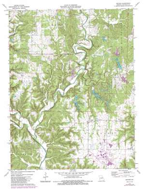
Reform Topo Map Missouri
To zoom in, hover over the map of Reform
USGS Topo Quad 38091g7 - 1:24,000 scale
| Topo Map Name: | Reform |
| USGS Topo Quad ID: | 38091g7 |
| Print Size: | ca. 21 1/4" wide x 27" high |
| Southeast Coordinates: | 38.75° N latitude / 91.75° W longitude |
| Map Center Coordinates: | 38.8125° N latitude / 91.8125° W longitude |
| U.S. State: | MO |
| Filename: | o38091g7.jpg |
| Download Map JPG Image: | Reform topo map 1:24,000 scale |
| Map Type: | Topographic |
| Topo Series: | 7.5´ |
| Map Scale: | 1:24,000 |
| Source of Map Images: | United States Geological Survey (USGS) |
| Alternate Map Versions: |
Reform MO 1975, updated 1977 Download PDF Buy paper map Reform MO 1975, updated 1986 Download PDF Buy paper map Reform MO 2012 Download PDF Buy paper map Reform MO 2015 Download PDF Buy paper map |
1:24,000 Topo Quads surrounding Reform
> Back to 38091e1 at 1:100,000 scale
> Back to 38090a1 at 1:250,000 scale
> Back to U.S. Topo Maps home
Reform topo map: Gazetteer
Reform: Dams
Canyon Lake Lower Dam elevation 195m 639′Canyon Lake Upper Dam elevation 216m 708′
Herring Lake Dam elevation 227m 744′
Konrad Dam elevation 234m 767′
Lake Lochaweeno Dam elevation 212m 695′
Lake Thunderbird Upper Dam elevation 206m 675′
Lawrence Dam elevation 224m 734′
Lee Sualts Dam elevation 227m 744′
Lost Canyon Lakes Section 25 Upper Dam elevation 225m 738′
Lost Canyon Lakes Section 26 East Dam elevation 225m 738′
Lost Canyon Lakes Section 26 West Dam elevation 225m 738′
Muckler and Sielfleisch Lake Dam elevation 212m 695′
Sielfleisch Lake Section 25 Dam elevation 213m 698′
Thunderbird Lake Dam elevation 198m 649′
Winfield Investment Lake Dam elevation 225m 738′
Reform: Populated Places
Reform elevation 256m 839′Toledo elevation 223m 731′
Yucatan elevation 245m 803′
Reform: Reservoirs
Canyon Lake elevation 216m 708′Canyon Lake elevation 195m 639′
Lake Lochaweeno elevation 212m 695′
Muckler and Sieleisch Lake elevation 212m 695′
Thunderbird Lake elevation 198m 649′
Reform: Streams
Booth Branch elevation 159m 521′Cow Creek elevation 166m 544′
Craghead Branch elevation 161m 528′
Crows Fork Creek elevation 159m 521′
Dyers Branch elevation 185m 606′
Halls Creek elevation 159m 521′
May Branch elevation 159m 521′
Pinch Creek elevation 175m 574′
Stinson Creek elevation 159m 521′
Reform: Valleys
Lawrence Hollow elevation 169m 554′Reform digital topo map on disk
Buy this Reform topo map showing relief, roads, GPS coordinates and other geographical features, as a high-resolution digital map file on DVD:


