Montgomery City Topo Map Missouri
To zoom in, hover over the map of Montgomery City
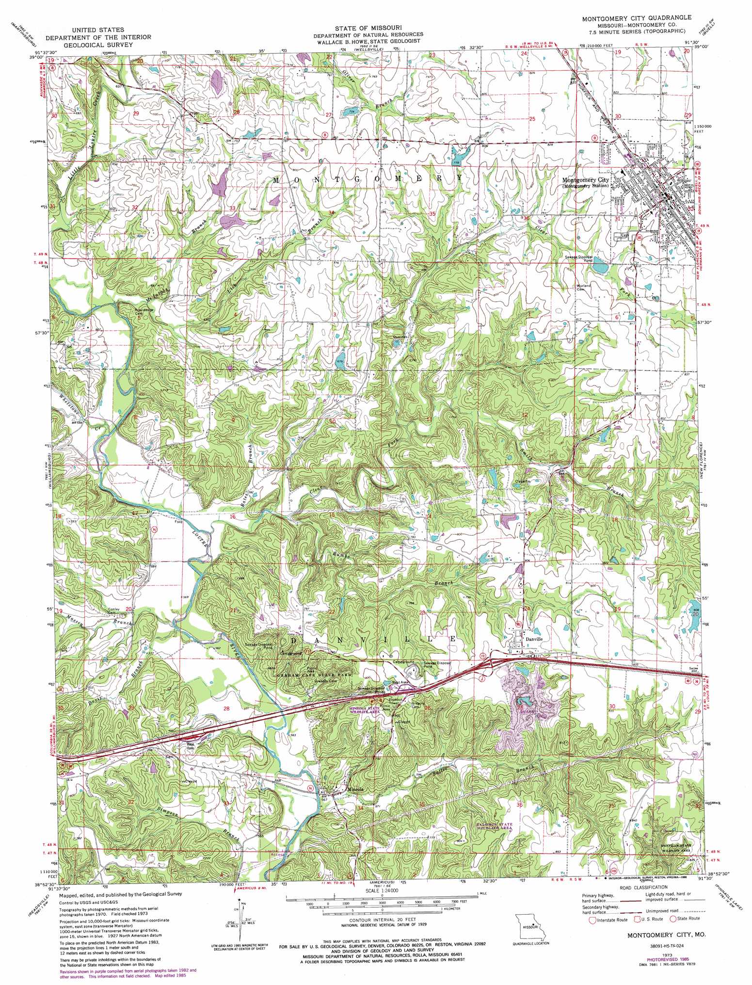
USGS Topo Quad 38091h5 - 1:24,000 scale
| Topo Map Name: | Montgomery City |
| USGS Topo Quad ID: | 38091h5 |
| Print Size: | ca. 21 1/4" wide x 27" high |
| Southeast Coordinates: | 38.875° N latitude / 91.5° W longitude |
| Map Center Coordinates: | 38.9375° N latitude / 91.5625° W longitude |
| U.S. State: | MO |
| Filename: | o38091h5.jpg |
| Download Map JPG Image: | Montgomery City topo map 1:24,000 scale |
| Map Type: | Topographic |
| Topo Series: | 7.5´ |
| Map Scale: | 1:24,000 |
| Source of Map Images: | United States Geological Survey (USGS) |
| Alternate Map Versions: |
Montgomery City MO 1973, updated 1975 Download PDF Buy paper map Montgomery City MO 1973, updated 1986 Download PDF Buy paper map Montgomery City MO 2012 Download PDF Buy paper map Montgomery City MO 2015 Download PDF Buy paper map |
1:24,000 Topo Quads surrounding Montgomery City
Mexico East |
Laddonia |
Vandalia Lake |
Middletown |
New Hartford |
Mexico Se |
Martinsburg |
Wellsville |
Buell |
Bellflower North |
Calwood |
Williamsburg |
Montgomery City |
New Florence |
Bellflower South |
Reform |
Readsville |
Americus |
Pinnacle Lake |
Jonesburg |
Mokane East |
Morrison |
Gasconade |
Hermann |
Berger |
> Back to 38091e1 at 1:100,000 scale
> Back to 38090a1 at 1:250,000 scale
> Back to U.S. Topo Maps home
Montgomery City topo map: Gazetteer
Montgomery City: Dams
Easterday Dam elevation 247m 810′Feldkamp Lake Dam elevation 206m 675′
Hoffman Lake Dam elevation 203m 666′
Irvin Beabout Dam elevation 223m 731′
McClain Lake Dam elevation 232m 761′
Pointdexter Lake Dam elevation 218m 715′
Polizzi Lake Dam elevation 206m 675′
Stevens Lake North Dam elevation 206m 675′
Stevens Lake South Dam elevation 207m 679′
Sturgeon Lake Dam elevation 233m 764′
Werges Lake Dam elevation 234m 767′
Montgomery City: Parks
Baldwin State Wildlife Area elevation 237m 777′Graham Cave State Park elevation 220m 721′
Mineola State Wildlife Area elevation 250m 820′
Montgomery City: Populated Places
Danville elevation 248m 813′Mineola elevation 171m 561′
Montgomery City elevation 251m 823′
Montgomery City: Reservoirs
Bob Hoffman Lake elevation 203m 666′Hickory Meadows Lake elevation 206m 675′
Irvin Beabout Lake elevation 223m 731′
Nobles Lake elevation 233m 764′
Pierson Lake elevation 247m 810′
Shore Crest Lake elevation 234m 767′
Montgomery City: Streams
Bates Branch elevation 171m 561′Clear Fork elevation 170m 557′
Davis Branch elevation 169m 554′
Lick Branch elevation 180m 590′
Little Loutre Creek elevation 177m 580′
Massey Branch elevation 169m 554′
McIntosh Branch elevation 176m 577′
Rumbo Branch elevation 175m 574′
Sallee Branch elevation 164m 538′
Smith Branch elevation 187m 613′
Whetstone Creek elevation 175m 574′
Montgomery City digital topo map on disk
Buy this Montgomery City topo map showing relief, roads, GPS coordinates and other geographical features, as a high-resolution digital map file on DVD: