Williamsburg Topo Map Missouri
To zoom in, hover over the map of Williamsburg
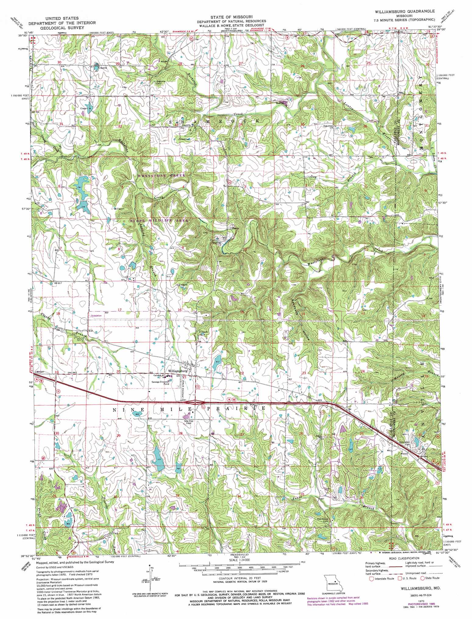
USGS Topo Quad 38091h6 - 1:24,000 scale
| Topo Map Name: | Williamsburg |
| USGS Topo Quad ID: | 38091h6 |
| Print Size: | ca. 21 1/4" wide x 27" high |
| Southeast Coordinates: | 38.875° N latitude / 91.625° W longitude |
| Map Center Coordinates: | 38.9375° N latitude / 91.6875° W longitude |
| U.S. State: | MO |
| Filename: | o38091h6.jpg |
| Download Map JPG Image: | Williamsburg topo map 1:24,000 scale |
| Map Type: | Topographic |
| Topo Series: | 7.5´ |
| Map Scale: | 1:24,000 |
| Source of Map Images: | United States Geological Survey (USGS) |
| Alternate Map Versions: |
Williamsburg MO 1973, updated 1975 Download PDF Buy paper map Williamsburg MO 1973, updated 1986 Download PDF Buy paper map Williamsburg MO 2012 Download PDF Buy paper map Williamsburg MO 2015 Download PDF Buy paper map |
1:24,000 Topo Quads surrounding Williamsburg
Mexico West |
Mexico East |
Laddonia |
Vandalia Lake |
Middletown |
Auxvasse |
Mexico Se |
Martinsburg |
Wellsville |
Buell |
Kingdom City |
Calwood |
Williamsburg |
Montgomery City |
New Florence |
Fulton |
Reform |
Readsville |
Americus |
Pinnacle Lake |
Mokane West |
Mokane East |
Morrison |
Gasconade |
Hermann |
> Back to 38091e1 at 1:100,000 scale
> Back to 38090a1 at 1:250,000 scale
> Back to U.S. Topo Maps home
Williamsburg topo map: Gazetteer
Williamsburg: Airports
Eckerts Airstrip elevation 254m 833′Redgate Ranch Airport elevation 251m 823′
Williamsburg: Areas
Nine Mile Prairie elevation 256m 839′Williamsburg: Dams
American Central Corporation Lower Dam elevation 225m 738′American Central Corporation Upper Dam elevation 231m 757′
G and G Cattle Company East Dam elevation 234m 767′
G and G Cattle Company West Dam elevation 237m 777′
Gasper Dam elevation 244m 800′
Knittel Dam elevation 236m 774′
Knittel Dam Number 2 elevation 250m 820′
Pepmiller Lake Dam elevation 229m 751′
Whetstone Creek Wildlife Area Section 32 Dam elevation 233m 764′
Whetstone Creek Wildlife Area Section 6 Lower Dam elevation 232m 761′
Whetstone Creek Wildlife Area Section 6 Upper Dam elevation 238m 780′
Whetstone Creek Wildlife Area Section 8 Dam elevation 237m 777′
Williamsburg: Parks
Whetstone Creek State Wildlife Area elevation 207m 679′Williamsburg: Populated Places
Williamsburg elevation 256m 839′Williamsburg: Reservoirs
E R Hooks Lake elevation 234m 767′Eugene Hooks Lake elevation 237m 777′
Jack Knittle Lake elevation 236m 774′
John Gasper Lake elevation 244m 800′
Williamsburg: Streams
Appling Branch elevation 201m 659′Bachelor Creek elevation 185m 606′
Dog Branch elevation 177m 580′
Heat String Creek elevation 211m 692′
Williamsburg: Valleys
Sandbank Hollow elevation 184m 603′Williamsburg digital topo map on disk
Buy this Williamsburg topo map showing relief, roads, GPS coordinates and other geographical features, as a high-resolution digital map file on DVD: