Saint Anthony Topo Map Missouri
To zoom in, hover over the map of Saint Anthony
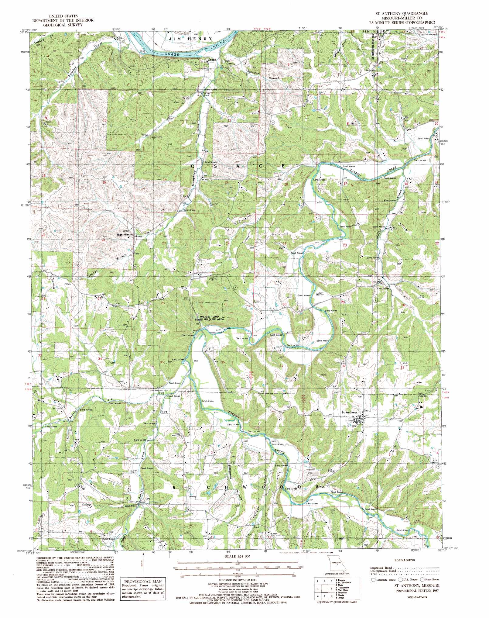
USGS Topo Quad 38092b3 - 1:24,000 scale
| Topo Map Name: | Saint Anthony |
| USGS Topo Quad ID: | 38092b3 |
| Print Size: | ca. 21 1/4" wide x 27" high |
| Southeast Coordinates: | 38.125° N latitude / 92.25° W longitude |
| Map Center Coordinates: | 38.1875° N latitude / 92.3125° W longitude |
| U.S. State: | MO |
| Filename: | o38092b3.jpg |
| Download Map JPG Image: | Saint Anthony topo map 1:24,000 scale |
| Map Type: | Topographic |
| Topo Series: | 7.5´ |
| Map Scale: | 1:24,000 |
| Source of Map Images: | United States Geological Survey (USGS) |
| Alternate Map Versions: |
St. Anthony MO 1987, updated 1988 Download PDF Buy paper map Saint Anthony MO 2011 Download PDF Buy paper map Saint Anthony MO 2015 Download PDF Buy paper map |
1:24,000 Topo Quads surrounding Saint Anthony
Olean |
Enon |
Brazito |
Wardsville |
Westphalia West |
Eldon |
Eugene |
Saint Elizabeth |
Meta |
Argyle |
Bagnell |
Tuscumbia |
Saint Anthony |
Van Cleve |
Brinktown |
Toronto |
Brumley |
Iberia |
Brays |
Big Bend |
Montreal |
Conns Creek |
Crocker |
Hancock |
Dixon |
> Back to 38092a1 at 1:100,000 scale
> Back to 38092a1 at 1:250,000 scale
> Back to U.S. Topo Maps home
Saint Anthony topo map: Gazetteer
Saint Anthony: Islands
Berry Island elevation 168m 551′Saint Anthony: Parks
Wilson Camp State Wildlife Area elevation 259m 849′Saint Anthony: Populated Places
Capps elevation 175m 574′Saint Anthony elevation 287m 941′
Saint Anthony: Streams
Bailey Branch elevation 216m 708′Barren Fork elevation 197m 646′
Brushy Creek elevation 183m 600′
Brushy Fork elevation 195m 639′
Haw Creek elevation 203m 666′
Humphrey Creek elevation 167m 547′
Panther Creek elevation 165m 541′
Pilkinton Branch elevation 199m 652′
Rabbithead Creek elevation 206m 675′
Ramsey Branch elevation 203m 666′
Sullivan Branch elevation 172m 564′
Saint Anthony: Summits
High Point elevation 288m 944′House Mounds elevation 241m 790′
Saint Anthony: Valleys
Heltzell Hollow elevation 213m 698′Saint Anthony digital topo map on disk
Buy this Saint Anthony topo map showing relief, roads, GPS coordinates and other geographical features, as a high-resolution digital map file on DVD: