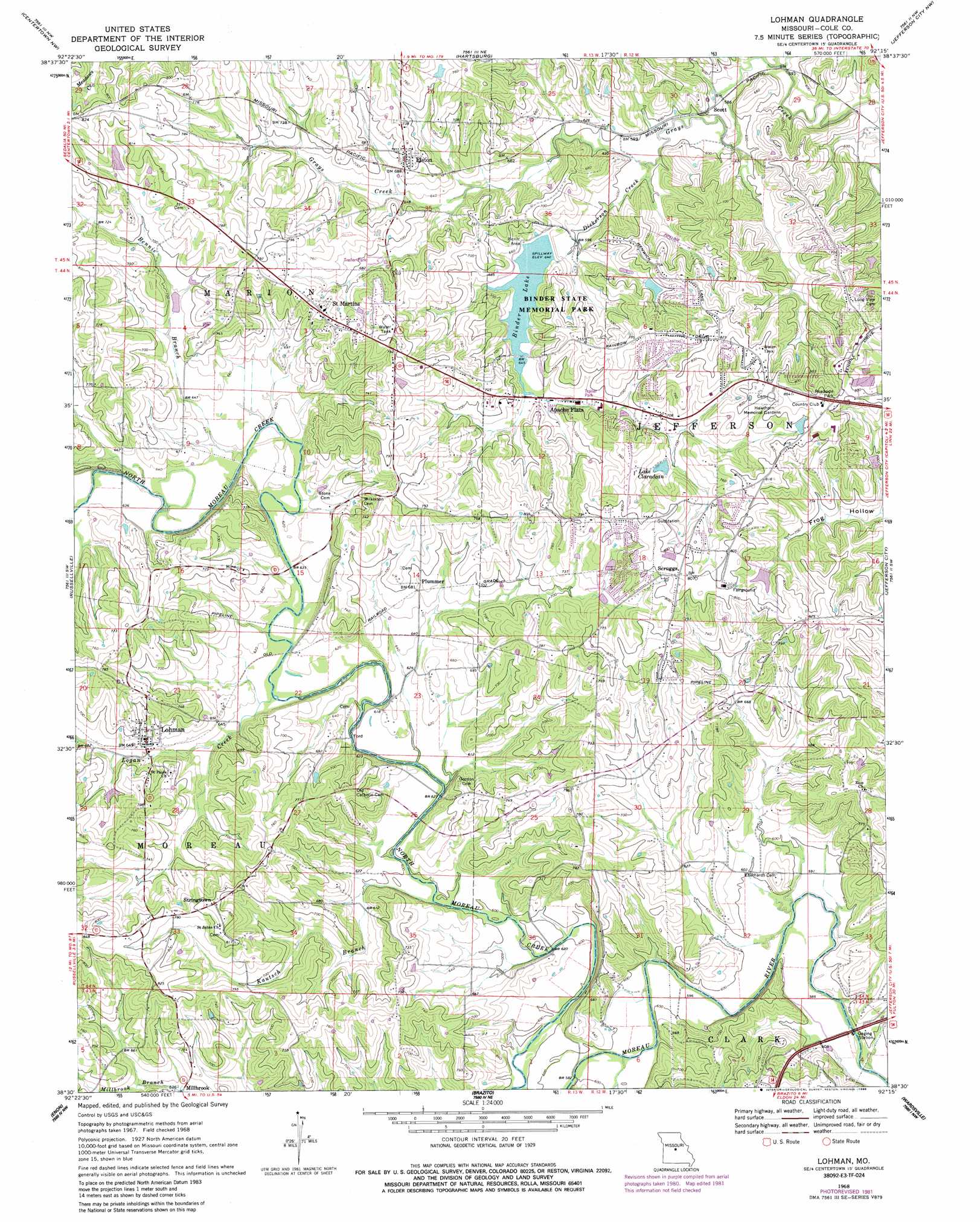
Lohman Topo Map Missouri
To zoom in, hover over the map of Lohman
USGS Topo Quad 38092e3 - 1:24,000 scale
| Topo Map Name: | Lohman |
| USGS Topo Quad ID: | 38092e3 |
| Print Size: | ca. 21 1/4" wide x 27" high |
| Southeast Coordinates: | 38.5° N latitude / 92.25° W longitude |
| Map Center Coordinates: | 38.5625° N latitude / 92.3125° W longitude |
| U.S. State: | MO |
| Filename: | o38092e3.jpg |
| Download Map JPG Image: | Lohman topo map 1:24,000 scale |
| Map Type: | Topographic |
| Topo Series: | 7.5´ |
| Map Scale: | 1:24,000 |
| Source of Map Images: | United States Geological Survey (USGS) |
| Alternate Map Versions: |
Lohman MO 1968, updated 1971 Download PDF Buy paper map Lohman MO 1968, updated 1982 Download PDF Buy paper map Lohman MO 1968, updated 1986 Download PDF Buy paper map Lohman MO 2011 Download PDF Buy paper map Lohman MO 2015 Download PDF Buy paper map |
1:24,000 Topo Quads surrounding Lohman
Prairie Home |
Jamestown |
Ashland |
Millersburg Sw |
Guthrie |
California North |
Centertown Nw |
Hartsburg |
Jefferson City Nw |
New Bloomfield |
California South |
Russellville |
Lohman |
Jefferson City |
Osage City |
Olean |
Enon |
Brazito |
Wardsville |
Westphalia West |
Eldon |
Eugene |
Saint Elizabeth |
Meta |
Argyle |
> Back to 38092e1 at 1:100,000 scale
> Back to 38092a1 at 1:250,000 scale
> Back to U.S. Topo Maps home
Lohman topo map: Gazetteer
Lohman: Bridges
Fish Trap Bridge elevation 182m 597′Hemstreet Bridge elevation 183m 600′
Kohler Bridge elevation 190m 623′
Saddle Bridge elevation 183m 600′
Walser Bridge elevation 183m 600′
Lohman: Dams
Anderson Lake Dam elevation 225m 738′Binder Lake Dam elevation 195m 639′
Lake Claradean Dam elevation 219m 718′
Renns Lake Dam elevation 222m 728′
Woodward Lake Dam elevation 202m 662′
Lohman: Parks
Binder Memorial Park elevation 208m 682′Lohman: Populated Places
Apache Flats elevation 200m 656′Elston elevation 211m 692′
Lohman elevation 204m 669′
Plummer elevation 210m 688′
Saint Martins elevation 237m 777′
Scott elevation 187m 613′
Scruggs elevation 250m 820′
Stringtown elevation 250m 820′
Lohman: Reservoirs
Anderson Lake elevation 225m 738′Binder Lake elevation 195m 639′
Lake Claradean elevation 219m 718′
Woodward Lake elevation 202m 662′
Lohman: Streams
Bennie Branch elevation 188m 616′Dickerson Creek elevation 177m 580′
Kautsch Branch elevation 188m 616′
Logan Creek elevation 183m 600′
South Moreau Creek elevation 183m 600′
Lohman digital topo map on disk
Buy this Lohman topo map showing relief, roads, GPS coordinates and other geographical features, as a high-resolution digital map file on DVD: