Hartsburg Topo Map Missouri
To zoom in, hover over the map of Hartsburg
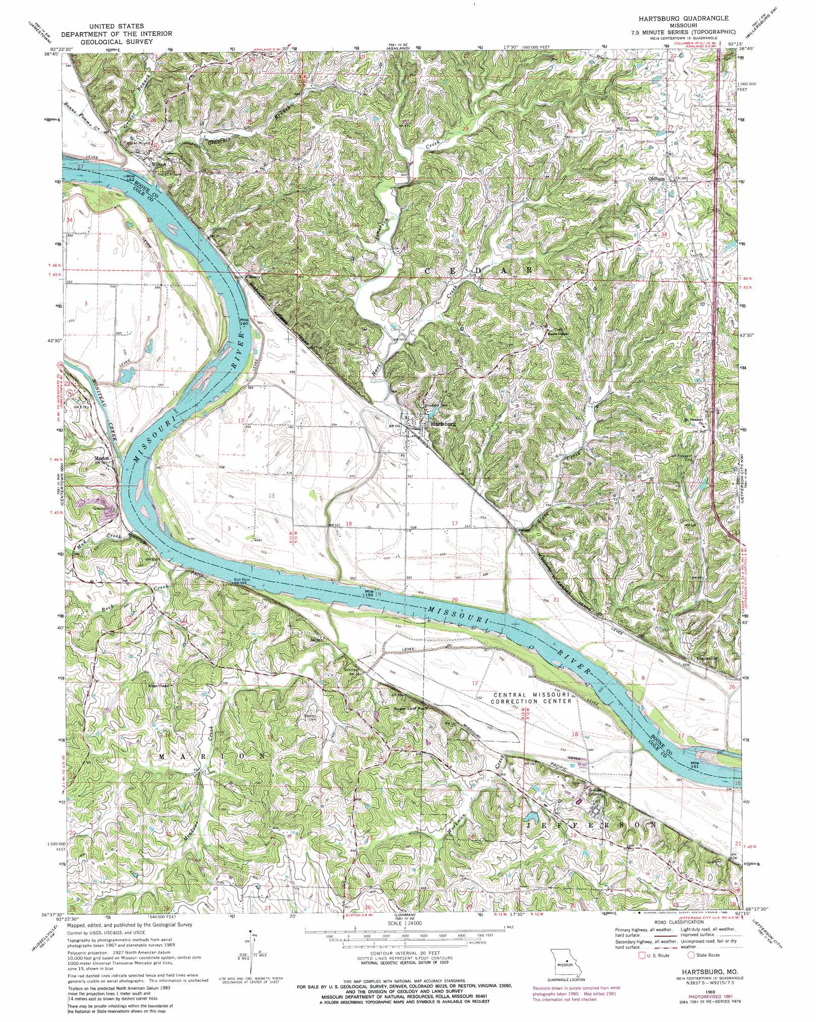
USGS Topo Quad 38092f3 - 1:24,000 scale
| Topo Map Name: | Hartsburg |
| USGS Topo Quad ID: | 38092f3 |
| Print Size: | ca. 21 1/4" wide x 27" high |
| Southeast Coordinates: | 38.625° N latitude / 92.25° W longitude |
| Map Center Coordinates: | 38.6875° N latitude / 92.3125° W longitude |
| U.S. State: | MO |
| Filename: | o38092f3.jpg |
| Download Map JPG Image: | Hartsburg topo map 1:24,000 scale |
| Map Type: | Topographic |
| Topo Series: | 7.5´ |
| Map Scale: | 1:24,000 |
| Source of Map Images: | United States Geological Survey (USGS) |
| Alternate Map Versions: |
Hartsburg MO 1969, updated 1971 Download PDF Buy paper map Hartsburg MO 1969, updated 1982 Download PDF Buy paper map Hartsburg MO 2012 Download PDF Buy paper map Hartsburg MO 2015 Download PDF Buy paper map |
| FStopo: | US Forest Service topo Hartsburg is available: Download FStopo PDF Download FStopo TIF |
1:24,000 Topo Quads surrounding Hartsburg
Rocheport |
Huntsdale |
Columbia |
Millersburg |
Millersburg Ne |
Prairie Home |
Jamestown |
Ashland |
Millersburg Sw |
Guthrie |
California North |
Centertown Nw |
Hartsburg |
Jefferson City Nw |
New Bloomfield |
California South |
Russellville |
Lohman |
Jefferson City |
Osage City |
Olean |
Enon |
Brazito |
Wardsville |
Westphalia West |
> Back to 38092e1 at 1:100,000 scale
> Back to 38092a1 at 1:250,000 scale
> Back to U.S. Topo Maps home
Hartsburg topo map: Gazetteer
Hartsburg: Dams
Church Farm Lake Dam elevation 174m 570′Demarco Lake Dam elevation 206m 675′
Lubker Dam elevation 189m 620′
Hartsburg: Islands
Fox Island elevation 170m 557′Stanley Island elevation 168m 551′
Hartsburg: Pillars
Bull Rock elevation 174m 570′Little Manitou Rock elevation 182m 597′
Sugar Loaf Rock elevation 206m 675′
Hartsburg: Populated Places
Burlington (historical) elevation 170m 557′Claysville elevation 170m 557′
Eureka (historical) elevation 172m 564′
Hartsburg elevation 172m 564′
Marion elevation 177m 580′
Oldham elevation 266m 872′
Stonesport (historical) elevation 168m 551′
Wilton elevation 179m 587′
Hartsburg: Reservoirs
Demarco Lake elevation 206m 675′Hartsburg: Ridges
Little Manitou Rocks elevation 174m 570′Hartsburg: Streams
Bonne Femme Creek elevation 168m 551′Dead Creek (historical) elevation 167m 547′
Glascock Branch elevation 172m 564′
Grider Branch elevation 171m 561′
Hart Creek elevation 167m 547′
Jemerson Creek elevation 171m 561′
Meadows Creek elevation 167m 547′
Moniteau Creek elevation 168m 551′
Mud Creek elevation 168m 551′
Rock Creek elevation 167m 547′
Slate Creek elevation 166m 544′
Workman Creek elevation 170m 557′
Hartsburg digital topo map on disk
Buy this Hartsburg topo map showing relief, roads, GPS coordinates and other geographical features, as a high-resolution digital map file on DVD: