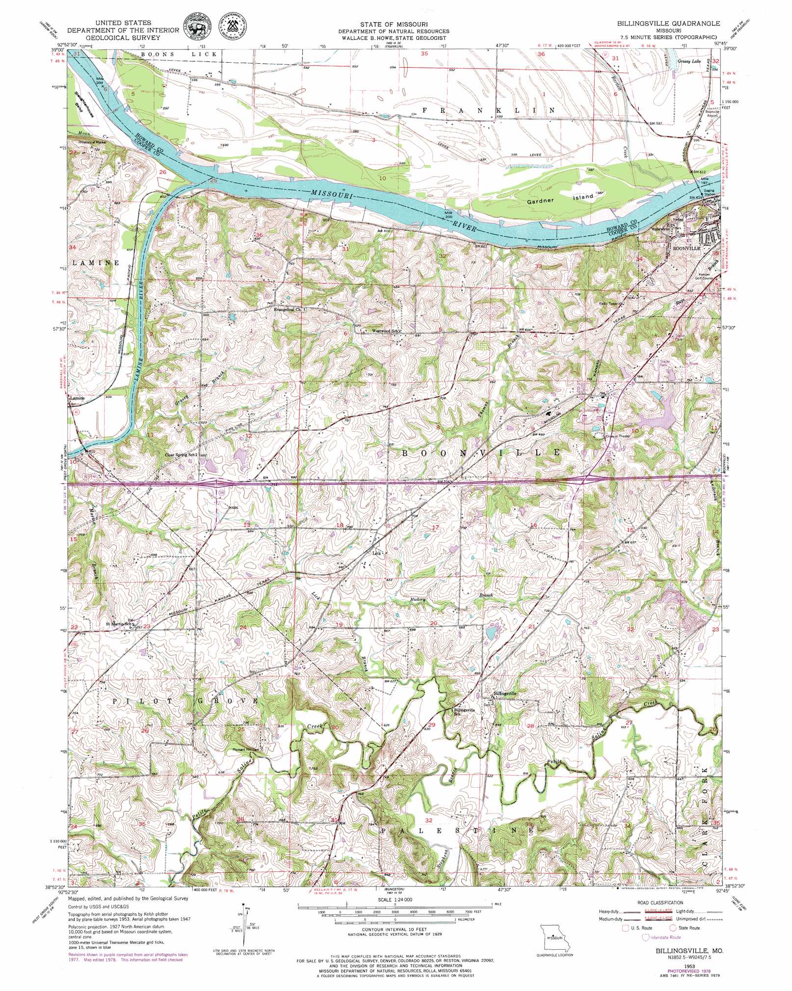
Billingsville Topo Map Missouri
To zoom in, hover over the map of Billingsville
USGS Topo Quad 38092h7 - 1:24,000 scale
| Topo Map Name: | Billingsville |
| USGS Topo Quad ID: | 38092h7 |
| Print Size: | ca. 21 1/4" wide x 27" high |
| Southeast Coordinates: | 38.875° N latitude / 92.75° W longitude |
| Map Center Coordinates: | 38.9375° N latitude / 92.8125° W longitude |
| U.S. State: | MO |
| Filename: | o38092h7.jpg |
| Download Map JPG Image: | Billingsville topo map 1:24,000 scale |
| Map Type: | Topographic |
| Topo Series: | 7.5´ |
| Map Scale: | 1:24,000 |
| Source of Map Images: | United States Geological Survey (USGS) |
| Alternate Map Versions: |
Billingsville MO 1953, updated 1954 Download PDF Buy paper map Billingsville MO 1953, updated 1979 Download PDF Buy paper map Billingsville MO 2011 Download PDF Buy paper map Billingsville MO 2015 Download PDF Buy paper map |
1:24,000 Topo Quads surrounding Billingsville
Slater |
Saline City |
Glasgow |
Fayette |
Burton |
Napton |
Arrow Rock |
Franklin |
New Franklin |
Hilldale |
Nelson |
Pilot Grove North |
Billingsville |
Boonville |
Rocheport |
Clifton City |
Pilot Grove South |
Bunceton |
Lone Elm |
Prairie Home |
Otterville West |
Otterville East |
Tipton |
Clarksburg |
California North |
> Back to 38092e1 at 1:100,000 scale
> Back to 38092a1 at 1:250,000 scale
> Back to U.S. Topo Maps home
Billingsville topo map: Gazetteer
Billingsville: Airports
Boonville Municipal Airport elevation 180m 590′Billingsville: Areas
Gardner Island elevation 180m 590′Billingsville: Bends
Boonville Bends elevation 180m 590′Lamine River Bend elevation 180m 590′
Billingsville: Dams
Friedrich Lake Dam elevation 207m 679′Holtzclaw Lake Dam elevation 209m 685′
Oswald Lake Dam elevation 214m 702′
Schrader Lake Dam elevation 203m 666′
Southwest Dam Number 1 elevation 228m 748′
Trout Dam elevation 232m 761′
Billingsville: Lakes
Grassy Lake elevation 179m 587′Billingsville: Populated Places
Billingsville elevation 199m 652′Lamine elevation 186m 610′
Billingsville: Reservoirs
Friedrich Lake elevation 207m 679′McCoy Number 1 Reservoir elevation 228m 748′
Trout Lake elevation 232m 761′
Billingsville: Streams
Bartlett Creek elevation 180m 590′Grassy Branch elevation 178m 583′
Hickory Branch elevation 192m 629′
Lamine River elevation 180m 590′
Lick Branch elevation 189m 620′
Martin Branch elevation 180m 590′
Moon Creek elevation 181m 593′
Old Channel Salt Creek elevation 180m 590′
Rupe Branch elevation 179m 587′
Stephens Branch elevation 186m 610′
Thomas Branch elevation 180m 590′
Billingsville digital topo map on disk
Buy this Billingsville topo map showing relief, roads, GPS coordinates and other geographical features, as a high-resolution digital map file on DVD: