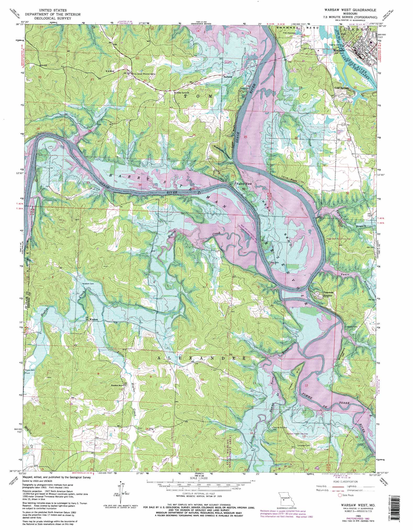
Warsaw West Topo Map Missouri
To zoom in, hover over the map of Warsaw West
USGS Topo Quad 38093b4 - 1:24,000 scale
| Topo Map Name: | Warsaw West |
| USGS Topo Quad ID: | 38093b4 |
| Print Size: | ca. 21 1/4" wide x 27" high |
| Southeast Coordinates: | 38.125° N latitude / 93.375° W longitude |
| Map Center Coordinates: | 38.1875° N latitude / 93.4375° W longitude |
| U.S. State: | MO |
| Filename: | o38093b4.jpg |
| Download Map JPG Image: | Warsaw West topo map 1:24,000 scale |
| Map Type: | Topographic |
| Topo Series: | 7.5´ |
| Map Scale: | 1:24,000 |
| Source of Map Images: | United States Geological Survey (USGS) |
| Alternate Map Versions: |
Warsaw West MO 1965, updated 1966 Download PDF Buy paper map Warsaw West MO 1965, updated 1977 Download PDF Buy paper map Warsaw West MO 1965, updated 1982 Download PDF Buy paper map Warsaw West MO 1965, updated 1982 Download PDF Buy paper map Warsaw West MO 1980, updated 1982 Download PDF Buy paper map Warsaw West MO 2011 Download PDF Buy paper map Warsaw West MO 2015 Download PDF Buy paper map |
1:24,000 Topo Quads surrounding Warsaw West
Calhoun West |
Calhoun East |
Lincoln Nw |
Lincoln |
Cole Camp |
Gaines |
Leesville |
Shawnee Bend |
Lincoln Se |
Lakeview Heights |
Lowry City |
Valhalla |
Warsaw West |
Warsaw East |
Edwards |
Osceola |
Iconium |
Quincy |
Fristoe |
Cross Timbers |
Vista |
Weaubleau |
Wheatland |
Hermitage |
Preston |
> Back to 38093a1 at 1:100,000 scale
> Back to 38092a1 at 1:250,000 scale
> Back to U.S. Topo Maps home
Warsaw West topo map: Gazetteer
Warsaw West: Bends
Peal Bend elevation 215m 705′Warsaw West: Bridges
Bailey Bridge (historical) elevation 215m 705′Heath Bridge (historical) elevation 215m 705′
Peal Bend Bridge (historical) elevation 215m 705′
Warsaw West: Cliffs
Cobb Bluff elevation 215m 705′Laird Bluff elevation 259m 849′
Warsaw West: Dams
Tatge Lake Section 29 Dam elevation 228m 748′Warsaw West: Lakes
Goose Lake (historical) elevation 215m 705′Warsaw West: Parks
Fairfield Public Use Area elevation 246m 807′Osage Bluff Public Use Area elevation 235m 770′
Warsaw West: Populated Places
Cold Springs elevation 211m 692′Fairfield (historical) elevation 215m 705′
Opportunity Farms elevation 264m 866′
Pom-o-sa Heights elevation 243m 797′
Tackner elevation 229m 751′
Valley View elevation 215m 705′
Warsaw elevation 218m 715′
Wisdom elevation 233m 764′
Warsaw West: Streams
Hogles Creek elevation 215m 705′Little Hogles Creek elevation 215m 705′
Little Pomme de Terre River elevation 215m 705′
Pomme de Terre River elevation 215m 705′
Turpin Branch elevation 215m 705′
Vance Branch elevation 215m 705′
Warsaw West: Summits
Indian Hill elevation 258m 846′Mockingbird Hill elevation 245m 803′
Warsaw West: Valleys
Sugarcamp Hollow elevation 215m 705′Warsaw West digital topo map on disk
Buy this Warsaw West topo map showing relief, roads, GPS coordinates and other geographical features, as a high-resolution digital map file on DVD: