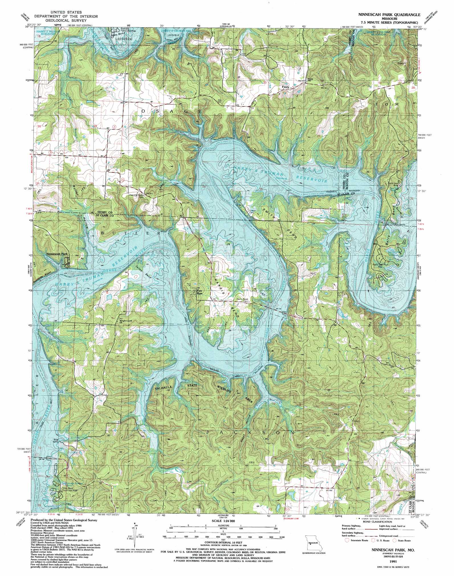
Valhalla Topo Map Missouri
To zoom in, hover over the map of Valhalla
USGS Topo Quad 38093b5 - 1:24,000 scale
| Topo Map Name: | Valhalla |
| USGS Topo Quad ID: | 38093b5 |
| Print Size: | ca. 21 1/4" wide x 27" high |
| Southeast Coordinates: | 38.125° N latitude / 93.5° W longitude |
| Map Center Coordinates: | 38.1875° N latitude / 93.5625° W longitude |
| U.S. State: | MO |
| Filename: | o38093b5.jpg |
| Download Map JPG Image: | Valhalla topo map 1:24,000 scale |
| Map Type: | Topographic |
| Topo Series: | 7.5´ |
| Map Scale: | 1:24,000 |
| Source of Map Images: | United States Geological Survey (USGS) |
| Alternate Map Versions: |
Valhalla MO 1941, updated 1963 Download PDF Buy paper map Valhalla MO 1941, updated 1966 Download PDF Buy paper map Valhalla MO 1945 Download PDF Buy paper map Ninnescah Park MO 1991, updated 1991 Download PDF Buy paper map Ninnescah Park MO 2011 Download PDF Buy paper map Ninnescah Park MO 2014 Download PDF Buy paper map |
1:24,000 Topo Quads surrounding Valhalla
Clinton North |
Calhoun West |
Calhoun East |
Lincoln Nw |
Lincoln |
Clinton South |
Gaines |
Leesville |
Shawnee Bend |
Lincoln Se |
Ohio |
Lowry City |
Valhalla |
Warsaw West |
Warsaw East |
Monegaw Springs |
Osceola |
Iconium |
Quincy |
Fristoe |
Roscoe |
Vista |
Weaubleau |
Wheatland |
Hermitage |
> Back to 38093a1 at 1:100,000 scale
> Back to 38092a1 at 1:250,000 scale
> Back to U.S. Topo Maps home
Valhalla topo map: Gazetteer
Valhalla: Bends
Berry Bend elevation 217m 711′Harris Bend elevation 231m 757′
McGuiness Bend elevation 216m 708′
Smith Bend elevation 229m 751′
Talley Bend elevation 215m 705′
Udo Bend elevation 218m 715′
Valhalla: Islands
Gilbert Island elevation 215m 705′Millers Island elevation 215m 705′
Valhalla: Parks
Berry Bend Public Use Area elevation 222m 728′Valhalla: Populated Places
Baker (historical) elevation 215m 705′Browns Ford elevation 224m 734′
Finey elevation 277m 908′
Fox Run elevation 263m 862′
Ninnescah Park elevation 226m 741′
Valhalla: Springs
Berry Spring elevation 215m 705′White Sulphur Springs elevation 215m 705′
Valhalla: Streams
Big Muddy Creek elevation 215m 705′Jackson Branch elevation 216m 708′
South Fork Wright Creek elevation 240m 787′
Wright Creek elevation 215m 705′
Valhalla: Summits
Buzzards Roost elevation 260m 853′Valhalla: Valleys
Butler Hollow elevation 215m 705′Happy Hollow elevation 215m 705′
Valhalla digital topo map on disk
Buy this Valhalla topo map showing relief, roads, GPS coordinates and other geographical features, as a high-resolution digital map file on DVD: