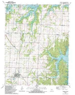
Lowry City Topo Map Missouri
To zoom in, hover over the map of Lowry City
USGS Topo Quad 38093b6 - 1:24,000 scale
| Topo Map Name: | Lowry City |
| USGS Topo Quad ID: | 38093b6 |
| Print Size: | ca. 21 1/4" wide x 27" high |
| Southeast Coordinates: | 38.125° N latitude / 93.625° W longitude |
| Map Center Coordinates: | 38.1875° N latitude / 93.6875° W longitude |
| U.S. State: | MO |
| Filename: | o38093b6.jpg |
| Download Map JPG Image: | Lowry City topo map 1:24,000 scale |
| Map Type: | Topographic |
| Topo Series: | 7.5´ |
| Map Scale: | 1:24,000 |
| Source of Map Images: | United States Geological Survey (USGS) |
| Alternate Map Versions: |
Lowry City MO 1941, updated 1965 Download PDF Buy paper map Lowry City MO 1941, updated 1973 Download PDF Buy paper map Lowry City MO 1941, updated 1983 Download PDF Buy paper map Lowry City MO 1945 Download PDF Buy paper map Lowry City MO 1991, updated 1992 Download PDF Buy paper map Lowry City MO 2011 Download PDF Buy paper map Lowry City MO 2014 Download PDF Buy paper map |
1:24,000 Topo Quads surrounding Lowry City
> Back to 38093a1 at 1:100,000 scale
> Back to 38092a1 at 1:250,000 scale
> Back to U.S. Topo Maps home
Lowry City topo map: Gazetteer
Lowry City: Dams
Ackley Lake Dam elevation 239m 784′Clary Lake Dam elevation 246m 807′
Haverland Lake Dam elevation 257m 843′
Lowry City: Parks
Brownington State Wildlife Area elevation 216m 708′Lowry City: Populated Places
Brownington elevation 228m 748′Chloe elevation 263m 862′
Consville (historical) elevation 230m 754′
Lowry City elevation 266m 872′
Mount Zion elevation 265m 869′
Lowry City: Reservoirs
Ackley Lake elevation 239m 784′Lowry City: Streams
Little Muddy Creek elevation 215m 705′Little Otter Creek elevation 215m 705′
Lowry City: Valleys
Turkey Hollow elevation 215m 705′Lowry City digital topo map on disk
Buy this Lowry City topo map showing relief, roads, GPS coordinates and other geographical features, as a high-resolution digital map file on DVD:


