Shawnee Bend Topo Map Missouri
To zoom in, hover over the map of Shawnee Bend
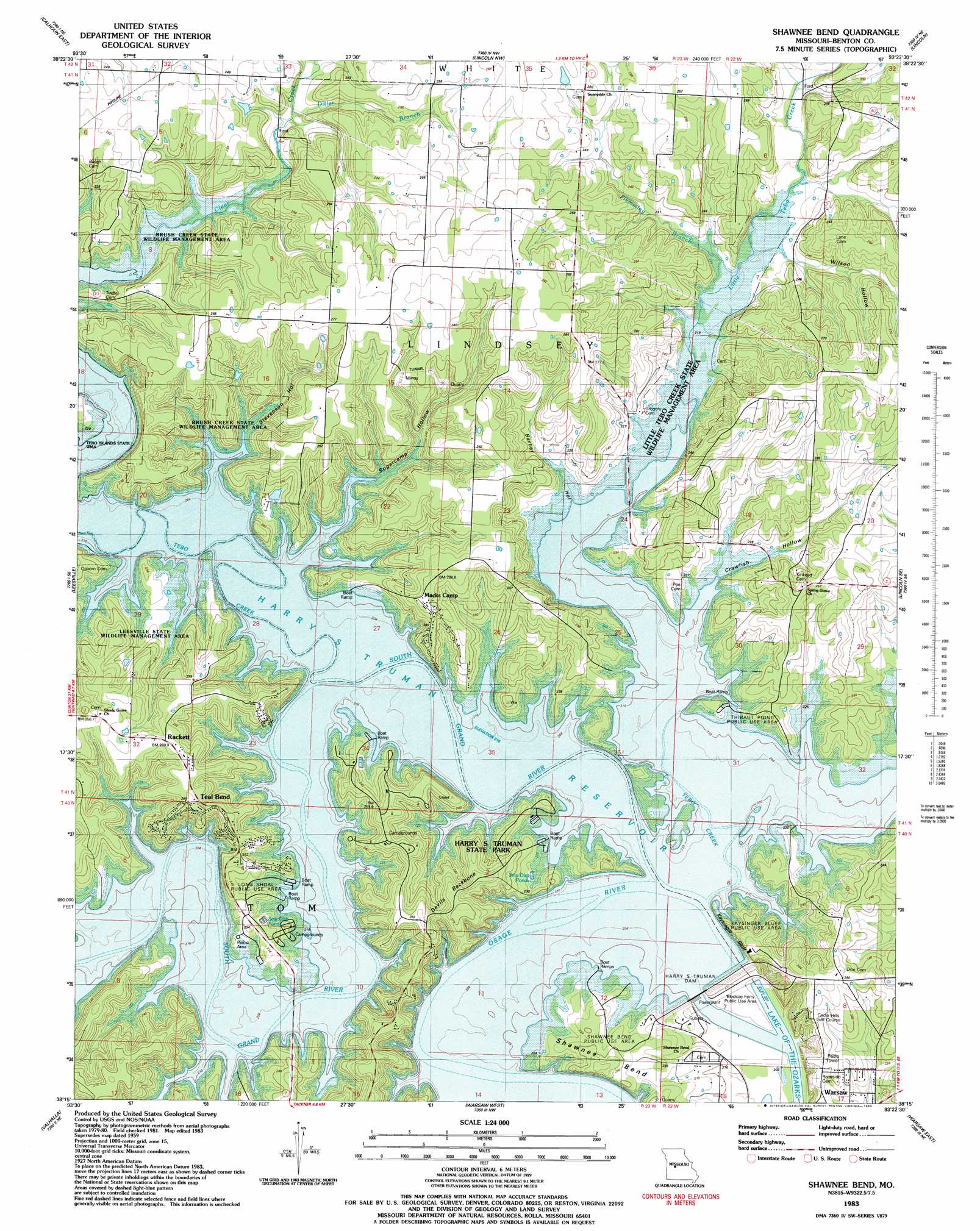
USGS Topo Quad 38093c4 - 1:24,000 scale
| Topo Map Name: | Shawnee Bend |
| USGS Topo Quad ID: | 38093c4 |
| Print Size: | ca. 21 1/4" wide x 27" high |
| Southeast Coordinates: | 38.25° N latitude / 93.375° W longitude |
| Map Center Coordinates: | 38.3125° N latitude / 93.4375° W longitude |
| U.S. State: | MO |
| Filename: | o38093c4.jpg |
| Download Map JPG Image: | Shawnee Bend topo map 1:24,000 scale |
| Map Type: | Topographic |
| Topo Series: | 7.5´ |
| Map Scale: | 1:24,000 |
| Source of Map Images: | United States Geological Survey (USGS) |
| Alternate Map Versions: |
Shawnee Bend MO 1936 Download PDF Buy paper map Shawnee Bend MO 1955, updated 1955 Download PDF Buy paper map Shawnee Bend MO 1959, updated 1960 Download PDF Buy paper map Shawnee Bend MO 1959, updated 1966 Download PDF Buy paper map Shawnee Bend MO 1959, updated 1981 Download PDF Buy paper map Shawnee Bend MO 1980, updated 1982 Download PDF Buy paper map Shawnee Bend MO 1983, updated 1983 Download PDF Buy paper map Shawnee Bend MO 2011 Download PDF Buy paper map Shawnee Bend MO 2014 Download PDF Buy paper map |
1:24,000 Topo Quads surrounding Shawnee Bend
Leeton |
Windsor |
Green Ridge South |
Ionia |
Bahner |
Calhoun West |
Calhoun East |
Lincoln Nw |
Lincoln |
Cole Camp |
Gaines |
Leesville |
Shawnee Bend |
Lincoln Se |
Lakeview Heights |
Lowry City |
Valhalla |
Warsaw West |
Warsaw East |
Edwards |
Osceola |
Iconium |
Quincy |
Fristoe |
Cross Timbers |
> Back to 38093a1 at 1:100,000 scale
> Back to 38092a1 at 1:250,000 scale
> Back to U.S. Topo Maps home
Shawnee Bend topo map: Gazetteer
Shawnee Bend: Bends
Shawnee Bend elevation 226m 741′Shawnee Bend: Bridges
Long Shoal Bridge elevation 215m 705′Shawnee Bend: Cliffs
Kaysinger Bluff elevation 216m 708′Shawnee Bend: Dams
Benson Dam elevation 215m 705′Harry S Truman Dam elevation 250m 820′
Shawnee Bend: Islands
Wrights Island elevation 215m 705′Shawnee Bend: Parks
Bledsoe Ferry Public Use Area elevation 206m 675′Brush Creek State Wildlife Management Area elevation 216m 708′
Harry S Truman State Park elevation 237m 777′
Kaysinger Bluff Public Use Area elevation 241m 790′
Little Tebo Creek State Wildlife Management Area elevation 242m 793′
Long Shoal Public Use Area elevation 217m 711′
Shawnee Bend Public Use Area elevation 240m 787′
Thibaut Point Public Use Area elevation 234m 767′
Shawnee Bend: Populated Places
Macks Camp elevation 264m 866′Racket elevation 257m 843′
Teal Bend elevation 264m 866′
Shawnee Bend: Reservoirs
Benson Lake elevation 215m 705′Harry S Truman Reservoir elevation 250m 820′
Shawnee Bend: Ridges
Devils Backbone elevation 255m 836′Shawnee Bend: Streams
Ditler Creek elevation 231m 757′Flemming Branch elevation 220m 721′
Little Tebo Creek elevation 215m 705′
South Grand River elevation 215m 705′
Sterett Creek elevation 215m 705′
Tebo Creek elevation 215m 705′
Shawnee Bend: Valleys
Barber Hollow elevation 216m 708′Crawfish Hollow elevation 215m 705′
Stevenson Hollow elevation 215m 705′
Sugarcamp Hollow elevation 215m 705′
Sweatman Hollow elevation 228m 748′
Wilson Hollow elevation 225m 738′
Shawnee Bend digital topo map on disk
Buy this Shawnee Bend topo map showing relief, roads, GPS coordinates and other geographical features, as a high-resolution digital map file on DVD: