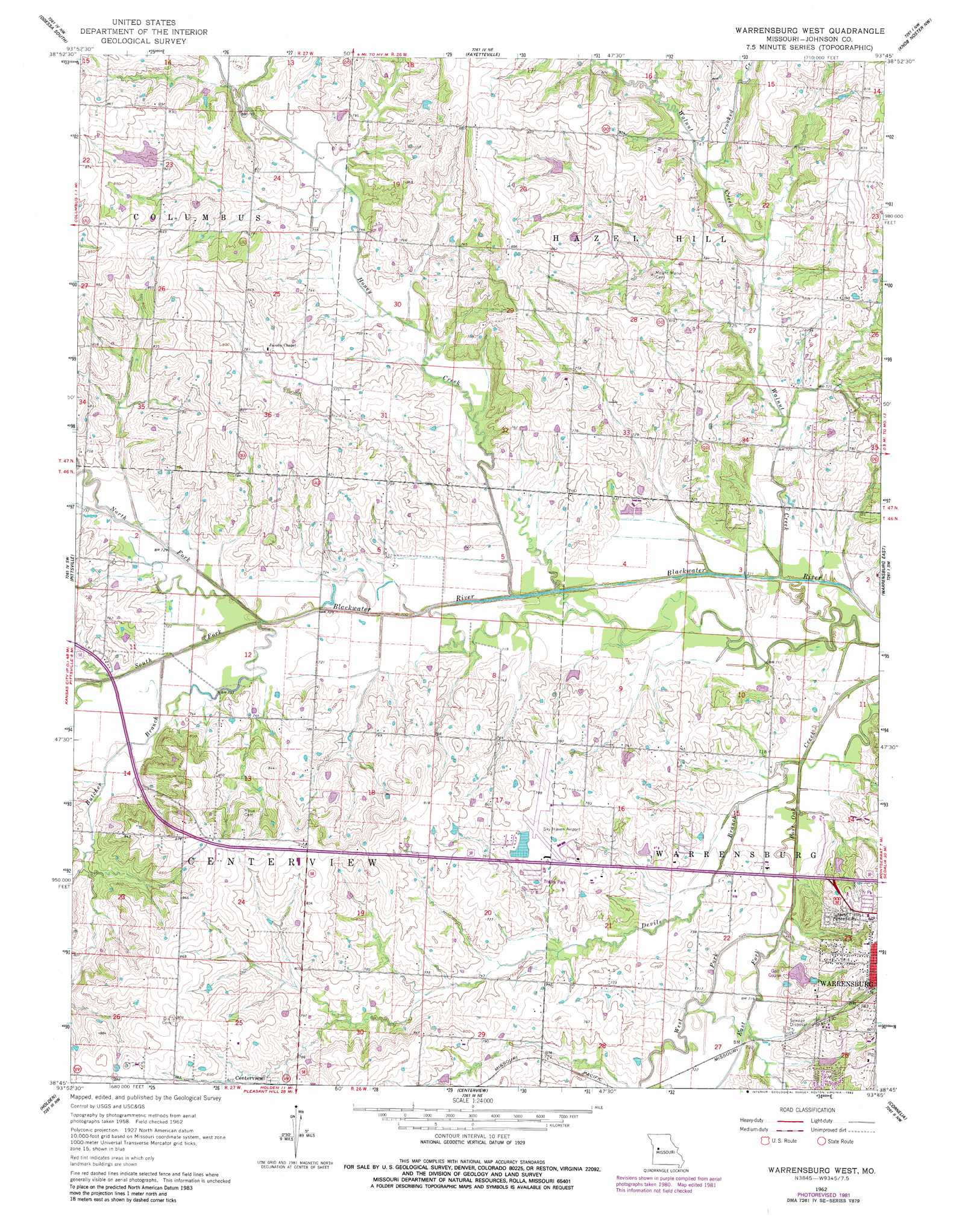
Warrensburg West Topo Map Missouri
To zoom in, hover over the map of Warrensburg West
USGS Topo Quad 38093g7 - 1:24,000 scale
| Topo Map Name: | Warrensburg West |
| USGS Topo Quad ID: | 38093g7 |
| Print Size: | ca. 21 1/4" wide x 27" high |
| Southeast Coordinates: | 38.75° N latitude / 93.75° W longitude |
| Map Center Coordinates: | 38.8125° N latitude / 93.8125° W longitude |
| U.S. State: | MO |
| Filename: | o38093g7.jpg |
| Download Map JPG Image: | Warrensburg West topo map 1:24,000 scale |
| Map Type: | Topographic |
| Topo Series: | 7.5´ |
| Map Scale: | 1:24,000 |
| Source of Map Images: | United States Geological Survey (USGS) |
| Alternate Map Versions: |
Warrensburg West MO 1962, updated 1964 Download PDF Buy paper map Warrensburg West MO 1962, updated 1982 Download PDF Buy paper map Warrensburg West MO 2011 Download PDF Buy paper map Warrensburg West MO 2014 Download PDF Buy paper map |
1:24,000 Topo Quads surrounding Warrensburg West
Bates City |
Odessa North |
Mayview |
Higginsville |
Alma |
Chapel Hill |
Odessa South |
Fayetteville |
Knob Noster Nw |
Concordia |
Elm |
Pittsville |
Warrensburg West |
Warrensburg East |
Knob Noster |
Kingsville |
Holden |
Centerview |
Cornelia |
Burtville |
Quick City |
Blairstown |
Chilhowee |
Leeton |
Windsor |
> Back to 38093e1 at 1:100,000 scale
> Back to 38092a1 at 1:250,000 scale
> Back to U.S. Topo Maps home
Warrensburg West topo map: Gazetteer
Warrensburg West: Airports
Skyhaven Airport elevation 241m 790′Warrensburg West: Dams
Hamilton Lake Dam elevation 224m 734′Maxson Lake Dam elevation 242m 793′
Skyhaven Lake Dam elevation 238m 780′
Warrensburg Country Club Lake Dam elevation 219m 718′
Yukon Lake Dam elevation 249m 816′
Warrensburg West: Populated Places
Greendoor elevation 238m 780′Warrensburg West: Post Offices
Greendoor Post Office (historical) elevation 238m 780′Warrensburg West: Reservoirs
Hamilton Lake elevation 224m 734′Maxson Lake elevation 242m 793′
Sky Haven Lake elevation 238m 780′
Warrensburg West: Streams
Butcher Branch elevation 213m 698′Crooked Creek elevation 224m 734′
Devils Branch elevation 211m 692′
East Fork Post Oak Creek elevation 211m 692′
Honey Creek elevation 210m 688′
North Fork Blackwater River elevation 212m 695′
South Fork Blackwater River elevation 216m 708′
Walnut Creek elevation 210m 688′
West Fork Post Oak Creek elevation 211m 692′
Warrensburg West digital topo map on disk
Buy this Warrensburg West topo map showing relief, roads, GPS coordinates and other geographical features, as a high-resolution digital map file on DVD: