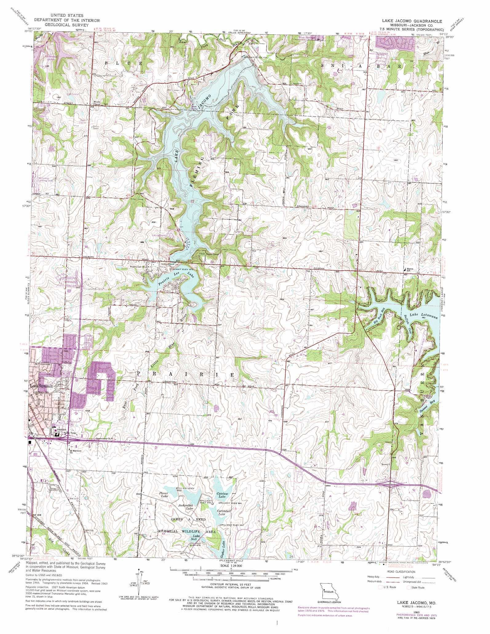
Lake Jacomo Topo Map Missouri
To zoom in, hover over the map of Lake Jacomo
USGS Topo Quad 38094h3 - 1:24,000 scale
| Topo Map Name: | Lake Jacomo |
| USGS Topo Quad ID: | 38094h3 |
| Print Size: | ca. 21 1/4" wide x 27" high |
| Southeast Coordinates: | 38.875° N latitude / 94.25° W longitude |
| Map Center Coordinates: | 38.9375° N latitude / 94.3125° W longitude |
| U.S. State: | MO |
| Filename: | o38094h3.jpg |
| Download Map JPG Image: | Lake Jacomo topo map 1:24,000 scale |
| Map Type: | Topographic |
| Topo Series: | 7.5´ |
| Map Scale: | 1:24,000 |
| Source of Map Images: | United States Geological Survey (USGS) |
| Alternate Map Versions: |
Woods Chapel MO 1934 Download PDF Buy paper map Woods Chapel MO 1934, updated 1955 Download PDF Buy paper map Woods Chapel MO 1957, updated 1958 Download PDF Buy paper map Lake Jacomo MO 1963, updated 1964 Download PDF Buy paper map Lake Jacomo MO 1963, updated 1970 Download PDF Buy paper map Lake Jacomo MO 1963, updated 1976 Download PDF Buy paper map Lake Jacomo MO 1990, updated 1995 Download PDF Buy paper map Lake Jacomo MO 1996, updated 2002 Download PDF Buy paper map Lake Jacomo MO 2011 Download PDF Buy paper map Lake Jacomo MO 2015 Download PDF Buy paper map |
1:24,000 Topo Quads surrounding Lake Jacomo
North Kansas City |
Liberty |
Missouri City |
Buckner |
Camden |
Kansas City |
Independence |
Blue Springs |
Oak Grove |
Bates City |
Grandview |
Lees Summit |
Lake Jacomo |
Tarsney Lakes |
Chapel Hill |
Belton |
Raymore |
Pleasant Hill |
Strasburg |
Elm |
West Line |
Peculiar |
Harrisonville |
East Lynne |
Kingsville |
> Back to 38094e1 at 1:100,000 scale
> Back to 38094a1 at 1:250,000 scale
> Back to U.S. Topo Maps home
Lake Jacomo topo map: Gazetteer
Lake Jacomo: Airports
McComas-Lees Summit Municipal Airport elevation 303m 994′Radio Control Flying Field elevation 285m 935′
Stafford Airport elevation 294m 964′
Lake Jacomo: Bays
Big Rock Bay elevation 269m 882′Buffalo Cove elevation 268m 879′
Ligget Cove elevation 254m 833′
Sailboat Cove elevation 254m 833′
Sunset Bay elevation 268m 879′
Lake Jacomo: Crossings
Interchange 10A and 10B elevation 302m 990′Interchange 12 elevation 287m 941′
Lake Jacomo: Dams
Barber Lake Dam elevation 306m 1003′Catclaw Lake Dam elevation 299m 980′
Chapel Woods Golf Course Lake Dam elevation 285m 935′
Christiansen Lake Dam elevation 280m 918′
Cottontail Lake Dam elevation 289m 948′
Jackrabbit Lake Dam elevation 299m 980′
Lake Jacomo Dam elevation 255m 836′
Lake Nell Dam elevation 299m 980′
Lone Summit Lake Dam elevation 303m 994′
Plover Lake Dam elevation 305m 1000′
Prairie Lee Lake Dam elevation 263m 862′
Lake Jacomo: Parks
Fleming East Nature Preserve elevation 267m 875′Fleming Park elevation 258m 846′
Franke Soccer Fields elevation 290m 951′
James A Reed Memorial Wildlife Area elevation 302m 990′
North Prairie Lee Park elevation 260m 853′
South Prairie Lee Park elevation 280m 918′
Lake Jacomo: Post Offices
R B Rice Post Office elevation 293m 961′Lake Jacomo: Reservoirs
Catclaws Lake elevation 301m 987′Christiansen Lake elevation 280m 918′
Cottontail Lake elevation 289m 948′
Jackrabbit Lake elevation 299m 980′
Lake Jacomo elevation 255m 836′
Lake Nell elevation 299m 980′
Lakewood Lakes elevation 265m 869′
Number 38 Lake elevation 303m 994′
Plover Lake elevation 305m 1000′
Prairie Lee Lake elevation 263m 862′
Reed Area Number 8 Lake elevation 299m 980′
Lake Jacomo digital topo map on disk
Buy this Lake Jacomo topo map showing relief, roads, GPS coordinates and other geographical features, as a high-resolution digital map file on DVD: