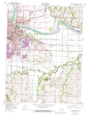
Lawrence East Topo Map Kansas
To zoom in, hover over the map of Lawrence East
USGS Topo Quad 38095h2 - 1:24,000 scale
| Topo Map Name: | Lawrence East |
| USGS Topo Quad ID: | 38095h2 |
| Print Size: | ca. 21 1/4" wide x 27" high |
| Southeast Coordinates: | 38.875° N latitude / 95.125° W longitude |
| Map Center Coordinates: | 38.9375° N latitude / 95.1875° W longitude |
| U.S. State: | KS |
| Filename: | o38095h2.jpg |
| Download Map JPG Image: | Lawrence East topo map 1:24,000 scale |
| Map Type: | Topographic |
| Topo Series: | 7.5´ |
| Map Scale: | 1:24,000 |
| Source of Map Images: | United States Geological Survey (USGS) |
| Alternate Map Versions: |
Lawrence East KS 1950, updated 1952 Download PDF Buy paper map Lawrence East KS 1950, updated 1952 Download PDF Buy paper map Lawrence East KS 1950, updated 1968 Download PDF Buy paper map Lawrence East KS 1950, updated 1978 Download PDF Buy paper map Lawrence East KS 2009 Download PDF Buy paper map Lawrence East KS 2012 Download PDF Buy paper map Lawrence East KS 2015 Download PDF Buy paper map |
1:24,000 Topo Quads surrounding Lawrence East
> Back to 38095e1 at 1:100,000 scale
> Back to 38094a1 at 1:250,000 scale
> Back to U.S. Topo Maps home
Lawrence East topo map: Gazetteer
Lawrence East: Airports
Gage Farm Airport elevation 258m 846′Lawrence East: Lakes
Potter Lake elevation 289m 948′Lawrence East: Parks
Central Park elevation 255m 836′Clinton Park elevation 253m 830′
Edgewater Parkway elevation 261m 856′
Haskell Indian Nations University - Haskell Stadium elevation 270m 885′
South Park elevation 264m 866′
University of Kansas - Lawrence Campus Marvin Grove elevation 290m 951′
University of Kansas - Lawrence Campus Stadium Memorial Kivisto Field elevation 275m 902′
University Park elevation 295m 967′
Lawrence East: Populated Places
Bismark Grove elevation 250m 820′Broken Arrow Park elevation 256m 839′
Brookwood Mobile Home Park elevation 265m 869′
Harper Woods Mobile Home Park elevation 282m 925′
Lawrence elevation 264m 866′
Noria elevation 248m 813′
Riverside Mobile Home Park elevation 251m 823′
Sibleyville elevation 251m 823′
Lawrence East: Post Offices
Lawrence Post Office elevation 260m 853′Lawrence East: Streams
Burroughs Creek elevation 243m 797′Coal Creek elevation 247m 810′
Little Wakarusa Creek elevation 240m 787′
Mud Creek elevation 241m 790′
Spring Creek elevation 244m 800′
Lawrence East: Summits
Blue Mound elevation 321m 1053′Lawrence East digital topo map on disk
Buy this Lawrence East topo map showing relief, roads, GPS coordinates and other geographical features, as a high-resolution digital map file on DVD:


