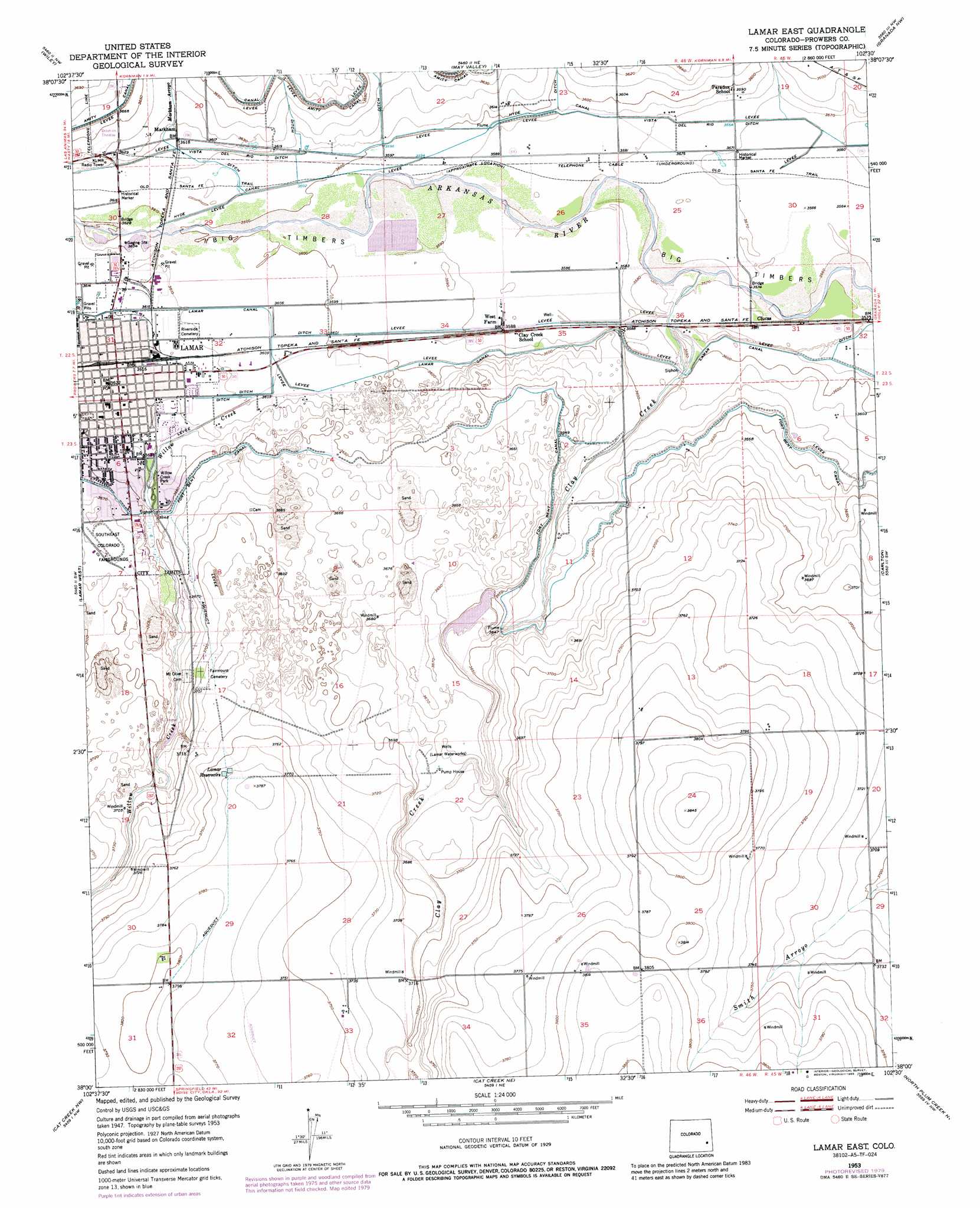
Lamar East Topo Map Colorado
To zoom in, hover over the map of Lamar East
USGS Topo Quad 38102a5 - 1:24,000 scale
| Topo Map Name: | Lamar East |
| USGS Topo Quad ID: | 38102a5 |
| Print Size: | ca. 21 1/4" wide x 27" high |
| Southeast Coordinates: | 38° N latitude / 102.5° W longitude |
| Map Center Coordinates: | 38.0625° N latitude / 102.5625° W longitude |
| U.S. State: | CO |
| Filename: | o38102a5.jpg |
| Download Map JPG Image: | Lamar East topo map 1:24,000 scale |
| Map Type: | Topographic |
| Topo Series: | 7.5´ |
| Map Scale: | 1:24,000 |
| Source of Map Images: | United States Geological Survey (USGS) |
| Alternate Map Versions: |
Lamar East CO 1953, updated 1954 Download PDF Buy paper map Lamar East CO 1953, updated 1977 Download PDF Buy paper map Lamar East CO 1953, updated 1979 Download PDF Buy paper map Lamar East CO 1953, updated 1985 Download PDF Buy paper map Lamar East CO 2010 Download PDF Buy paper map Lamar East CO 2013 Download PDF Buy paper map Lamar East CO 2016 Download PDF Buy paper map |
1:24,000 Topo Quads surrounding Lamar East
Swede Lake |
Neenoshe Reservoir |
Chivington Se |
Sheridan Lake Sw |
Sheridan Lake Se |
Mcclave |
Wiley |
May Valley |
Granada Nw |
Granada Ne |
Prowers |
Lamar West |
Lamar East |
Carlton |
Granada |
Denny Lake |
Cat Creek Nw |
Cat Creek Ne |
North Plum Creek Nw |
North Plum Creek Ne |
Dripping Spring |
Cat Creek |
Gobblers Knob |
Barrel Spring |
North Plum Creek Se |
> Back to 38102a1 at 1:100,000 scale
> Back to 38102a1 at 1:250,000 scale
> Back to U.S. Topo Maps home
Lamar East topo map: Gazetteer
Lamar East: Canals
Hyde Canal elevation 1096m 3595′Vista Del Rio Ditch elevation 1094m 3589′
Lamar East: Parks
Mike Higbee State Wildlife Area elevation 1101m 3612′Lamar East: Populated Places
Lamar elevation 1103m 3618′West Farm elevation 1094m 3589′
Lamar East: Reservoirs
Lamar Reservoirs elevation 1148m 3766′Lamar East: Streams
Clay Creek elevation 1089m 3572′Markham Arroyo elevation 1104m 3622′
Lamar East digital topo map on disk
Buy this Lamar East topo map showing relief, roads, GPS coordinates and other geographical features, as a high-resolution digital map file on DVD: