Mount Tyndall Topo Map Colorado
To zoom in, hover over the map of Mount Tyndall
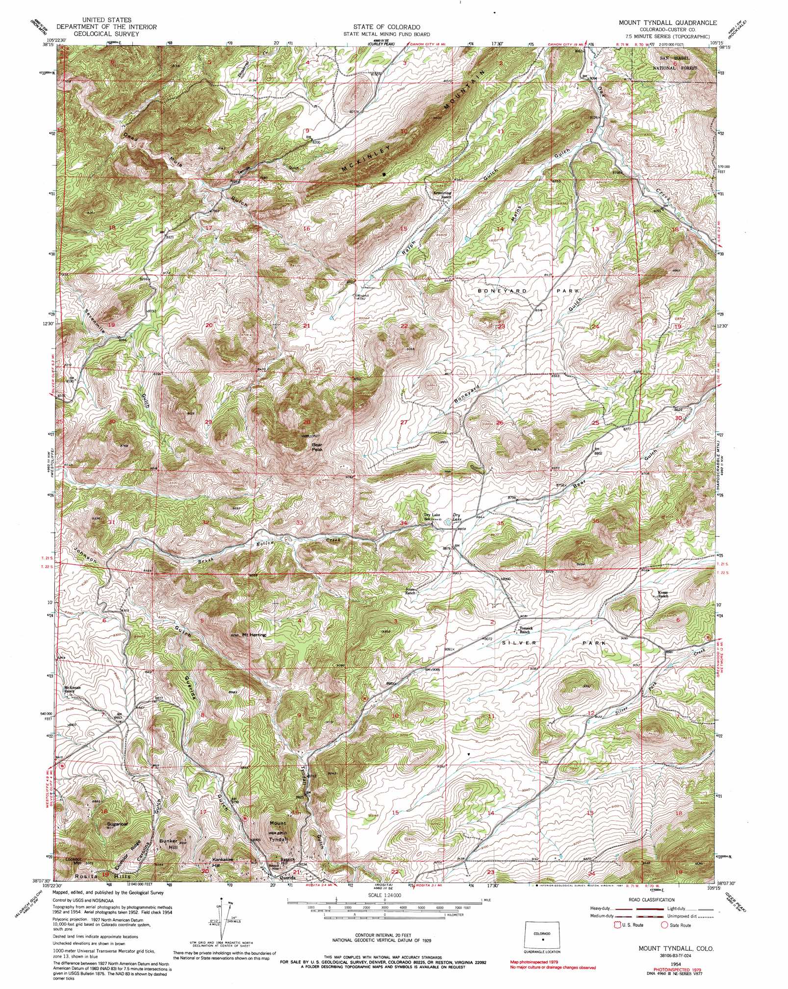
USGS Topo Quad 38105b3 - 1:24,000 scale
| Topo Map Name: | Mount Tyndall |
| USGS Topo Quad ID: | 38105b3 |
| Print Size: | ca. 21 1/4" wide x 27" high |
| Southeast Coordinates: | 38.125° N latitude / 105.25° W longitude |
| Map Center Coordinates: | 38.1875° N latitude / 105.3125° W longitude |
| U.S. State: | CO |
| Filename: | o38105b3.jpg |
| Download Map JPG Image: | Mount Tyndall topo map 1:24,000 scale |
| Map Type: | Topographic |
| Topo Series: | 7.5´ |
| Map Scale: | 1:24,000 |
| Source of Map Images: | United States Geological Survey (USGS) |
| Alternate Map Versions: |
Mount Tyndall CO 1954, updated 1956 Download PDF Buy paper map Mount Tyndall CO 1954, updated 1966 Download PDF Buy paper map Mount Tyndall CO 1954, updated 1966 Download PDF Buy paper map Mount Tyndall CO 1954, updated 1972 Download PDF Buy paper map Mount Tyndall CO 1954, updated 1972 Download PDF Buy paper map Mount Tyndall CO 1954, updated 1991 Download PDF Buy paper map Mount Tyndall CO 1994, updated 1998 Download PDF Buy paper map Mount Tyndall CO 2011 Download PDF Buy paper map Mount Tyndall CO 2013 Download PDF Buy paper map Mount Tyndall CO 2016 Download PDF Buy paper map |
| FStopo: | US Forest Service topo Mount Tyndall is available: Download FStopo PDF Download FStopo TIF |
1:24,000 Topo Quads surrounding Mount Tyndall
Echo |
Mcintyre Hills |
Royal Gorge |
Canon City |
Florence |
Hillside |
Iron Mountain |
Curley Peak |
Rockvale |
Florence Se |
Beckwith Mountain |
Westcliffe |
Mount Tyndall |
Hardscrabble Mountain |
Wetmore |
Horn Peak |
Aldrich Gulch |
Rosita |
Deer Peak |
Saint Charles Peak |
Crestone Peak |
Beck Mountain |
Devils Gulch |
Bear Creek |
San Isabel |
> Back to 38105a1 at 1:100,000 scale
> Back to 38104a1 at 1:250,000 scale
> Back to U.S. Topo Maps home
Mount Tyndall topo map: Gazetteer
Mount Tyndall: Flats
Boneyard Park elevation 2580m 8464′Silver Park elevation 2756m 9041′
Mount Tyndall: Lakes
Dry Lake elevation 2695m 8841′Mount Tyndall: Mines
Antrim Claim elevation 2802m 9192′Bassick Mine elevation 2782m 9127′
Big Stake Nickel Mine elevation 2750m 9022′
Derby Extension Mine elevation 2338m 7670′
Feldspar Lode elevation 2649m 8690′
General Ike Mine elevation 2584m 8477′
Georgia Mine elevation 2750m 9022′
Haputa Ranch Mine elevation 2775m 9104′
John Spalding Mine elevation 2561m 8402′
Lee Jones Ranch Mine elevation 2678m 8786′
Lucky Find Mine elevation 2521m 8270′
Lucky Strike Mine elevation 2657m 8717′
Mystery Mine elevation 2539m 8330′
Nightingale Claim elevation 2786m 9140′
Oak Creek Mine elevation 2513m 8244′
Penny Poker Mine elevation 2406m 7893′
Pocahontas Mine elevation 2698m 8851′
Robinson-Young-Marjorie Lode Mine elevation 2731m 8959′
Sparling Ranch Mine elevation 2631m 8631′
Starbuck Mine elevation 2521m 8270′
Thorium Mountain Mine elevation 2584m 8477′
Tomsick Mine elevation 2742m 8996′
Wet Mountain Mine elevation 2602m 8536′
Mount Tyndall: Populated Places
Querida elevation 2739m 8986′Mount Tyndall: Ridges
Excelsior Ridge elevation 2760m 9055′McKinley Mountain elevation 2544m 8346′
Mount Tyndall: Streams
Brush Hollow Creek elevation 2487m 8159′Mount Tyndall: Summits
Bassick Hill elevation 2801m 9189′Bear Peak elevation 2922m 9586′
Bunker Hill elevation 2837m 9307′
Kankakee Hill elevation 2828m 9278′
Lookout Mountain elevation 2856m 9370′
Mount Herring elevation 2821m 9255′
Mount Tyndall elevation 2882m 9455′
Sugarloaf elevation 2770m 9087′
Mount Tyndall: Valleys
Boneyard Gulch elevation 2503m 8211′Cottonwood Gulch elevation 2744m 9002′
Mains Gulch elevation 2481m 8139′
Querida Gulch elevation 2540m 8333′
Tenmile Gulch elevation 2403m 7883′
Tyndall Gulch elevation 2607m 8553′
Mount Tyndall digital topo map on disk
Buy this Mount Tyndall topo map showing relief, roads, GPS coordinates and other geographical features, as a high-resolution digital map file on DVD: