Westcliffe Topo Map Colorado
To zoom in, hover over the map of Westcliffe
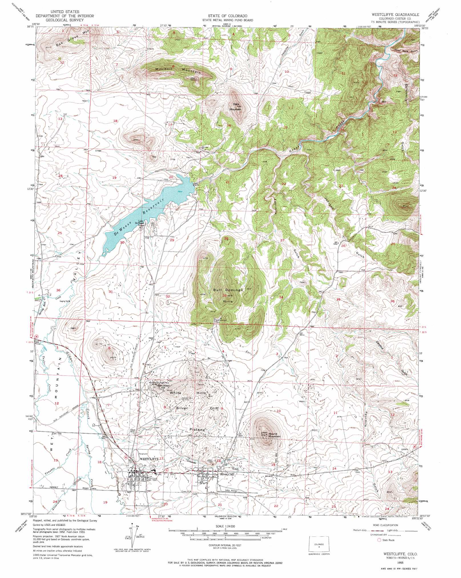
USGS Topo Quad 38105b4 - 1:24,000 scale
| Topo Map Name: | Westcliffe |
| USGS Topo Quad ID: | 38105b4 |
| Print Size: | ca. 21 1/4" wide x 27" high |
| Southeast Coordinates: | 38.125° N latitude / 105.375° W longitude |
| Map Center Coordinates: | 38.1875° N latitude / 105.4375° W longitude |
| U.S. State: | CO |
| Filename: | o38105b4.jpg |
| Download Map JPG Image: | Westcliffe topo map 1:24,000 scale |
| Map Type: | Topographic |
| Topo Series: | 7.5´ |
| Map Scale: | 1:24,000 |
| Source of Map Images: | United States Geological Survey (USGS) |
| Alternate Map Versions: |
Westcliffe CO 1955, updated 1957 Download PDF Buy paper map Westcliffe CO 1955, updated 1957 Download PDF Buy paper map Westcliffe CO 1955, updated 1969 Download PDF Buy paper map Westcliffe CO 1955, updated 1974 Download PDF Buy paper map Westcliffe CO 2010 Download PDF Buy paper map Westcliffe CO 2013 Download PDF Buy paper map Westcliffe CO 2016 Download PDF Buy paper map |
1:24,000 Topo Quads surrounding Westcliffe
Arkansas Mountain |
Echo |
Mcintyre Hills |
Royal Gorge |
Canon City |
Cotopaxi |
Hillside |
Iron Mountain |
Curley Peak |
Rockvale |
Electric Peak |
Beckwith Mountain |
Westcliffe |
Mount Tyndall |
Hardscrabble Mountain |
Rito Alto Peak |
Horn Peak |
Aldrich Gulch |
Rosita |
Deer Peak |
Crestone |
Crestone Peak |
Beck Mountain |
Devils Gulch |
Bear Creek |
> Back to 38105a1 at 1:100,000 scale
> Back to 38104a1 at 1:250,000 scale
> Back to U.S. Topo Maps home
Westcliffe topo map: Gazetteer
Westcliffe: Airports
Dan Riggs Memorial Heliport elevation 2405m 7890′Westcliffe: Dams
De Weese Dam elevation 2338m 7670′Westcliffe: Mines
Bull Domingo Mine elevation 2521m 8270′C H Connor Mine elevation 2423m 7949′
Deceiver Mine elevation 2425m 7956′
Defender Mine elevation 2450m 8038′
Green Mountain Mine elevation 2392m 7847′
Herman Passiflora Mine elevation 2420m 7939′
Keystone Mine elevation 2439m 8001′
Lady Franklin Mine elevation 2469m 8100′
Lakeview Mine elevation 2501m 8205′
New Hope Mine elevation 2425m 7956′
Nutter Prospect elevation 2408m 7900′
Quist Voss Land Mine elevation 2392m 7847′
Stroelhke Mine elevation 2380m 7808′
Wahl Mine elevation 2425m 7956′
Westcliffe: Populated Places
Silver Cliff elevation 2434m 7985′Westcliffe elevation 2398m 7867′
Westcliffe: Reservoirs
Deweese-Dye Reservoir elevation 2338m 7670′Westcliffe: Streams
Alvarado Creek elevation 2376m 7795′Luton Creek elevation 2358m 7736′
Spring Creek elevation 2365m 7759′
Spring Run elevation 2357m 7732′
Swift Creek elevation 2349m 7706′
Taylor Creek elevation 2355m 7726′
Venable Creek elevation 2371m 7778′
Westcliffe: Summits
Ben West Hill elevation 2479m 8133′Bull Domingo Hills elevation 2548m 8359′
Dora Mountain elevation 2549m 8362′
Mitchell Mountain elevation 2563m 8408′
Oak Grove Mountain elevation 2493m 8179′
Round Mountain elevation 2464m 8083′
Silver Cliff Plateau elevation 2489m 8166′
White Hills elevation 2537m 8323′
Westcliffe: Valleys
Carolina Gulch elevation 2419m 7936′Chloride Gulch elevation 2384m 7821′
Dead Mule Gulch elevation 2249m 7378′
Fourmile Gulch elevation 2303m 7555′
Johnson Gulch elevation 2299m 7542′
Sevenmile Gulch elevation 2254m 7395′
Westcliffe digital topo map on disk
Buy this Westcliffe topo map showing relief, roads, GPS coordinates and other geographical features, as a high-resolution digital map file on DVD: