Iron Mountain Topo Map Colorado
To zoom in, hover over the map of Iron Mountain
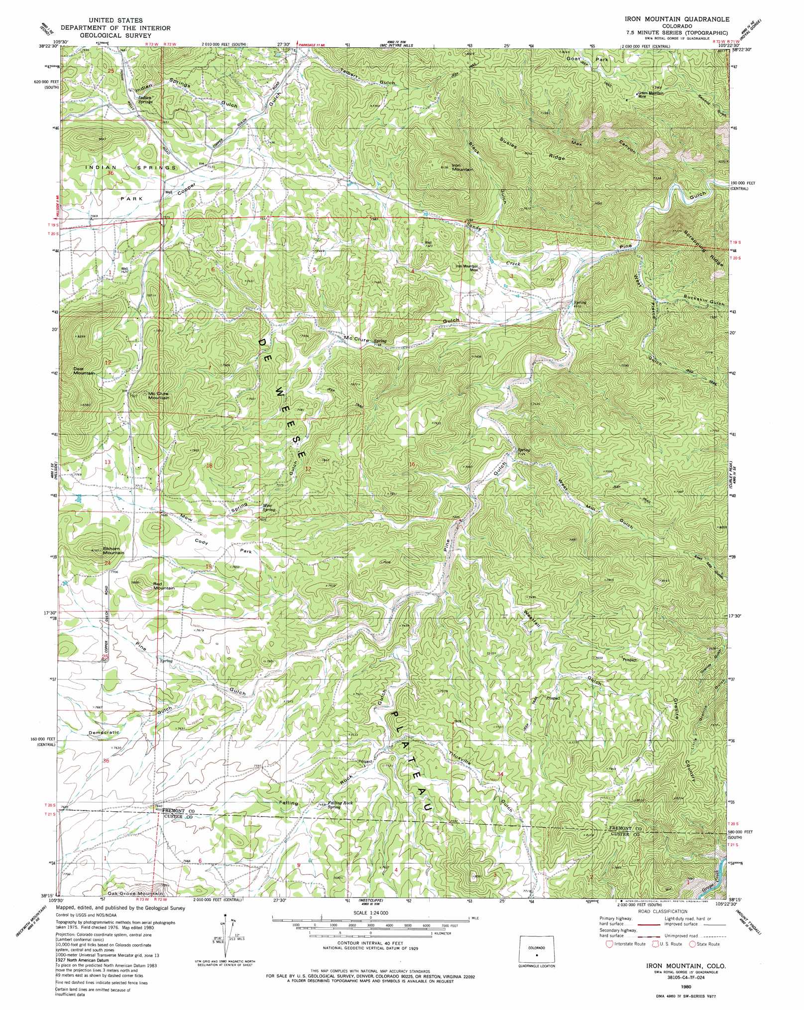
USGS Topo Quad 38105c4 - 1:24,000 scale
| Topo Map Name: | Iron Mountain |
| USGS Topo Quad ID: | 38105c4 |
| Print Size: | ca. 21 1/4" wide x 27" high |
| Southeast Coordinates: | 38.25° N latitude / 105.375° W longitude |
| Map Center Coordinates: | 38.3125° N latitude / 105.4375° W longitude |
| U.S. State: | CO |
| Filename: | o38105c4.jpg |
| Download Map JPG Image: | Iron Mountain topo map 1:24,000 scale |
| Map Type: | Topographic |
| Topo Series: | 7.5´ |
| Map Scale: | 1:24,000 |
| Source of Map Images: | United States Geological Survey (USGS) |
| Alternate Map Versions: |
Iron Mountain CO 1980, updated 1981 Download PDF Buy paper map Iron Mountain CO 1980, updated 1982 Download PDF Buy paper map Iron Mountain CO 1980, updated 1985 Download PDF Buy paper map Iron Mountain CO 1980, updated 1985 Download PDF Buy paper map Iron Mountain CO 2010 Download PDF Buy paper map Iron Mountain CO 2013 Download PDF Buy paper map Iron Mountain CO 2016 Download PDF Buy paper map |
1:24,000 Topo Quads surrounding Iron Mountain
Waugh Mountain |
Hall Gulch |
Gribble Mountain |
Rice Mountain |
Cooper Mountain |
Arkansas Mountain |
Echo |
Mcintyre Hills |
Royal Gorge |
Canon City |
Cotopaxi |
Hillside |
Iron Mountain |
Curley Peak |
Rockvale |
Electric Peak |
Beckwith Mountain |
Westcliffe |
Mount Tyndall |
Hardscrabble Mountain |
Rito Alto Peak |
Horn Peak |
Aldrich Gulch |
Rosita |
Deer Peak |
> Back to 38105a1 at 1:100,000 scale
> Back to 38104a1 at 1:250,000 scale
> Back to U.S. Topo Maps home
Iron Mountain topo map: Gazetteer
Iron Mountain: Areas
Granite Country elevation 2405m 7890′Iron Mountain: Flats
Cody Park elevation 2335m 7660′Indian Springs Park elevation 2323m 7621′
Iron Mountain: Gaps
Copper Gulch Divide elevation 2417m 7929′Iron Mountain: Mines
Brown Lava Lode Mine elevation 2293m 7522′Copper Girl Mine elevation 2296m 7532′
Green Mountain Mine elevation 2259m 7411′
Green Mountain Mine elevation 2421m 7942′
Iron Mountain Mine elevation 2184m 7165′
Iron Mountain: Ridges
Susies Ridge elevation 2463m 8080′Iron Mountain: Springs
Deadhorse Spring elevation 2276m 7467′Falling Rock Spring elevation 2284m 7493′
Indian Springs elevation 2319m 7608′
Mow Spring elevation 2311m 7582′
Iron Mountain: Streams
Sandy Creek elevation 2108m 6916′Iron Mountain: Summits
Deer Mountain elevation 2586m 8484′Elkhorn Mountain elevation 2468m 8097′
Iron Mountain elevation 2463m 8080′
McClure Mountain elevation 2475m 8120′
Red Mountain elevation 2374m 7788′
Iron Mountain: Valleys
Black Gulch elevation 2108m 6916′Buckskin Gulch elevation 2145m 7037′
Falling Rock Gulch elevation 2210m 7250′
Indian Springs Gulch elevation 2265m 7431′
Max Canyon elevation 2021m 6630′
McClure Gulch elevation 2141m 7024′
Mow Spring Gulch elevation 2202m 7224′
Talbert Gulch elevation 2242m 7355′
Titusville Gulch elevation 2256m 7401′
West Mill Gulch elevation 2180m 7152′
West Pierce Gulch elevation 2082m 6830′
Westfall Gulch elevation 2203m 7227′
Iron Mountain digital topo map on disk
Buy this Iron Mountain topo map showing relief, roads, GPS coordinates and other geographical features, as a high-resolution digital map file on DVD: