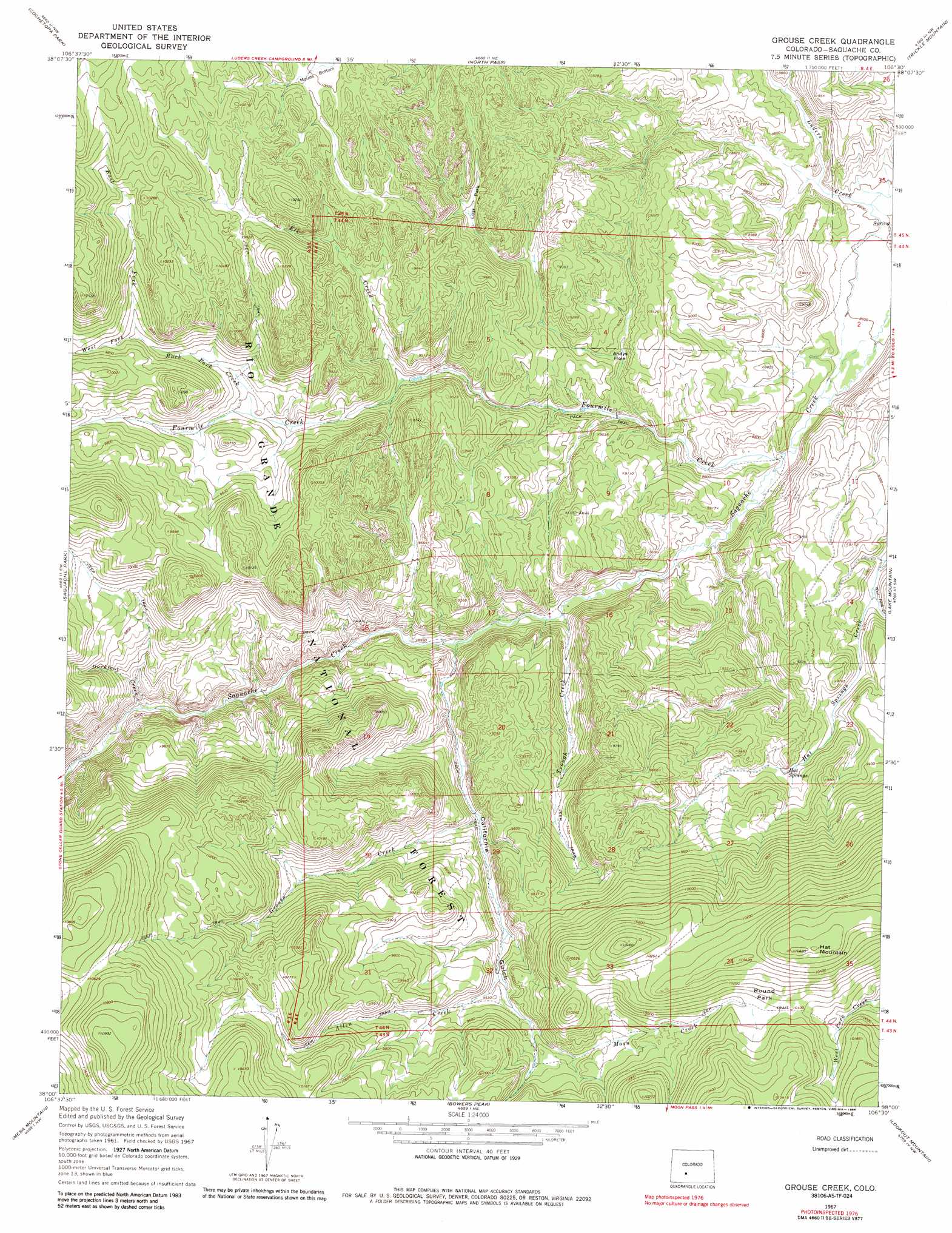
Grouse Creek Topo Map Colorado
To zoom in, hover over the map of Grouse Creek
USGS Topo Quad 38106a5 - 1:24,000 scale
| Topo Map Name: | Grouse Creek |
| USGS Topo Quad ID: | 38106a5 |
| Print Size: | ca. 21 1/4" wide x 27" high |
| Southeast Coordinates: | 38° N latitude / 106.5° W longitude |
| Map Center Coordinates: | 38.0625° N latitude / 106.5625° W longitude |
| U.S. State: | CO |
| Filename: | o38106a5.jpg |
| Download Map JPG Image: | Grouse Creek topo map 1:24,000 scale |
| Map Type: | Topographic |
| Topo Series: | 7.5´ |
| Map Scale: | 1:24,000 |
| Source of Map Images: | United States Geological Survey (USGS) |
| Alternate Map Versions: |
Grouse Creek CO 1967, updated 1969 Download PDF Buy paper map Grouse Creek CO 1967, updated 1969 Download PDF Buy paper map Grouse Creek CO 1967, updated 1984 Download PDF Buy paper map Grouse Creek CO 2001, updated 2005 Download PDF Buy paper map Grouse Creek CO 2011 Download PDF Buy paper map Grouse Creek CO 2013 Download PDF Buy paper map Grouse Creek CO 2016 Download PDF Buy paper map |
| FStopo: | US Forest Service topo Grouse Creek is available: Download FStopo PDF Download FStopo TIF |
1:24,000 Topo Quads surrounding Grouse Creek
Sawtooth Mountain |
Razor Creek Dome |
West Baldy |
Sargents Mesa |
Chester |
Cold Spring Park |
Cochetopa Park |
North Pass |
Trickle Mountain |
Lake Mountain Ne |
Elk Park |
Saguache Park |
Grouse Creek |
Lake Mountain |
Laughlin Gulch |
Halfmoon Pass |
Mesa Mountain |
Bowers Peak |
Lookout Mountain |
Lime Creek |
Wagon Wheel Gap |
Pool Table Mountain |
Pine Cone Knob |
Twin Mountains |
Twin Mountains Se |
> Back to 38106a1 at 1:100,000 scale
> Back to 38106a1 at 1:250,000 scale
> Back to U.S. Topo Maps home
Grouse Creek topo map: Gazetteer
Grouse Creek: Bends
Andys Hole elevation 2717m 8914′Grouse Creek: Flats
Mouds Bottom elevation 2989m 9806′Round Park elevation 3103m 10180′
Grouse Creek: Springs
Hat Springs elevation 2806m 9206′Grouse Creek: Streams
Allen Creek elevation 2866m 9402′Buck Park Creek elevation 2871m 9419′
Duckfoot Creek elevation 2773m 9097′
East Fork Buck Park Creek elevation 2961m 9714′
Elk Creek elevation 2797m 9176′
Fourmile Creek elevation 2641m 8664′
Grouse Creek elevation 2807m 9209′
Moon Creek elevation 2908m 9540′
Trough Creek elevation 2685m 8809′
West Fork Buck Park Creek elevation 2961m 9714′
West Park Creek elevation 2716m 8910′
Grouse Creek: Summits
Hat Mountain elevation 3235m 10613′Grouse Creek: Valleys
California Gulch elevation 2707m 8881′Grouse Creek digital topo map on disk
Buy this Grouse Creek topo map showing relief, roads, GPS coordinates and other geographical features, as a high-resolution digital map file on DVD: