Stewart Peak Topo Map Colorado
To zoom in, hover over the map of Stewart Peak
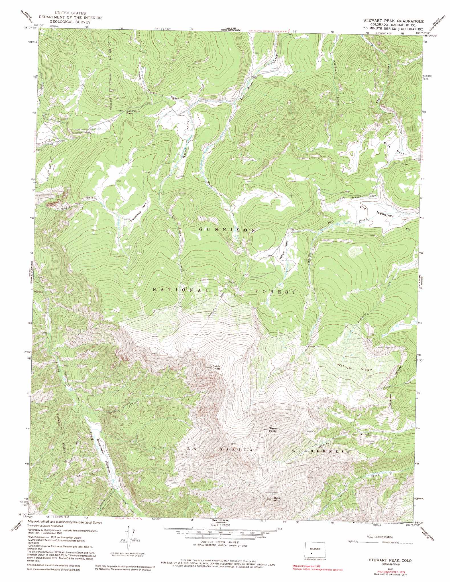
USGS Topo Quad 38106a8 - 1:24,000 scale
| Topo Map Name: | Stewart Peak |
| USGS Topo Quad ID: | 38106a8 |
| Print Size: | ca. 21 1/4" wide x 27" high |
| Southeast Coordinates: | 38° N latitude / 106.875° W longitude |
| Map Center Coordinates: | 38.0625° N latitude / 106.9375° W longitude |
| U.S. State: | CO |
| Filename: | o38106a8.jpg |
| Download Map JPG Image: | Stewart Peak topo map 1:24,000 scale |
| Map Type: | Topographic |
| Topo Series: | 7.5´ |
| Map Scale: | 1:24,000 |
| Source of Map Images: | United States Geological Survey (USGS) |
| Alternate Map Versions: |
Stewart Peak CO 1965, updated 1968 Download PDF Buy paper map Stewart Peak CO 1965, updated 1975 Download PDF Buy paper map Stewart Peak CO 1965, updated 1991 Download PDF Buy paper map Stewart Peak CO 2001, updated 2004 Download PDF Buy paper map Stewart Peak CO 2011 Download PDF Buy paper map Stewart Peak CO 2013 Download PDF Buy paper map Stewart Peak CO 2016 Download PDF Buy paper map |
| FStopo: | US Forest Service topo Stewart Peak is available: Download FStopo PDF Download FStopo TIF |
1:24,000 Topo Quads surrounding Stewart Peak
Gateview |
Powderhorn |
Spring Hill Creek |
Sawtooth Mountain |
Razor Creek Dome |
Powderhorn Lakes |
Rudolph Hill |
Rock Creek Park |
Cold Spring Park |
Cochetopa Park |
Cannibal Plateau |
Mineral Mountain |
Stewart Peak |
Elk Park |
Saguache Park |
Slumgullion Pass |
Baldy Cinco |
San Luis Peak |
Halfmoon Pass |
Mesa Mountain |
Hermit Lakes |
Bristol Head |
Creede |
Wagon Wheel Gap |
Pool Table Mountain |
> Back to 38106a1 at 1:100,000 scale
> Back to 38106a1 at 1:250,000 scale
> Back to U.S. Topo Maps home
Stewart Peak topo map: Gazetteer
Stewart Peak: Canals
Cochetopa Meadows Ditch elevation 3319m 10889′Stewart Peak: Flats
Big Meadows elevation 3288m 10787′Blue Park elevation 3274m 10741′
Bondholder Meadows elevation 3078m 10098′
Groundhog Park elevation 3279m 10757′
Horsefly Park elevation 3205m 10515′
Sage Park elevation 3102m 10177′
Willow Park elevation 3450m 11318′
Stewart Peak: Gaps
Los Pinos Pass elevation 3203m 10508′Stewart Peak: Ranges
La Garita Mountains elevation 4253m 13953′Stewart Peak: Streams
Cascade Creek elevation 3081m 10108′East Fork Los Pinos Creek elevation 3024m 9921′
Sheep Creek elevation 3025m 9924′
Stewart Peak: Summits
Baldy Alto elevation 4177m 13704′Baldy Chato elevation 4083m 13395′
Stewart Peak elevation 4253m 13953′
Willow Mesa elevation 3772m 12375′
Stewart Peak: Trails
Bondholder Trail elevation 2988m 9803′Cebolla Stock Driveway elevation 3464m 11364′
Stewart Creek Trail elevation 3435m 11269′
Stewart Peak: Valleys
Porcupine Gulch elevation 3066m 10059′Stewart Peak digital topo map on disk
Buy this Stewart Peak topo map showing relief, roads, GPS coordinates and other geographical features, as a high-resolution digital map file on DVD: