Spring Hill Creek Topo Map Colorado
To zoom in, hover over the map of Spring Hill Creek
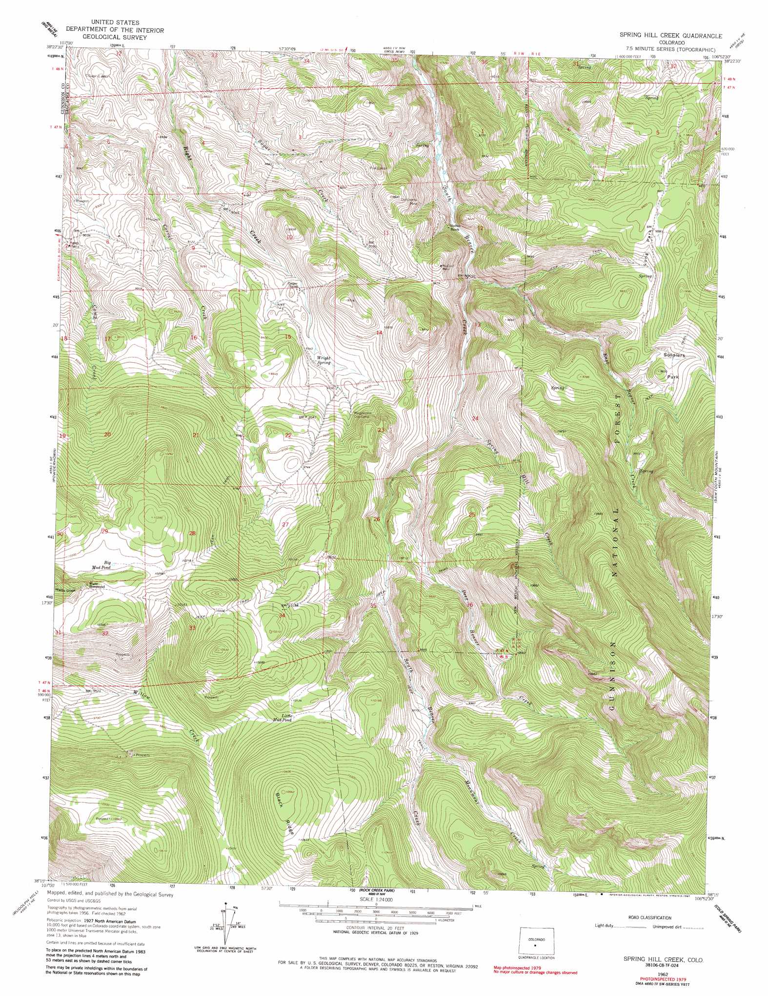
USGS Topo Quad 38106c8 - 1:24,000 scale
| Topo Map Name: | Spring Hill Creek |
| USGS Topo Quad ID: | 38106c8 |
| Print Size: | ca. 21 1/4" wide x 27" high |
| Southeast Coordinates: | 38.25° N latitude / 106.875° W longitude |
| Map Center Coordinates: | 38.3125° N latitude / 106.9375° W longitude |
| U.S. State: | CO |
| Filename: | o38106c8.jpg |
| Download Map JPG Image: | Spring Hill Creek topo map 1:24,000 scale |
| Map Type: | Topographic |
| Topo Series: | 7.5´ |
| Map Scale: | 1:24,000 |
| Source of Map Images: | United States Geological Survey (USGS) |
| Alternate Map Versions: |
Spring Hill Creek CO 1962, updated 1964 Download PDF Buy paper map Spring Hill Creek CO 1962, updated 1964 Download PDF Buy paper map Spring Hill Creek CO 1962, updated 1973 Download PDF Buy paper map Spring Hill Creek CO 1962, updated 1985 Download PDF Buy paper map Spring Hill Creek CO 1962, updated 1987 Download PDF Buy paper map Spring Hill Creek CO 2001, updated 2004 Download PDF Buy paper map Spring Hill Creek CO 2011 Download PDF Buy paper map Spring Hill Creek CO 2013 Download PDF Buy paper map Spring Hill Creek CO 2016 Download PDF Buy paper map |
| FStopo: | US Forest Service topo Spring Hill Creek is available: Download FStopo PDF Download FStopo TIF |
1:24,000 Topo Quads surrounding Spring Hill Creek
West Elk Peak Sw |
Mcintosh Mountain |
Gunnison |
Signal Peak |
Parlin |
Carpenter Ridge |
Big Mesa |
Iris Nw |
Iris |
Houston Gulch |
Gateview |
Powderhorn |
Spring Hill Creek |
Sawtooth Mountain |
Razor Creek Dome |
Powderhorn Lakes |
Rudolph Hill |
Rock Creek Park |
Cold Spring Park |
Cochetopa Park |
Cannibal Plateau |
Mineral Mountain |
Stewart Peak |
Elk Park |
Saguache Park |
> Back to 38106a1 at 1:100,000 scale
> Back to 38106a1 at 1:250,000 scale
> Back to U.S. Topo Maps home
Spring Hill Creek topo map: Gazetteer
Spring Hill Creek: Flats
Long Park elevation 3001m 9845′Soldiers Park elevation 2982m 9783′
Spring Hill Creek: Lakes
Big Mud Pond elevation 3132m 10275′Little Mud Pond elevation 3075m 10088′
Spring Hill Creek: Mines
Continental Mine elevation 2820m 9251′Midland Mine elevation 2896m 9501′
Willow Creek Group Mine elevation 3011m 9878′
Spring Hill Creek: Ridges
Black Ridge elevation 3215m 10547′Spring Hill Creek: Springs
Right Spring elevation 2849m 9347′Spring Hill Creek: Streams
Deer Beaver Creek elevation 2836m 9304′East Beaver Creek elevation 2744m 9002′
Monument Creek elevation 2997m 9832′
Right Creek elevation 2652m 8700′
Spring Hill Creek elevation 2805m 9202′
Spring Hill Creek digital topo map on disk
Buy this Spring Hill Creek topo map showing relief, roads, GPS coordinates and other geographical features, as a high-resolution digital map file on DVD: