Mount Ouray Topo Map Colorado
To zoom in, hover over the map of Mount Ouray
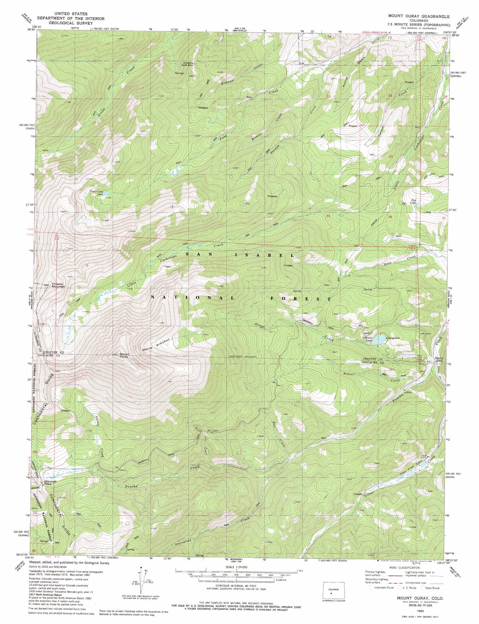
USGS Topo Quad 38106d2 - 1:24,000 scale
| Topo Map Name: | Mount Ouray |
| USGS Topo Quad ID: | 38106d2 |
| Print Size: | ca. 21 1/4" wide x 27" high |
| Southeast Coordinates: | 38.375° N latitude / 106.125° W longitude |
| Map Center Coordinates: | 38.4375° N latitude / 106.1875° W longitude |
| U.S. State: | CO |
| Filename: | o38106d2.jpg |
| Download Map JPG Image: | Mount Ouray topo map 1:24,000 scale |
| Map Type: | Topographic |
| Topo Series: | 7.5´ |
| Map Scale: | 1:24,000 |
| Source of Map Images: | United States Geological Survey (USGS) |
| Alternate Map Versions: |
Mount Ouray CO 1980, updated 1981 Download PDF Buy paper map Mount Ouray CO 1980, updated 1981 Download PDF Buy paper map Mount Ouray CO 1980, updated 1986 Download PDF Buy paper map Mount Ouray CO 1980, updated 1986 Download PDF Buy paper map Mount Ouray CO 1980, updated 1988 Download PDF Buy paper map Mount Ouray CO 1994, updated 1998 Download PDF Buy paper map Mount Ouray CO 2011 Download PDF Buy paper map Mount Ouray CO 2013 Download PDF Buy paper map Mount Ouray CO 2016 Download PDF Buy paper map |
| FStopo: | US Forest Service topo Mount Ouray is available: Download FStopo PDF Download FStopo TIF |
1:24,000 Topo Quads surrounding Mount Ouray
Cumberland Pass |
Saint Elmo |
Mount Antero |
Nathrop |
Cameron Mountain |
Whitepine |
Garfield |
Maysville |
Salida West |
Salida East |
Sargents |
Pahlone Peak |
Mount Ouray |
Poncha Pass |
Wellsville |
Sargents Mesa |
Chester |
Bonanza |
Whale Hill |
Bushnell Peak |
Trickle Mountain |
Lake Mountain Ne |
Klondike Mine |
Graveyard Gulch |
Villa Grove |
> Back to 38106a1 at 1:100,000 scale
> Back to 38106a1 at 1:250,000 scale
> Back to U.S. Topo Maps home
Mount Ouray topo map: Gazetteer
Mount Ouray: Basins
Devils Armchair elevation 3625m 11893′Mount Ouray: Dams
Grays Creek Dam elevation 2783m 9130′O Haver Lake Dam elevation 2783m 9130′
Mount Ouray: Gaps
Marshall Pass elevation 3317m 10882′Mount Ouray: Lakes
Dry Lake elevation 2827m 9274′O'Haver Lake elevation 2783m 9130′
Pass Creek Lake elevation 3459m 11348′
Silver Creek Lakes elevation 2711m 8894′
Mount Ouray: Mines
Bonita Group Mine elevation 2937m 9635′Cinderella South Mine elevation 3202m 10505′
Valley View Mine elevation 2803m 9196′
Mount Ouray: Populated Places
Shirley (historical) elevation 2644m 8674′Mount Ouray: Reservoirs
Lake O'Haver elevation 2783m 9130′Mount Ouray: Streams
Beaver Creek elevation 2649m 8690′Box Creek elevation 2761m 9058′
Browns Creek elevation 2772m 9094′
Grays Creek elevation 2640m 8661′
Ouray Creek elevation 3292m 10800′
Silver Creek elevation 2640m 8661′
Spruce Creek elevation 2476m 8123′
Starvation Creek elevation 2768m 9081′
Stumpy Creek elevation 2670m 8759′
Tent Creek elevation 2894m 9494′
Mount Ouray: Summits
Chipeta Mountain elevation 3894m 12775′Mount Ouray elevation 4233m 13887′
Mount Ouray: Valleys
Dry Lake Gulch elevation 2489m 8166′Hunter Gulch elevation 2584m 8477′
Mount Ouray digital topo map on disk
Buy this Mount Ouray topo map showing relief, roads, GPS coordinates and other geographical features, as a high-resolution digital map file on DVD: