Pahlone Peak Topo Map Colorado
To zoom in, hover over the map of Pahlone Peak
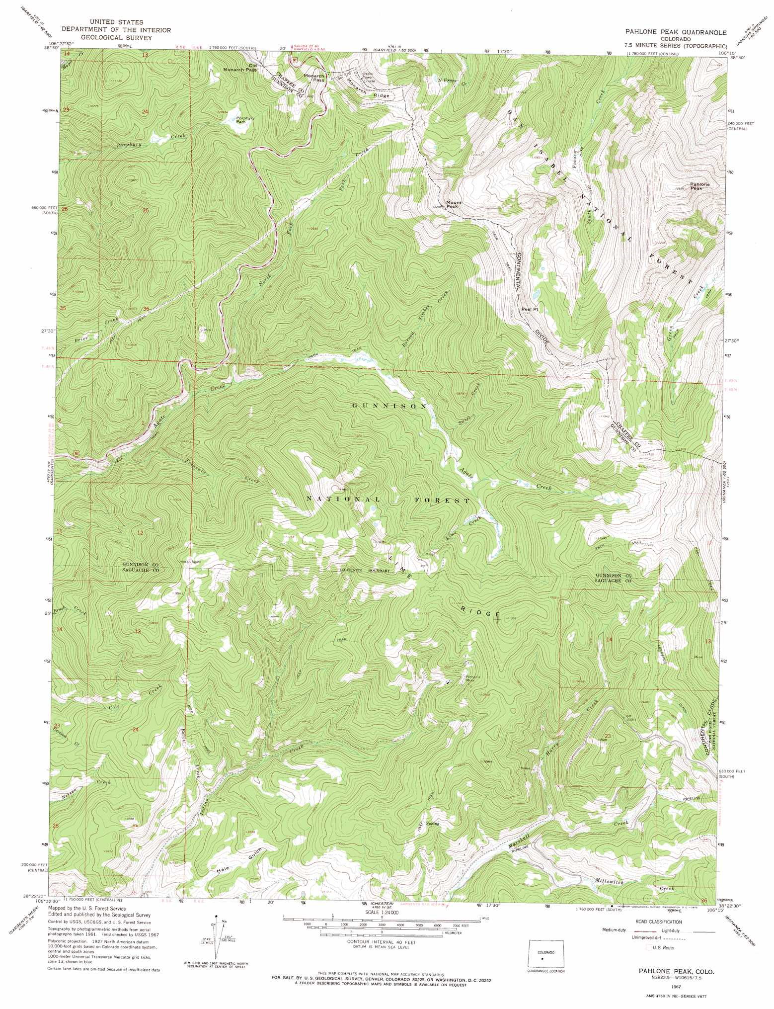
USGS Topo Quad 38106d3 - 1:24,000 scale
| Topo Map Name: | Pahlone Peak |
| USGS Topo Quad ID: | 38106d3 |
| Print Size: | ca. 21 1/4" wide x 27" high |
| Southeast Coordinates: | 38.375° N latitude / 106.25° W longitude |
| Map Center Coordinates: | 38.4375° N latitude / 106.3125° W longitude |
| U.S. State: | CO |
| Filename: | o38106d3.jpg |
| Download Map JPG Image: | Pahlone Peak topo map 1:24,000 scale |
| Map Type: | Topographic |
| Topo Series: | 7.5´ |
| Map Scale: | 1:24,000 |
| Source of Map Images: | United States Geological Survey (USGS) |
| Alternate Map Versions: |
Pahlone Peak CO 1967, updated 1969 Download PDF Buy paper map Pahlone Peak CO 1967, updated 1969 Download PDF Buy paper map Pahlone Peak CO 1967, updated 1970 Download PDF Buy paper map Pahlone Peak CO 1994, updated 1998 Download PDF Buy paper map Pahlone Peak CO 2011 Download PDF Buy paper map Pahlone Peak CO 2013 Download PDF Buy paper map Pahlone Peak CO 2016 Download PDF Buy paper map |
| FStopo: | US Forest Service topo Pahlone Peak is available: Download FStopo PDF Download FStopo TIF |
1:24,000 Topo Quads surrounding Pahlone Peak
Fairview Peak |
Cumberland Pass |
Saint Elmo |
Mount Antero |
Nathrop |
Pitkin |
Whitepine |
Garfield |
Maysville |
Salida West |
Doyleville |
Sargents |
Pahlone Peak |
Mount Ouray |
Poncha Pass |
West Baldy |
Sargents Mesa |
Chester |
Bonanza |
Whale Hill |
North Pass |
Trickle Mountain |
Lake Mountain Ne |
Klondike Mine |
Graveyard Gulch |
> Back to 38106a1 at 1:100,000 scale
> Back to 38106a1 at 1:250,000 scale
> Back to U.S. Topo Maps home
Pahlone Peak topo map: Gazetteer
Pahlone Peak: Canals
Larkspur Ditch elevation 3330m 10925′Pahlone Peak: Dams
Pitch Wastewater Treatment Reservoir Dam elevation 3011m 9878′Pahlone Peak: Flats
Porphyry Park elevation 3275m 10744′Pahlone Peak: Gaps
Monarch Pass elevation 3446m 11305′Old Monarch Pass elevation 3465m 11368′
Pahlone Peak: Mines
Apache Number Four Mine elevation 3009m 9872′Big Indian Group Mine elevation 2933m 9622′
D and J Mine elevation 3359m 11020′
Erie Number Thirty-three Mine elevation 3395m 11138′
Indian Creek Bog Iron Mine elevation 3227m 10587′
Jasper Mine elevation 3790m 12434′
Little Indian Number Six Mine elevation 3047m 9996′
Lookout Number Twenty-two Mine elevation 3218m 10557′
Marshall Pass Group Mine elevation 2908m 9540′
Pinnacle Mine elevation 3209m 10528′
Pitch Mine elevation 3145m 10318′
Taylor Mining Syndicate Mine elevation 3166m 10387′
Uncompahgre Number One Mine elevation 3218m 10557′
Pahlone Peak: Reservoirs
Mine Wastewater Treatment Reservoir elevation 3011m 9878′Pahlone Peak: Ridges
Lime Ridge elevation 3610m 11843′Pahlone Peak: Streams
Bulls Creek elevation 2759m 9051′Burned Timber Creek elevation 3033m 9950′
Harry Creek elevation 2924m 9593′
Hidden Creek elevation 3011m 9878′
Lime Creek elevation 3163m 10377′
Millswitch Creek elevation 2891m 9484′
North Fork Agate Creek elevation 2935m 9629′
Park Creek elevation 3174m 10413′
Treasure Creek elevation 2812m 9225′
Pahlone Peak: Summits
Mount Peck elevation 3720m 12204′Pahlone Peak elevation 3845m 12614′
Peel Point elevation 3701m 12142′
Pahlone Peak digital topo map on disk
Buy this Pahlone Peak topo map showing relief, roads, GPS coordinates and other geographical features, as a high-resolution digital map file on DVD: