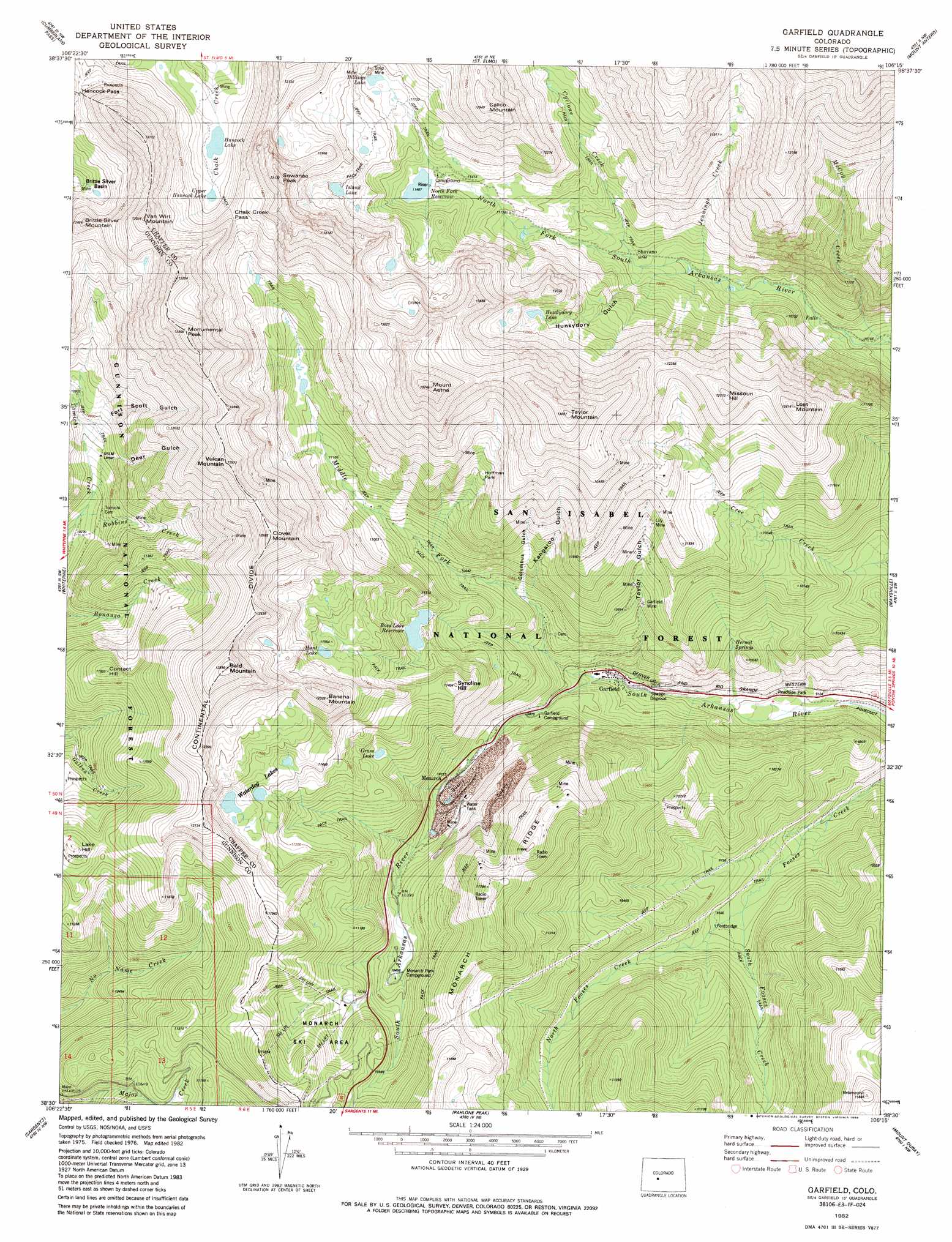
Garfield Topo Map Colorado
To zoom in, hover over the map of Garfield
USGS Topo Quad 38106e3 - 1:24,000 scale
| Topo Map Name: | Garfield |
| USGS Topo Quad ID: | 38106e3 |
| Print Size: | ca. 21 1/4" wide x 27" high |
| Southeast Coordinates: | 38.5° N latitude / 106.25° W longitude |
| Map Center Coordinates: | 38.5625° N latitude / 106.3125° W longitude |
| U.S. State: | CO |
| Filename: | o38106e3.jpg |
| Download Map JPG Image: | Garfield topo map 1:24,000 scale |
| Map Type: | Topographic |
| Topo Series: | 7.5´ |
| Map Scale: | 1:24,000 |
| Source of Map Images: | United States Geological Survey (USGS) |
| Alternate Map Versions: |
Garfield CO 1982, updated 1983 Download PDF Buy paper map Garfield CO 1982, updated 1986 Download PDF Buy paper map Garfield CO 1994, updated 1998 Download PDF Buy paper map Garfield CO 2011 Download PDF Buy paper map Garfield CO 2013 Download PDF Buy paper map Garfield CO 2016 Download PDF Buy paper map |
| FStopo: | US Forest Service topo Garfield is available: Download FStopo PDF Download FStopo TIF |
1:24,000 Topo Quads surrounding Garfield
Taylor Park Reservoir |
Tincup |
Mount Yale |
Buena Vista West |
Buena Vista East |
Fairview Peak |
Cumberland Pass |
Saint Elmo |
Mount Antero |
Nathrop |
Pitkin |
Whitepine |
Garfield |
Maysville |
Salida West |
Doyleville |
Sargents |
Pahlone Peak |
Mount Ouray |
Poncha Pass |
West Baldy |
Sargents Mesa |
Chester |
Bonanza |
Whale Hill |
> Back to 38106e1 at 1:100,000 scale
> Back to 38106a1 at 1:250,000 scale
> Back to U.S. Topo Maps home
Garfield topo map: Gazetteer
Garfield: Dams
Boss Lake Dam elevation 3356m 11010′North Fork Dam elevation 3482m 11423′
Garfield: Flats
Hoffman Park elevation 3581m 11748′Garfield: Gaps
Chalk Creek Pass elevation 3700m 12139′Hancock Pass elevation 3722m 12211′
Original Monarch Pass elevation 3515m 11532′
Garfield: Lakes
Billings Lake elevation 3582m 11751′Hancock Lake elevation 3555m 11663′
Hunkydory Lake elevation 3604m 11824′
Hunt Lake elevation 3498m 11476′
Island Lake elevation 3653m 11984′
Upper Hancock Lake elevation 3579m 11742′
Waterdog Lakes elevation 3473m 11394′
Garfield: Mines
Alaska Mine elevation 3127m 10259′Alpha and Beta Mine elevation 3523m 11558′
Anna Huffman Copper Mine elevation 3557m 11669′
April Fool Mine elevation 3401m 11158′
Ben Bolts Paymaster Mine elevation 3444m 11299′
Black Tiger Mine elevation 2899m 9511′
Bonnie Belle Mine elevation 3523m 11558′
Brighton Mine elevation 4053m 13297′
Burton Quarry elevation 3444m 11299′
Clinton Mine elevation 3462m 11358′
Columbus Mine elevation 3321m 10895′
Darling Mine elevation 3682m 12080′
Delaware Mine elevation 3444m 11299′
Desdemona Mine elevation 3645m 11958′
Eclipse Mine elevation 3197m 10488′
Elkington Mine elevation 3390m 11122′
Evening Star Mine elevation 3247m 10652′
Fairplay Mine elevation 3214m 10544′
Flora Belle Mine elevation 3551m 11650′
Fraction Mine elevation 3592m 11784′
French Quarry elevation 3444m 11299′
Garfield Mine elevation 3231m 10600′
Giant Eclipse Mine elevation 2861m 9386′
Golden Age Mine elevation 3626m 11896′
Grand Monarch Mine elevation 3444m 11299′
Great Monarch Mine elevation 3308m 10853′
Half Moon Mine elevation 3312m 10866′
Hawkeye Number One Mine elevation 3408m 11181′
Hawkeye Number Three Mine elevation 3364m 11036′
Hawkeye Number Two Mine elevation 3234m 10610′
Indianapolis Mine elevation 3706m 12158′
Irishwood Esther Mine elevation 3550m 11646′
Iron Duke Mine elevation 3825m 12549′
Jewell Tunnel Mine elevation 3470m 11384′
Josephine Number One Quarry elevation 3428m 11246′
Last Chance Mine elevation 3581m 11748′
Lilly Mine elevation 3387m 11112′
Lily Mine elevation 3381m 11092′
Little Charm Mine elevation 3403m 11164′
Little Wonder Mine elevation 3099m 10167′
Madonna Mine elevation 3514m 11528′
Major Mine elevation 3477m 11407′
Mason Mine elevation 3789m 12431′
Missouri Boy Mine elevation 3517m 11538′
Monarch Lime Quarry elevation 3269m 10725′
Monongahela Mine elevation 3444m 11299′
Moss Flower Mine elevation 3312m 10866′
Mountain Chief Mine elevation 3666m 12027′
New York Mine elevation 3647m 11965′
Ohio and Morningstar Mine elevation 3444m 11299′
Oshkosh Mine elevation 3094m 10150′
Page Mine elevation 3503m 11492′
Paymaster Mine elevation 3514m 11528′
Pilgrim Group Mine elevation 3550m 11646′
Pinyon Mine elevation 3584m 11758′
Rainbow-Eagle Bird Mine elevation 3584m 11758′
Shamrock Mine elevation 3314m 10872′
Silent Friend Mine elevation 3422m 11227′
Silver King Mine elevation 3312m 10866′
Song Bird Mine elevation 3668m 12034′
South Quartz Creek Mine elevation 3671m 12043′
Thirty-six-thirty Mine elevation 3875m 12713′
Wilson Mine elevation 3476m 11404′
Garfield: Populated Places
Garfield elevation 2909m 9543′Shavano (historical) elevation 3276m 10748′
Garfield: Reservoirs
Boss Lady Reservoir elevation 3285m 10777′Boss Lake Reservoir elevation 3312m 10866′
North Fork Reservoir elevation 3482m 11423′
Ross Lake Reservoir elevation 3356m 11010′
Garfield: Springs
Hermit Springs elevation 3033m 9950′Garfield: Streams
Cyclone Creek elevation 3269m 10725′Jennings Creek elevation 3205m 10515′
McCoy Creek elevation 3068m 10065′
Middle Fork South Arkansas River elevation 2936m 9632′
North Fooses Creek elevation 2910m 9547′
Robbins Creek elevation 3145m 10318′
South Fooses Creek elevation 2910m 9547′
Garfield: Summits
Bald Mountain elevation 3894m 12775′Banana Mountain elevation 3744m 12283′
Brittle Silver Mountain elevation 3789m 12431′
Calico Mountain elevation 3579m 11742′
Clover Mountain elevation 3835m 12582′
Contact Hill elevation 3530m 11581′
Lake Hill elevation 3527m 11571′
Lost Mountain elevation 3805m 12483′
Missouri Hill elevation 3846m 12618′
Monumental Peak elevation 4067m 13343′
Mount Aetna elevation 4160m 13648′
Sewanee Peak elevation 3936m 12913′
Syncline Hill elevation 3469m 11381′
Taylor Mountain elevation 4145m 13599′
Van Wirt Mountain elevation 3957m 12982′
Vulcan Mountain elevation 3936m 12913′
Garfield: Trails
Fooses Creek Trail elevation 3008m 9868′Garfield: Valleys
Columbus Gulch elevation 3171m 10403′Deer Gulch elevation 3208m 10524′
Fort Scott Gulch elevation 3219m 10561′
Hunkydory Gulch elevation 3273m 10738′
Kangaroo Gulch elevation 3146m 10321′
Taylor Gulch elevation 2981m 9780′
Garfield digital topo map on disk
Buy this Garfield topo map showing relief, roads, GPS coordinates and other geographical features, as a high-resolution digital map file on DVD: