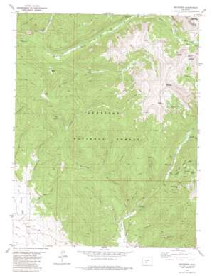
Whitepine Topo Map Colorado
To zoom in, hover over the map of Whitepine
USGS Topo Quad 38106e4 - 1:24,000 scale
| Topo Map Name: | Whitepine |
| USGS Topo Quad ID: | 38106e4 |
| Print Size: | ca. 21 1/4" wide x 27" high |
| Southeast Coordinates: | 38.5° N latitude / 106.375° W longitude |
| Map Center Coordinates: | 38.5625° N latitude / 106.4375° W longitude |
| U.S. State: | CO |
| Filename: | o38106e4.jpg |
| Download Map JPG Image: | Whitepine topo map 1:24,000 scale |
| Map Type: | Topographic |
| Topo Series: | 7.5´ |
| Map Scale: | 1:24,000 |
| Source of Map Images: | United States Geological Survey (USGS) |
| Alternate Map Versions: |
Whitepine CO 1982, updated 1983 Download PDF Buy paper map Whitepine CO 1982, updated 1983 Download PDF Buy paper map Whitepine CO 2001, updated 2004 Download PDF Buy paper map Whitepine CO 2011 Download PDF Buy paper map Whitepine CO 2013 Download PDF Buy paper map Whitepine CO 2016 Download PDF Buy paper map |
| FStopo: | US Forest Service topo Whitepine is available: Download FStopo PDF Download FStopo TIF |
1:24,000 Topo Quads surrounding Whitepine
> Back to 38106e1 at 1:100,000 scale
> Back to 38106a1 at 1:250,000 scale
> Back to U.S. Topo Maps home
Whitepine topo map: Gazetteer
Whitepine: Basins
Brittle Silver Basin elevation 3469m 11381′Whitepine: Flats
Depler Park elevation 3086m 10124′Whitepine: Gaps
Tomichi Pass elevation 3646m 11961′Whitepine: Mines
Akron Mine elevation 2962m 9717′Akron Mine elevation 3060m 10039′
Big Red Twenty-two Mine elevation 3191m 10469′
Brittle Basin Mine elevation 3267m 10718′
David H Shaft Mine elevation 3162m 10374′
Ensign Tunnel Mine elevation 3162m 10374′
Erie Mine elevation 3294m 10807′
Graphite Basin Mine elevation 3414m 11200′
Morning Star Mine elevation 3203m 10508′
Morning Star Mine elevation 3060m 10039′
Nest Egg Mine elevation 2923m 9589′
North Star Mine elevation 3081m 10108′
Parole Mine elevation 3207m 10521′
Princeton and Blackhawk Mine elevation 3389m 11118′
Tomichi Mine elevation 2999m 9839′
Victor Mine elevation 3060m 10039′
Victor Mine elevation 3042m 9980′
White Pine Mine elevation 2923m 9589′
Whitepine: Populated Places
Whitepine elevation 2960m 9711′Whitepine: Ridges
Porcupine Ridge elevation 3213m 10541′Whitepine: Streams
Bonanza Creek elevation 3047m 9996′Bonnie Creek elevation 3089m 10134′
Buckhorn Creek elevation 3111m 10206′
Buffalo Fork elevation 3080m 10104′
Canyon Creek elevation 2784m 9133′
East Canyon Creek elevation 2950m 9678′
Egg Rock Creek elevation 2817m 9242′
Galena Creek elevation 2937m 9635′
Graveyard Creek elevation 2873m 9425′
Horseshoe Creek elevation 2900m 9514′
Middle Quartz Creek elevation 2856m 9370′
North Quartz Creek elevation 2856m 9370′
South Quartz Creek elevation 2956m 9698′
Spring Creek elevation 2906m 9534′
Stridiron Gulch elevation 2744m 9002′
Whitepine: Summits
Central Mountain elevation 3762m 12342′Granite Mountain elevation 3779m 12398′
Little Baldy elevation 3458m 11345′
Mount Chapman elevation 3852m 12637′
Paywell Mountain elevation 3736m 12257′
Stella Mountain elevation 3819m 12529′
West Point Hill elevation 3246m 10649′
Whitepine: Trails
Coyote Park Trail elevation 2903m 9524′Pitkin Stock Driveway elevation 3191m 10469′
Whitepine: Valleys
Deadman Gulch elevation 2744m 9002′Eldorado Gulch elevation 2741m 8992′
Fitzpatrick Gulch elevation 3129m 10265′
Hicks Gulch elevation 2757m 9045′
Snowblind Gulch elevation 2755m 9038′
Whitepine digital topo map on disk
Buy this Whitepine topo map showing relief, roads, GPS coordinates and other geographical features, as a high-resolution digital map file on DVD:


