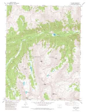
Saint Elmo Topo Map Colorado
To zoom in, hover over the map of Saint Elmo
USGS Topo Quad 38106f3 - 1:24,000 scale
| Topo Map Name: | Saint Elmo |
| USGS Topo Quad ID: | 38106f3 |
| Print Size: | ca. 21 1/4" wide x 27" high |
| Southeast Coordinates: | 38.625° N latitude / 106.25° W longitude |
| Map Center Coordinates: | 38.6875° N latitude / 106.3125° W longitude |
| U.S. State: | CO |
| Filename: | o38106f3.jpg |
| Download Map JPG Image: | Saint Elmo topo map 1:24,000 scale |
| Map Type: | Topographic |
| Topo Series: | 7.5´ |
| Map Scale: | 1:24,000 |
| Source of Map Images: | United States Geological Survey (USGS) |
| Alternate Map Versions: |
Saint Elmo CO 1982, updated 1983 Download PDF Buy paper map Saint Elmo CO 1994, updated 1998 Download PDF Buy paper map Saint Elmo CO 2011 Download PDF Buy paper map Saint Elmo CO 2013 Download PDF Buy paper map Saint Elmo CO 2016 Download PDF Buy paper map |
| FStopo: | US Forest Service topo Saint Elmo is available: Download FStopo PDF Download FStopo TIF |
1:24,000 Topo Quads surrounding Saint Elmo
> Back to 38106e1 at 1:100,000 scale
> Back to 38106a1 at 1:250,000 scale
> Back to U.S. Topo Maps home
Saint Elmo topo map: Gazetteer
Saint Elmo: Lakes
Baldwin Lake elevation 3678m 12066′Grizzly Lake elevation 3410m 11187′
Pomeroy Lake elevation 3668m 12034′
Upper Pomeroy Lake elevation 3739m 12267′
Saint Elmo: Mines
Alpine Number One Quarry elevation 3055m 10022′Black Hawk Mine elevation 3055m 10022′
Elmer McMurray Mine elevation 2953m 9688′
Fairview Mine elevation 3577m 11735′
Forward Gold Mining Company Mine elevation 3055m 10022′
Garfield Quarry elevation 4127m 13540′
Iron Chest Mine elevation 3606m 11830′
Lehigh Mine elevation 2806m 9206′
Maple Leaf Mine elevation 3055m 10022′
Mary Murphy Mine elevation 3711m 12175′
Mary Murphy Mine elevation 3836m 12585′
Matilda Mine elevation 3055m 10022′
Ole Bull Mine elevation 3055m 10022′
Pride of the West Mine elevation 3714m 12185′
Rarus Warrior Mine elevation 3655m 11991′
Rolla Mine elevation 3655m 11991′
Stonewall Shaft Mine elevation 3450m 11318′
Tilden Mine elevation 3583m 11755′
Uncle Sam Mine elevation 3998m 13116′
Saint Elmo: Populated Places
Alpine (historical) elevation 2825m 9268′Hancock (historical) elevation 3380m 11089′
Iron City (historical) elevation 3018m 9901′
Romley (historical) elevation 3145m 10318′
Saint Elmo (historical) elevation 3050m 10006′
Stonewall (historical) elevation 3433m 11263′
Saint Elmo: Reservoirs
Alpine Lake elevation 2853m 9360′Saint Elmo: Ridges
Mountain Morning Ridge elevation 4220m 13845′Saint Elmo: Streams
Baldwin Creek elevation 2801m 9189′North Fork Chalk Creek elevation 3049m 10003′
Saint Elmo: Summits
Boulder Mountain elevation 4111m 13487′Carbonate Mountain elevation 4070m 13353′
Chrysolite Mountain elevation 3843m 12608′
Cronin Peak elevation 4207m 13802′
Cyclone Mountain elevation 4132m 13556′
Grizzly Mountain elevation 4171m 13684′
Mount Mamma elevation 4124m 13530′
Pomeroy Mountain elevation 3931m 12896′
Tabeguache Peak elevation 4260m 13976′
Saint Elmo: Valleys
Baldwin Gulch elevation 3324m 10905′Coal Camp Canyon elevation 2955m 9694′
Deer Canyon elevation 2907m 9537′
Grizzly Gulch elevation 3038m 9967′
Grouse Canyon elevation 3738m 12263′
Pomeroy Gulch elevation 3241m 10633′
Poplar Gulch elevation 3002m 9849′
Sheep Canyon elevation 2887m 9471′
Weldon Gulch elevation 2821m 9255′
Saint Elmo digital topo map on disk
Buy this Saint Elmo topo map showing relief, roads, GPS coordinates and other geographical features, as a high-resolution digital map file on DVD:


