Marmot Peak Topo Map Colorado
To zoom in, hover over the map of Marmot Peak
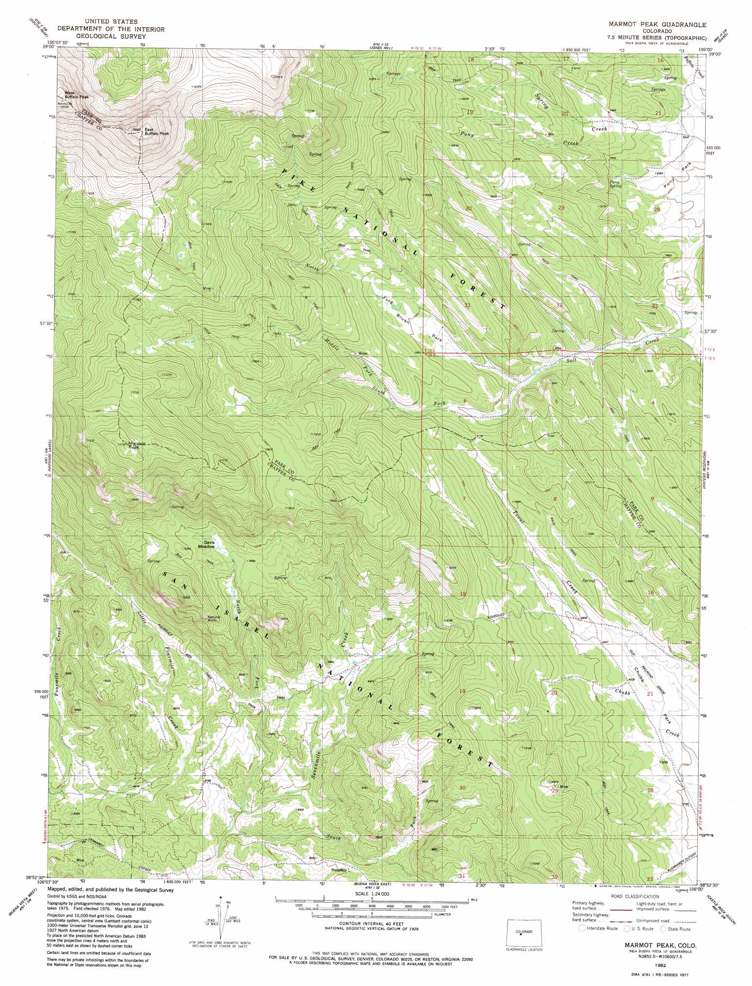
USGS Topo Quad 38106h1 - 1:24,000 scale
| Topo Map Name: | Marmot Peak |
| USGS Topo Quad ID: | 38106h1 |
| Print Size: | ca. 21 1/4" wide x 27" high |
| Southeast Coordinates: | 38.875° N latitude / 106° W longitude |
| Map Center Coordinates: | 38.9375° N latitude / 106.0625° W longitude |
| U.S. State: | CO |
| Filename: | o38106h1.jpg |
| Download Map JPG Image: | Marmot Peak topo map 1:24,000 scale |
| Map Type: | Topographic |
| Topo Series: | 7.5´ |
| Map Scale: | 1:24,000 |
| Source of Map Images: | United States Geological Survey (USGS) |
| Alternate Map Versions: |
Marmot Peak CO 1982, updated 1983 Download PDF Buy paper map Marmot Peak CO 1982, updated 1983 Download PDF Buy paper map Marmot Peak CO 1994, updated 1998 Download PDF Buy paper map Marmot Peak CO 2011 Download PDF Buy paper map Marmot Peak CO 2013 Download PDF Buy paper map Marmot Peak CO 2016 Download PDF Buy paper map |
| FStopo: | US Forest Service topo Marmot Peak is available: Download FStopo PDF Download FStopo TIF |
1:24,000 Topo Quads surrounding Marmot Peak
Leadville South |
Mount Sherman |
Fairplay West |
Fairplay East |
Elkhorn |
Granite |
South Peak |
Jones Hill |
Garo |
Hartsel |
Mount Harvard |
Harvard Lakes |
Marmot Peak |
Antero Reservoir |
Antero Reservoir Ne |
Mount Yale |
Buena Vista West |
Buena Vista East |
Castle Rock Gulch |
Agate Mountain |
Saint Elmo |
Mount Antero |
Nathrop |
Cameron Mountain |
Gribbles Park |
> Back to 38106e1 at 1:100,000 scale
> Back to 38106a1 at 1:250,000 scale
> Back to U.S. Topo Maps home
Marmot Peak topo map: Gazetteer
Marmot Peak: Arches
Aspen Arch elevation 3027m 9931′Marmot Peak: Flats
Brush Park elevation 3010m 9875′Davis Meadow elevation 3018m 9901′
Pony Park elevation 2832m 9291′
Marmot Peak: Springs
Pony Spring elevation 2859m 9379′Marmot Peak: Streams
Little Fourmile Creek elevation 2550m 8366′Middle Fork Salt Creek elevation 2976m 9763′
North Fork Salt Creek elevation 2948m 9671′
North Fork Sevenmile Creek elevation 2625m 8612′
South Fork Salt Creek elevation 2976m 9763′
South Fork Sevenmile Creek elevation 2616m 8582′
Marmot Peak: Summits
East Buffalo Peak elevation 4057m 13310′Marmot Peak elevation 3573m 11722′
Marmot Peak digital topo map on disk
Buy this Marmot Peak topo map showing relief, roads, GPS coordinates and other geographical features, as a high-resolution digital map file on DVD: