Winfield Topo Map Colorado
To zoom in, hover over the map of Winfield
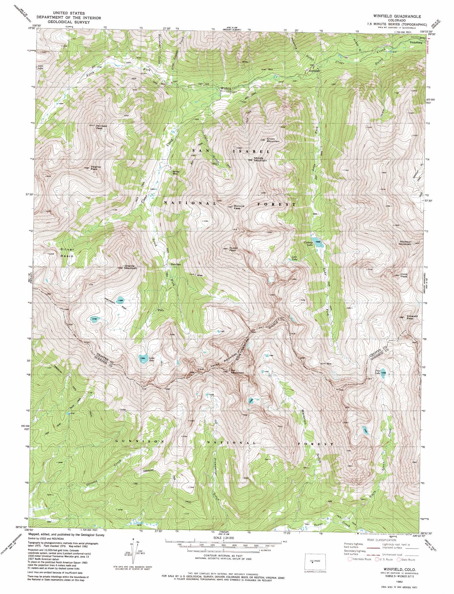
USGS Topo Quad 38106h4 - 1:24,000 scale
| Topo Map Name: | Winfield |
| USGS Topo Quad ID: | 38106h4 |
| Print Size: | ca. 21 1/4" wide x 27" high |
| Southeast Coordinates: | 38.875° N latitude / 106.375° W longitude |
| Map Center Coordinates: | 38.9375° N latitude / 106.4375° W longitude |
| U.S. State: | CO |
| Filename: | o38106h4.jpg |
| Download Map JPG Image: | Winfield topo map 1:24,000 scale |
| Map Type: | Topographic |
| Topo Series: | 7.5´ |
| Map Scale: | 1:24,000 |
| Source of Map Images: | United States Geological Survey (USGS) |
| Alternate Map Versions: |
Winfield CO 1982, updated 1983 Download PDF Buy paper map Winfield CO 1982, updated 1985 Download PDF Buy paper map Winfield CO 1982, updated 1985 Download PDF Buy paper map Winfield CO 1994, updated 2001 Download PDF Buy paper map Winfield CO 2011 Download PDF Buy paper map Winfield CO 2013 Download PDF Buy paper map Winfield CO 2016 Download PDF Buy paper map |
| FStopo: | US Forest Service topo Winfield is available: Download FStopo PDF Download FStopo TIF |
1:24,000 Topo Quads surrounding Winfield
Thimble Rock |
Mount Champion |
Mount Massive |
Leadville South |
Mount Sherman |
New York Peak |
Independence Pass |
Mount Elbert |
Granite |
South Peak |
Italian Creek |
Pieplant |
Winfield |
Mount Harvard |
Harvard Lakes |
Matchless Mountain |
Taylor Park Reservoir |
Tincup |
Mount Yale |
Buena Vista West |
Crystal Creek |
Fairview Peak |
Cumberland Pass |
Saint Elmo |
Mount Antero |
> Back to 38106e1 at 1:100,000 scale
> Back to 38106a1 at 1:250,000 scale
> Back to U.S. Topo Maps home
Winfield topo map: Gazetteer
Winfield: Basins
Missouri Basin elevation 3779m 12398′Silver Basin elevation 3557m 11669′
Winfield: Flats
Harrison Flat elevation 3648m 11968′Winfield: Lakes
Clohesy Lake elevation 3345m 10974′Lake Ann elevation 3600m 11811′
Lois Lake elevation 3601m 11814′
Pear Lake elevation 3687m 12096′
Winfield: Mines
Banker Mine elevation 3249m 10659′Fortune Mine elevation 3483m 11427′
Last Dollar Mine elevation 3413m 11197′
Little Guy Mine elevation 3116m 10223′
Middle Mountain Mine elevation 3425m 11236′
Mike Rabbit Mine elevation 3831m 12568′
Swiss Boy Dump Mine elevation 3209m 10528′
Tasmania Mine elevation 3566m 11699′
Winfield: Populated Places
Rockdale elevation 3045m 9990′Vicksburg elevation 2948m 9671′
Winfield elevation 3122m 10242′
Winfield: Streams
Blackbear Creek elevation 3232m 10603′Grey Copper Creek elevation 3187m 10456′
Lake Fork elevation 3033m 9950′
North Fork Clear Creek elevation 3118m 10229′
North Texas Creek elevation 3085m 10121′
South Fork Clear Creek elevation 3118m 10229′
Winfield: Summits
Browns Peak elevation 3747m 12293′Cross Mountain elevation 3919m 12857′
Emerald Peak elevation 4232m 13884′
Granite Mountain elevation 3901m 12798′
Huron Peak elevation 4252m 13950′
Ice Mountain elevation 4220m 13845′
Iowa Peak elevation 4209m 13809′
Middle Mountain elevation 3968m 13018′
Missouri Mountain elevation 4265m 13992′
The Three Apostles elevation 4201m 13782′
Virginia Peak elevation 3979m 13054′
Winfield Peak elevation 3359m 11020′
Winfield: Valleys
Hewitts Gulch elevation 3027m 9931′Iwoa Gulch elevation 2961m 9714′
Lulu Gulch elevation 3128m 10262′
Sheep Gulch elevation 3047m 9996′
Waterloo Gulch elevation 3063m 10049′
Winfield digital topo map on disk
Buy this Winfield topo map showing relief, roads, GPS coordinates and other geographical features, as a high-resolution digital map file on DVD: