Italian Creek Topo Map Colorado
To zoom in, hover over the map of Italian Creek
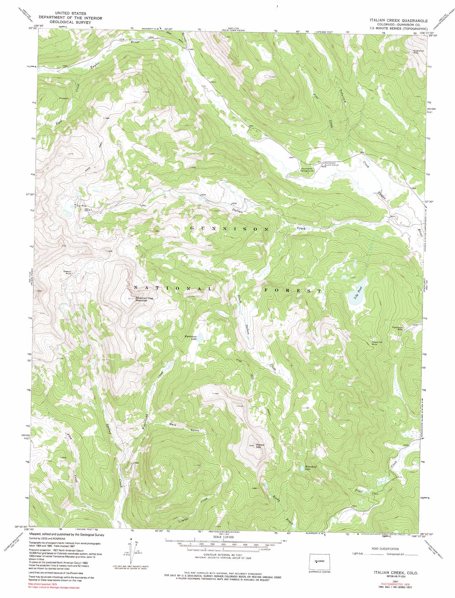
USGS Topo Quad 38106h6 - 1:24,000 scale
| Topo Map Name: | Italian Creek |
| USGS Topo Quad ID: | 38106h6 |
| Print Size: | ca. 21 1/4" wide x 27" high |
| Southeast Coordinates: | 38.875° N latitude / 106.625° W longitude |
| Map Center Coordinates: | 38.9375° N latitude / 106.6875° W longitude |
| U.S. State: | CO |
| Filename: | o38106h6.jpg |
| Download Map JPG Image: | Italian Creek topo map 1:24,000 scale |
| Map Type: | Topographic |
| Topo Series: | 7.5´ |
| Map Scale: | 1:24,000 |
| Source of Map Images: | United States Geological Survey (USGS) |
| Alternate Map Versions: |
Italian Creek CO 1967, updated 1971 Download PDF Buy paper map Italian Creek CO 1967, updated 1971 Download PDF Buy paper map Italian Creek CO 1967, updated 1975 Download PDF Buy paper map Italian Creek CO 1967, updated 1975 Download PDF Buy paper map Italian Creek CO 1967, updated 1991 Download PDF Buy paper map Italian Creek CO 1967, updated 1991 Download PDF Buy paper map Italian Creek CO 2001, updated 2004 Download PDF Buy paper map Italian Creek CO 2011 Download PDF Buy paper map Italian Creek CO 2013 Download PDF Buy paper map Italian Creek CO 2016 Download PDF Buy paper map |
| FStopo: | US Forest Service topo Italian Creek is available: Download FStopo PDF Download FStopo TIF |
1:24,000 Topo Quads surrounding Italian Creek
Highland Peak |
Aspen |
Thimble Rock |
Mount Champion |
Mount Massive |
Maroon Bells |
Hayden Peak |
New York Peak |
Independence Pass |
Mount Elbert |
Gothic |
Pearl Pass |
Italian Creek |
Pieplant |
Winfield |
Crested Butte |
Cement Mountain |
Matchless Mountain |
Taylor Park Reservoir |
Tincup |
Flat Top |
Almont |
Crystal Creek |
Fairview Peak |
Cumberland Pass |
> Back to 38106e1 at 1:100,000 scale
> Back to 38106a1 at 1:250,000 scale
> Back to U.S. Topo Maps home
Italian Creek topo map: Gazetteer
Italian Creek: Lakes
Horsethief Lake elevation 3423m 11230′Lily Pond elevation 3203m 10508′
Mysterious Lake elevation 3436m 11272′
Italian Creek: Mines
Bull Domingo Shaft Mine elevation 3550m 11646′Colorado Mine elevation 3567m 11702′
Comet Group Mine elevation 3595m 11794′
Enterprise Mine elevation 3575m 11729′
Forest Hill Mine elevation 3274m 10741′
Independent Shaft Mine elevation 3552m 11653′
Last Hope Mine elevation 3492m 11456′
Paymaster Mine elevation 3079m 10101′
Star Mine elevation 3552m 11653′
Stewart Mine elevation 3619m 11873′
Thunderbird Mine elevation 3395m 11138′
Tunnel Proposition Mine elevation 3812m 12506′
Italian Creek: Streams
Bowman Creek elevation 3069m 10068′Eyre Creek elevation 3200m 10498′
Flag Creek elevation 3053m 10016′
Italian Creek elevation 2979m 9773′
Mysterious Creek elevation 3125m 10252′
Pine Creek elevation 3000m 9842′
South Italian Creek elevation 3069m 10068′
Tellurium Creek elevation 2987m 9799′
Italian Creek: Summits
American Flag Mountain elevation 3875m 12713′Forest Hill elevation 3795m 12450′
Italian Creek: Trails
Star Trail elevation 3450m 11318′Italian Creek: Valleys
Dark Gulch elevation 3219m 10561′Italian Creek digital topo map on disk
Buy this Italian Creek topo map showing relief, roads, GPS coordinates and other geographical features, as a high-resolution digital map file on DVD: