Uncompahgre Peak Topo Map Colorado
To zoom in, hover over the map of Uncompahgre Peak
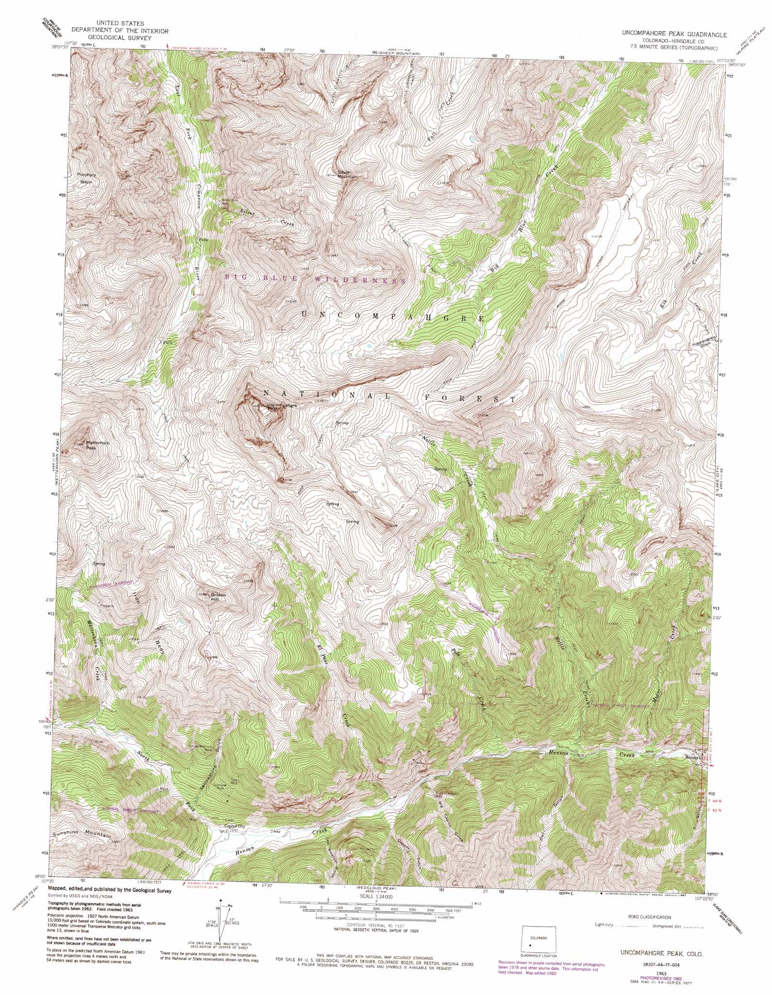
USGS Topo Quad 38107a4 - 1:24,000 scale
| Topo Map Name: | Uncompahgre Peak |
| USGS Topo Quad ID: | 38107a4 |
| Print Size: | ca. 21 1/4" wide x 27" high |
| Southeast Coordinates: | 38° N latitude / 107.375° W longitude |
| Map Center Coordinates: | 38.0625° N latitude / 107.4375° W longitude |
| U.S. State: | CO |
| Filename: | o38107a4.jpg |
| Download Map JPG Image: | Uncompahgre Peak topo map 1:24,000 scale |
| Map Type: | Topographic |
| Topo Series: | 7.5´ |
| Map Scale: | 1:24,000 |
| Source of Map Images: | United States Geological Survey (USGS) |
| Alternate Map Versions: |
Uncompahgre Peak CO 1963, updated 1966 Download PDF Buy paper map Uncompahgre Peak CO 1963, updated 1970 Download PDF Buy paper map Uncompahgre Peak CO 1963, updated 1984 Download PDF Buy paper map Uncompahgre Peak CO 1963, updated 1987 Download PDF Buy paper map Uncompahgre Peak CO 1963, updated 1987 Download PDF Buy paper map Uncompahgre Peak CO 1964, updated 1966 Download PDF Buy paper map Uncompahgre Peak CO 2011 Download PDF Buy paper map Uncompahgre Peak CO 2013 Download PDF Buy paper map Uncompahgre Peak CO 2016 Download PDF Buy paper map |
| FStopo: | US Forest Service topo Uncompahgre Peak is available: Download FStopo PDF Download FStopo TIF |
1:24,000 Topo Quads surrounding Uncompahgre Peak
Buckhorn Lakes |
Washboard Rock |
Lost Lake |
Poison Draw |
Gateview |
Dallas |
Courthouse Mountain |
Sheep Mountain |
Alpine Plateau |
Powderhorn Lakes |
Ouray |
Wetterhorn Peak |
Uncompahgre Peak |
Lake City |
Cannibal Plateau |
Ironton |
Handies Peak |
Redcloud Peak |
Lake San Cristobal |
Slumgullion Pass |
Silverton |
Howardsville |
Pole Creek Mountain |
Finger Mesa |
Hermit Lakes |
> Back to 38107a1 at 1:100,000 scale
> Back to 38106a1 at 1:250,000 scale
> Back to U.S. Topo Maps home
Uncompahgre Peak topo map: Gazetteer
Uncompahgre Peak: Cliffs
Iron Beds elevation 3684m 12086′Uncompahgre Peak: Mines
Ajax Number Two Mine elevation 2963m 9721′Bess Mine elevation 2963m 9721′
Beth Number One Mine elevation 3893m 12772′
Capitol City Mine elevation 2960m 9711′
Czar Mine elevation 3283m 10770′
Czarina Mine elevation 3212m 10538′
Excelsior Mine elevation 3155m 10351′
Gallic-Vulcan Mine elevation 3432m 11259′
Pride of America Mine elevation 3031m 9944′
Resorgimento Mine elevation 3031m 9944′
Saint Louis Mine elevation 3004m 9855′
Silver Jack Mine elevation 3383m 11099′
Ute and Ulay Group Mine elevation 2775m 9104′
Vermont Mine elevation 3000m 9842′
Woodstock Mine elevation 3392m 11128′
Yellow Medicine Mine elevation 3358m 11017′
Young America Mine elevation 3000m 9842′
Uncompahgre Peak: Populated Places
Capitol City (historical) elevation 2960m 9711′Henson elevation 2815m 9235′
Uncompahgre Peak: Streams
El Paso Creek elevation 2900m 9514′Matterhorn Creek elevation 3178m 10426′
Modoc Creek elevation 2801m 9189′
Nellie Creek elevation 2830m 9284′
North Fork Henson Creek elevation 2945m 9662′
Pole Creek elevation 2862m 9389′
Silver Creek elevation 3309m 10856′
Ute Creek elevation 2777m 9110′
Uncompahgre Peak: Summits
Broken Hill elevation 4028m 13215′Matterhorn Peak elevation 4119m 13513′
Silver Mountain elevation 4176m 13700′
Uncompahgre Peak elevation 4359m 14301′
Uncompahgre Peak: Trails
Big Blue Trail elevation 3739m 12267′Uncompahgre Peak: Valleys
Big Casino Gulch elevation 2906m 9534′Copper Gulch elevation 2918m 9573′
Lee Smelter Gulch elevation 2928m 9606′
Owl Gulch elevation 2837m 9307′
Yellowstone Gulch elevation 3049m 10003′
Uncompahgre Peak digital topo map on disk
Buy this Uncompahgre Peak topo map showing relief, roads, GPS coordinates and other geographical features, as a high-resolution digital map file on DVD: