Buckhorn Lakes Topo Map Colorado
To zoom in, hover over the map of Buckhorn Lakes
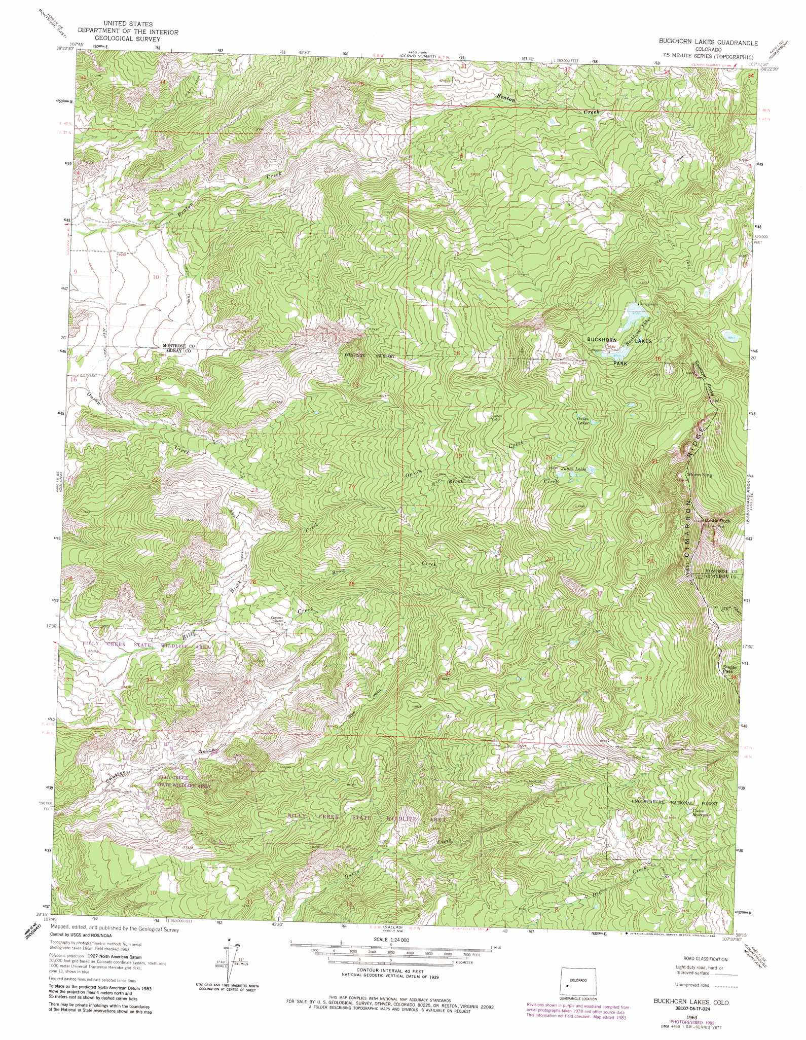
USGS Topo Quad 38107c6 - 1:24,000 scale
| Topo Map Name: | Buckhorn Lakes |
| USGS Topo Quad ID: | 38107c6 |
| Print Size: | ca. 21 1/4" wide x 27" high |
| Southeast Coordinates: | 38.25° N latitude / 107.625° W longitude |
| Map Center Coordinates: | 38.3125° N latitude / 107.6875° W longitude |
| U.S. State: | CO |
| Filename: | o38107c6.jpg |
| Download Map JPG Image: | Buckhorn Lakes topo map 1:24,000 scale |
| Map Type: | Topographic |
| Topo Series: | 7.5´ |
| Map Scale: | 1:24,000 |
| Source of Map Images: | United States Geological Survey (USGS) |
| Alternate Map Versions: |
Buckhorn Lakes CO 1963, updated 1966 Download PDF Buy paper map Buckhorn Lakes CO 1963, updated 1966 Download PDF Buy paper map Buckhorn Lakes CO 1963, updated 1984 Download PDF Buy paper map Buckhorn Lakes CO 2011 Download PDF Buy paper map Buckhorn Lakes CO 2013 Download PDF Buy paper map Buckhorn Lakes CO 2016 Download PDF Buy paper map |
| FStopo: | US Forest Service topo Buckhorn Lakes is available: Download FStopo PDF Download FStopo TIF |
1:24,000 Topo Quads surrounding Buckhorn Lakes
Olathe |
Red Rock Canyon |
Grizzly Ridge |
Cathedral Peak |
X Lazy F Ranch |
Montrose West |
Montrose East |
Cerro Summit |
Cimarron |
Curecanti Needle |
Government Springs |
Colona |
Buckhorn Lakes |
Washboard Rock |
Lost Lake |
Horsefly Peak |
Ridgway |
Dallas |
Courthouse Mountain |
Sheep Mountain |
Sams |
Mount Sneffels |
Ouray |
Wetterhorn Peak |
Uncompahgre Peak |
> Back to 38107a1 at 1:100,000 scale
> Back to 38106a1 at 1:250,000 scale
> Back to U.S. Topo Maps home
Buckhorn Lakes topo map: Gazetteer
Buckhorn Lakes: Dams
Buckhorn Lake Number 1 Dam elevation 2914m 9560′Buckhorn Lake Number 2 Dam elevation 2976m 9763′
Chaffe Gulch Dentention Number 6 Dam elevation 2138m 7014′
Buckhorn Lakes: Gaps
Slagle Pass elevation 3359m 11020′Buckhorn Lakes: Lakes
Buckhorn Lakes elevation 2964m 9724′Jutten Lakes elevation 2942m 9652′
Onion Lakes elevation 2937m 9635′
Buckhorn Lakes: Mines
Tyler Mine elevation 2985m 9793′Buckhorn Lakes: Parks
Billy Creek State Wildlife Area elevation 2393m 7851′Buckhorn Lakes Park elevation 2976m 9763′
Buckhorn Lakes: Pillars
Castle Rock elevation 3496m 11469′Sawtooth Rocks elevation 3224m 10577′
Buckhorn Lakes: Reservoirs
Buckhorn Lake Number 1 elevation 2914m 9560′Buckhorn Lake Number 2 elevation 2976m 9763′
Chaffe Gulch Dentention Number 6 Reservoir elevation 2138m 7014′
Coons Reservoir elevation 3026m 9927′
Buckhorn Lakes: Streams
Brook Creek elevation 2115m 6938′Brow Creek elevation 2216m 7270′
Buckhorn Lakes: Summits
Storm King elevation 3456m 11338′Buckhorn Lakes digital topo map on disk
Buy this Buckhorn Lakes topo map showing relief, roads, GPS coordinates and other geographical features, as a high-resolution digital map file on DVD: