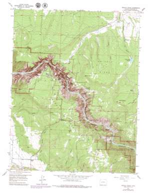
Grizzly Ridge Topo Map Colorado
To zoom in, hover over the map of Grizzly Ridge
USGS Topo Quad 38107e6 - 1:24,000 scale
| Topo Map Name: | Grizzly Ridge |
| USGS Topo Quad ID: | 38107e6 |
| Print Size: | ca. 21 1/4" wide x 27" high |
| Southeast Coordinates: | 38.5° N latitude / 107.625° W longitude |
| Map Center Coordinates: | 38.5625° N latitude / 107.6875° W longitude |
| U.S. State: | CO |
| Filename: | o38107e6.jpg |
| Download Map JPG Image: | Grizzly Ridge topo map 1:24,000 scale |
| Map Type: | Topographic |
| Topo Series: | 7.5´ |
| Map Scale: | 1:24,000 |
| Source of Map Images: | United States Geological Survey (USGS) |
| Alternate Map Versions: |
Grizzly Ridge CO 1957, updated 1959 Download PDF Buy paper map Grizzly Ridge CO 1957, updated 1959 Download PDF Buy paper map Grizzly Ridge CO 1957, updated 1965 Download PDF Buy paper map Grizzly Ridge CO 1957, updated 1965 Download PDF Buy paper map Grizzly Ridge CO 1957, updated 1979 Download PDF Buy paper map Grizzly Ridge CO 2010 Download PDF Buy paper map Grizzly Ridge CO 2013 Download PDF Buy paper map Grizzly Ridge CO 2016 Download PDF Buy paper map |
1:24,000 Topo Quads surrounding Grizzly Ridge
> Back to 38107e1 at 1:100,000 scale
> Back to 38106a1 at 1:250,000 scale
> Back to U.S. Topo Maps home
Grizzly Ridge topo map: Gazetteer
Grizzly Ridge: Canals
East Lateral elevation 2150m 7053′West Lateral elevation 2154m 7066′
Grizzly Ridge: Cliffs
Balanced Rock View elevation 2363m 7752′Big Island View elevation 2364m 7755′
Cedar Point elevation 2396m 7860′
Chasm View elevation 2337m 7667′
Chasm View elevation 2373m 7785′
Cross Fissures View elevation 2415m 7923′
Devils Lookout elevation 2399m 7870′
Devils Lookout elevation 2370m 7775′
Dragon Point elevation 2419m 7936′
Dragon Point elevation 2279m 7477′
Gunnison Point elevation 2463m 8080′
High Point elevation 2524m 8280′
Island Peaks View elevation 2420m 7939′
Kneeling Camel View elevation 2444m 8018′
Narrows View elevation 2371m 7778′
Painted Wall elevation 1924m 6312′
Painted Wall View elevation 2239m 7345′
Rock Point elevation 2454m 8051′
Rock Point elevation 2412m 7913′
Serpent Point elevation 2416m 7926′
Spruce Tree Point elevation 2446m 8024′
Sunset View elevation 2409m 7903′
Sunset View elevation 2449m 8034′
Tomichi Point elevation 2518m 8261′
Grizzly Ridge: Dams
Poison Spring Dam elevation 2490m 8169′Grizzly Ridge: Flats
Bostwick Park elevation 2154m 7066′Grizzly Ridge: Gaps
The Narrows elevation 1899m 6230′Grizzly Ridge: Parks
Black Canyon of the Gunnison National Monument elevation 2045m 6709′Grizzly Ridge: Pillars
Kneeling Camel elevation 2244m 7362′Pulpit Rock elevation 2460m 8070′
Grizzly Ridge: Reservoirs
Poison Spring Reservoir elevation 2490m 8169′Grizzly Ridge: Springs
Lions Spring elevation 2396m 7860′Poison Spring elevation 2616m 8582′
Grizzly Ridge: Summits
Big Island elevation 2380m 7808′Coffee Pot Hill elevation 2683m 8802′
Fruitland Mesa elevation 2538m 8326′
Green Mountain elevation 2614m 8576′
Grizzly Ridge elevation 2631m 8631′
High Point elevation 2527m 8290′
Island Peaks elevation 2195m 7201′
Jones Summit elevation 2522m 8274′
Lytle Point elevation 2480m 8136′
Mesa Inclinado elevation 2357m 7732′
Poison Spring Hill elevation 2754m 9035′
Signal Hill elevation 2676m 8779′
Vernal Mesa elevation 2676m 8779′
Grizzly Ridge: Valleys
Big Draw elevation 1823m 5980′Deadhorse Gulch elevation 1985m 6512′
Echo Canyon elevation 2035m 6676′
Grizzly Gulch elevation 1866m 6122′
Piñon Springs Draw elevation 2196m 7204′
Grizzly Ridge digital topo map on disk
Buy this Grizzly Ridge topo map showing relief, roads, GPS coordinates and other geographical features, as a high-resolution digital map file on DVD:


