Hotchkiss Topo Map Colorado
To zoom in, hover over the map of Hotchkiss
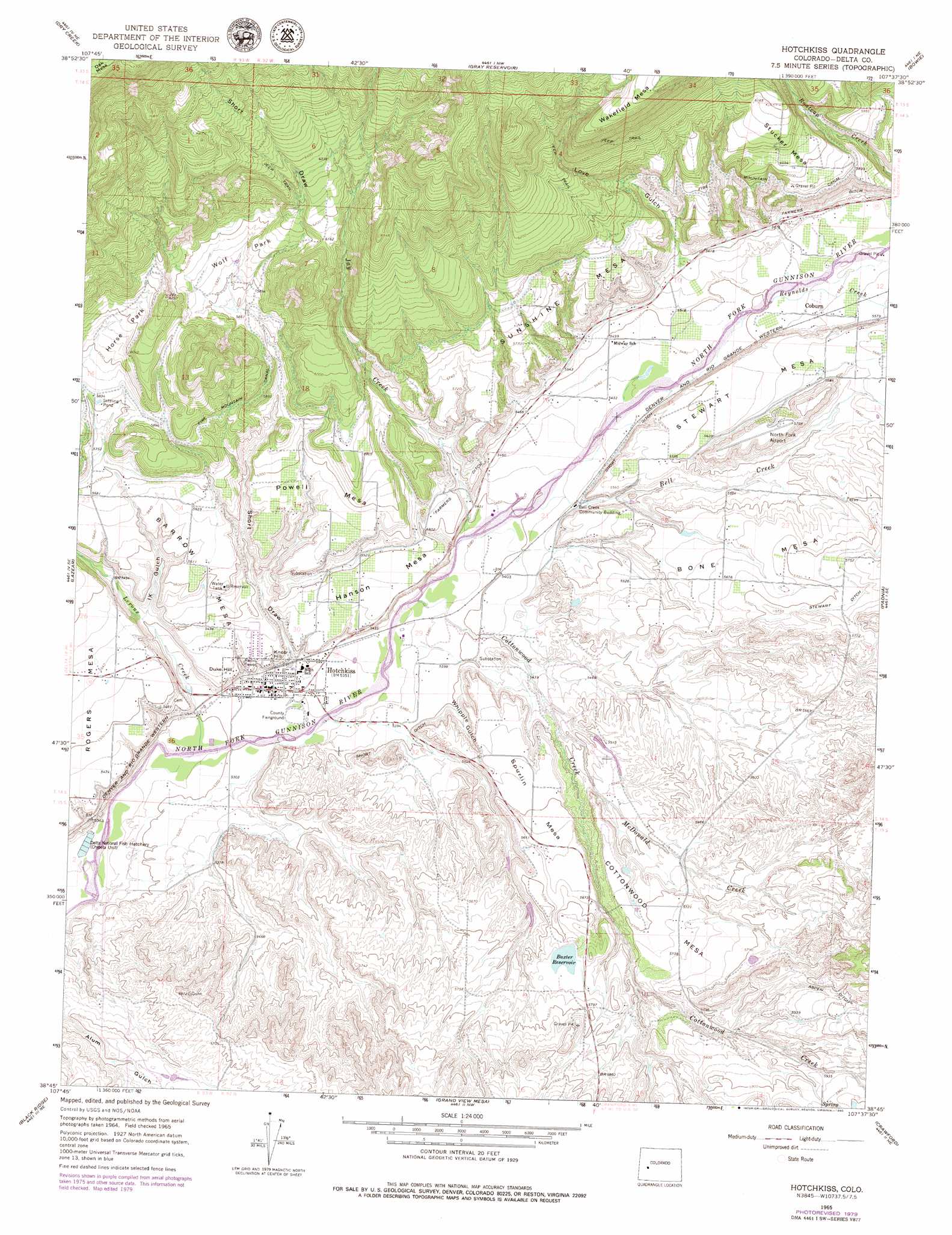
USGS Topo Quad 38107g6 - 1:24,000 scale
| Topo Map Name: | Hotchkiss |
| USGS Topo Quad ID: | 38107g6 |
| Print Size: | ca. 21 1/4" wide x 27" high |
| Southeast Coordinates: | 38.75° N latitude / 107.625° W longitude |
| Map Center Coordinates: | 38.8125° N latitude / 107.6875° W longitude |
| U.S. State: | CO |
| Filename: | o38107g6.jpg |
| Download Map JPG Image: | Hotchkiss topo map 1:24,000 scale |
| Map Type: | Topographic |
| Topo Series: | 7.5´ |
| Map Scale: | 1:24,000 |
| Source of Map Images: | United States Geological Survey (USGS) |
| Alternate Map Versions: |
Hotchkiss CO 1965, updated 1969 Download PDF Buy paper map Hotchkiss CO 1965, updated 1969 Download PDF Buy paper map Hotchkiss CO 1965, updated 1980 Download PDF Buy paper map Hotchkiss CO 1967, updated 1978 Download PDF Buy paper map Hotchkiss CO 2010 Download PDF Buy paper map Hotchkiss CO 2013 Download PDF Buy paper map Hotchkiss CO 2016 Download PDF Buy paper map |
1:24,000 Topo Quads surrounding Hotchkiss
Grand Mesa |
Leon Peak |
Chalk Mountain |
Electric Mountain |
Bull Mountain |
Cedaredge |
Dry Creek |
Gray Reservoir |
Bowie |
Somerset |
Orchard City |
Lazear |
Hotchkiss |
Paonia |
Minnesota Pass |
Olathe Nw |
Black Ridge |
Grand View Mesa |
Crawford |
Mount Guero |
Olathe |
Red Rock Canyon |
Grizzly Ridge |
Cathedral Peak |
X Lazy F Ranch |
> Back to 38107e1 at 1:100,000 scale
> Back to 38106a1 at 1:250,000 scale
> Back to U.S. Topo Maps home
Hotchkiss topo map: Gazetteer
Hotchkiss: Airports
North Fork Airport elevation 1766m 5793′North Fork Valley Airport elevation 1767m 5797′
Hotchkiss: Canals
Aspen Ditch elevation 1823m 5980′Farmers Ditch elevation 1718m 5636′
Fire Mountain Canal elevation 1802m 5912′
Short Ditch elevation 1668m 5472′
Hotchkiss: Dams
Baxter Dam elevation 1753m 5751′Hotchkiss: Flats
Horse Park elevation 1824m 5984′Wolf Park elevation 1807m 5928′
Hotchkiss: Mines
North Fork Pit elevation 1637m 5370′Hotchkiss: Parks
Delta National Fish Hatchery elevation 1600m 5249′Hotchkiss: Populated Places
Coburn elevation 1690m 5544′Hotchkiss elevation 1625m 5331′
Hotchkiss: Post Offices
Hotchkiss Post Office elevation 1622m 5321′Hotchkiss: Reservoirs
Baxter Reservoir elevation 1753m 5751′Hotchkiss: Streams
Bell Creek elevation 1647m 5403′Cottonwood Creek elevation 1635m 5364′
Jay Creek elevation 1654m 5426′
Leroux Creek elevation 1609m 5278′
McDonald Creek elevation 1663m 5456′
Reynolds Creek elevation 1678m 5505′
Hotchkiss: Summits
Barrow Mesa elevation 1716m 5629′Cottonwood Mesa elevation 1744m 5721′
Duke Hill elevation 1660m 5446′
Hanson Mesa elevation 1671m 5482′
Knob Hill elevation 1659m 5442′
Powell Mesa elevation 1726m 5662′
Spurlin Mesa elevation 1708m 5603′
Stucker Mesa elevation 1858m 6095′
Sunshine Mesa elevation 1754m 5754′
Hotchkiss: Valleys
I X Gulch elevation 1654m 5426′Love Gulch elevation 1707m 5600′
Shart Draw elevation 1635m 5364′
Whipple Gulch elevation 1647m 5403′
Hotchkiss digital topo map on disk
Buy this Hotchkiss topo map showing relief, roads, GPS coordinates and other geographical features, as a high-resolution digital map file on DVD: