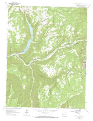
Paonia Reservoir Topo Map Colorado
To zoom in, hover over the map of Paonia Reservoir
USGS Topo Quad 38107h3 - 1:24,000 scale
| Topo Map Name: | Paonia Reservoir |
| USGS Topo Quad ID: | 38107h3 |
| Print Size: | ca. 21 1/4" wide x 27" high |
| Southeast Coordinates: | 38.875° N latitude / 107.25° W longitude |
| Map Center Coordinates: | 38.9375° N latitude / 107.3125° W longitude |
| U.S. State: | CO |
| Filename: | o38107h3.jpg |
| Download Map JPG Image: | Paonia Reservoir topo map 1:24,000 scale |
| Map Type: | Topographic |
| Topo Series: | 7.5´ |
| Map Scale: | 1:24,000 |
| Source of Map Images: | United States Geological Survey (USGS) |
| Alternate Map Versions: |
Paonia Reservoir CO 1964, updated 1967 Download PDF Buy paper map Paonia Reservoir CO 1964, updated 1967 Download PDF Buy paper map Paonia Reservoir CO 1964, updated 1984 Download PDF Buy paper map Paonia Reservoir CO 2001, updated 2004 Download PDF Buy paper map Paonia Reservoir CO 2011 Download PDF Buy paper map Paonia Reservoir CO 2013 Download PDF Buy paper map Paonia Reservoir CO 2016 Download PDF Buy paper map |
| FStopo: | US Forest Service topo Paonia Reservoir is available: Download FStopo PDF Download FStopo TIF |
1:24,000 Topo Quads surrounding Paonia Reservoir
> Back to 38107e1 at 1:100,000 scale
> Back to 38106a1 at 1:250,000 scale
> Back to U.S. Topo Maps home
Paonia Reservoir topo map: Gazetteer
Paonia Reservoir: Canals
Elkhorn Stomp Ditch elevation 2447m 8028′Fillmore Ditch elevation 2427m 7962′
Norris Ditch elevation 2437m 7995′
Twin Forks Ditch elevation 2427m 7962′
Paonia Reservoir: Dams
Paonia Dam elevation 1967m 6453′Paonia Reservoir: Flats
Watson Flats elevation 2309m 7575′Paonia Reservoir: Lakes
Williams Creek Lake elevation 2491m 8172′Paonia Reservoir: Parks
Paonia Reservoir State Recreation Area elevation 1967m 6453′Paonia Reservoir: Reservoirs
Paonia Reservoir elevation 1967m 6453′Paonia Reservoir: Springs
Erickson Springs elevation 2071m 6794′Erickson Springs elevation 2062m 6765′
Paonia Reservoir: Streams
Anthracite Creek elevation 1910m 6266′Coal Creek elevation 1939m 6361′
Cottonwood Creek elevation 1901m 6236′
Deep Creek elevation 1968m 6456′
Dry Fork Snowshoe Creek elevation 2049m 6722′
Dugout Creek elevation 1975m 6479′
East Muddy Creek elevation 1995m 6545′
Grouse Spring Creek elevation 2236m 7335′
Muddy Creek elevation 1975m 6479′
Muddy Fork elevation 2053m 6735′
Munsey Creek elevation 2067m 6781′
Schaefer Creek elevation 2222m 7290′
Snowshoe Creek elevation 1945m 6381′
South Snowshoe Creek elevation 2171m 7122′
Vogel Creek elevation 2213m 7260′
West Muddy Creek elevation 1990m 6528′
Williams Creek elevation 1966m 6450′
Paonia Reservoir: Summits
Goose Hill elevation 2425m 7956′Raven Mesa elevation 2524m 8280′
The Pines elevation 2560m 8398′
Paonia Reservoir: Valleys
Coyote Gulch elevation 2013m 6604′Dark Canyon elevation 1910m 6266′
Layton Gulch elevation 2037m 6683′
Snowshoe Canyon elevation 1947m 6387′
Paonia Reservoir digital topo map on disk
Buy this Paonia Reservoir topo map showing relief, roads, GPS coordinates and other geographical features, as a high-resolution digital map file on DVD:


