Somerset Topo Map Colorado
To zoom in, hover over the map of Somerset
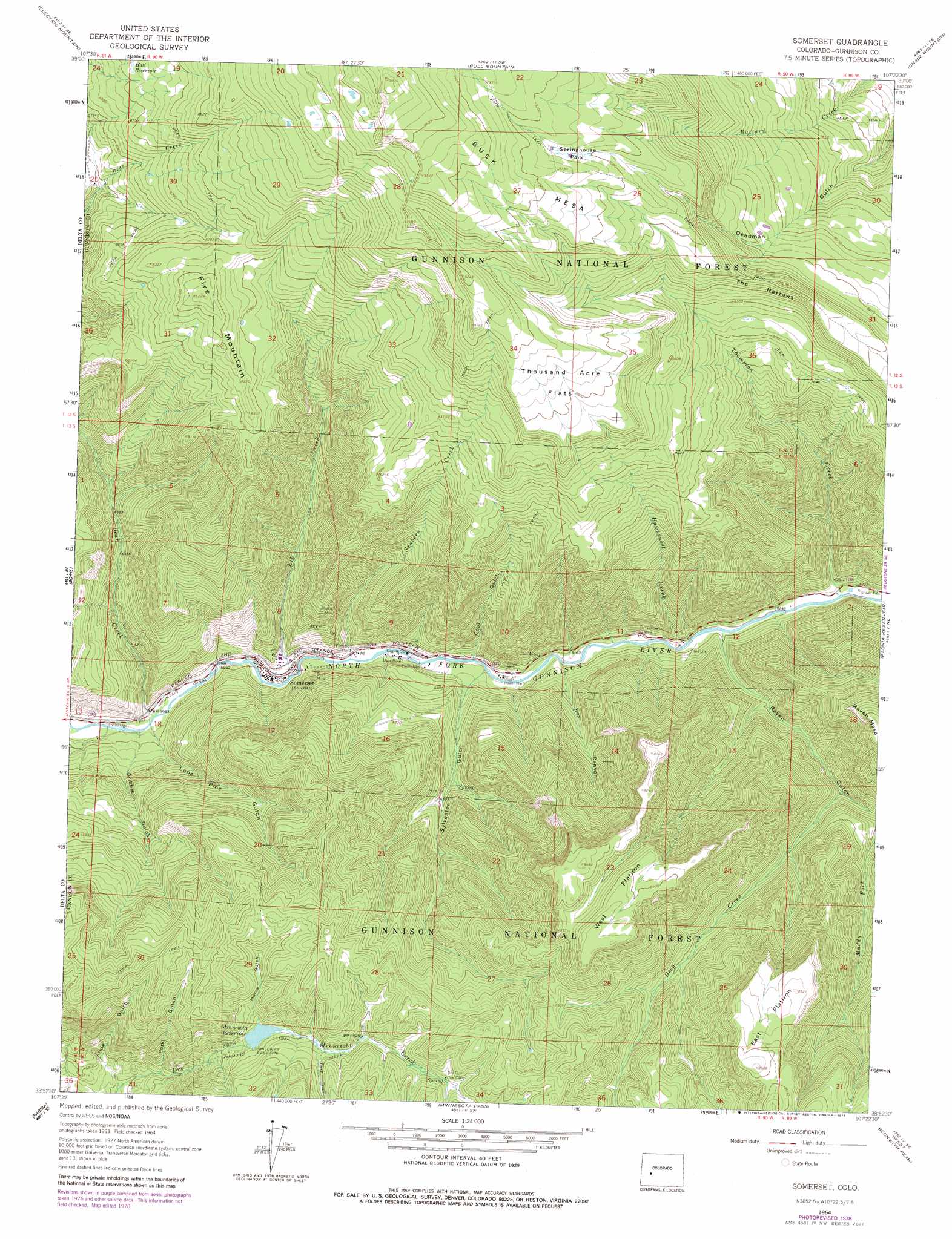
USGS Topo Quad 38107h4 - 1:24,000 scale
| Topo Map Name: | Somerset |
| USGS Topo Quad ID: | 38107h4 |
| Print Size: | ca. 21 1/4" wide x 27" high |
| Southeast Coordinates: | 38.875° N latitude / 107.375° W longitude |
| Map Center Coordinates: | 38.9375° N latitude / 107.4375° W longitude |
| U.S. State: | CO |
| Filename: | o38107h4.jpg |
| Download Map JPG Image: | Somerset topo map 1:24,000 scale |
| Map Type: | Topographic |
| Topo Series: | 7.5´ |
| Map Scale: | 1:24,000 |
| Source of Map Images: | United States Geological Survey (USGS) |
| Alternate Map Versions: |
Somerset CO 1964, updated 1967 Download PDF Buy paper map Somerset CO 1964, updated 1967 Download PDF Buy paper map Somerset CO 1964, updated 1979 Download PDF Buy paper map Somerset CO 2001, updated 2004 Download PDF Buy paper map Somerset CO 2011 Download PDF Buy paper map Somerset CO 2013 Download PDF Buy paper map Somerset CO 2016 Download PDF Buy paper map |
| FStopo: | US Forest Service topo Somerset is available: Download FStopo PDF Download FStopo TIF |
1:24,000 Topo Quads surrounding Somerset
Porter Mountain |
Spruce Mountain |
Elk Knob |
Placita |
Redstone |
Chalk Mountain |
Electric Mountain |
Bull Mountain |
Chair Mountain |
Marble |
Gray Reservoir |
Bowie |
Somerset |
Paonia Reservoir |
Marcellina Mountain |
Hotchkiss |
Paonia |
Minnesota Pass |
West Beckwith Mountain |
Anthracite Range |
Grand View Mesa |
Crawford |
Mount Guero |
Big Soap Park |
West Elk Peak |
> Back to 38107e1 at 1:100,000 scale
> Back to 38106a1 at 1:250,000 scale
> Back to U.S. Topo Maps home
Somerset topo map: Gazetteer
Somerset: Dams
Monument Dam elevation 2228m 7309′Somerset: Flats
Springhouse Park elevation 2755m 9038′Thousand Acre Flats elevation 2703m 8868′
Somerset: Mines
Axelson Mine elevation 1894m 6213′Bear Mine elevation 1852m 6076′
Clark Mine elevation 1872m 6141′
Hawksnest Mine elevation 1890m 6200′
Hubbard Mine elevation 1928m 6325′
Kaiser Mine elevation 1871m 6138′
Mount Gunnison Number One Mine elevation 2026m 6646′
O.C. Mine Number Two elevation 1977m 6486′
Oliver Mine elevation 1872m 6141′
Paonia Coal Drilling Project Mine elevation 2343m 7687′
Somerset B Seam and C Seam Mine elevation 1863m 6112′
Somerset Mine elevation 1977m 6486′
Somerset: Populated Places
Somerset elevation 1838m 6030′Somerset: Post Offices
Somerset Post Office elevation 1841m 6040′Somerset: Reservoirs
Hall Reservoir elevation 2507m 8225′Minnesota Reservoir elevation 2234m 7329′
Monument Reservoir elevation 2228m 7309′
Somerset: Ridges
The Narrows elevation 2614m 8576′Somerset: Streams
Bear Creek elevation 1808m 5931′Deep Creek elevation 2013m 6604′
Deer Creek elevation 2299m 7542′
Elk Creek elevation 1829m 6000′
Hawksnest Creek elevation 1879m 6164′
Sanborn Creek elevation 1838m 6030′
Spring Creek elevation 2435m 7988′
Thompson Creek elevation 1898m 6227′
Somerset: Summits
Buck Mesa elevation 2990m 9809′East Flatiron elevation 2589m 8494′
Fire Mountain elevation 2599m 8526′
West Flatiron elevation 2583m 8474′
Somerset: Valleys
Box Canyon elevation 1892m 6207′Coal Gulch elevation 1879m 6164′
Gribble Gulch elevation 1820m 5971′
Horse Gulch elevation 2236m 7335′
Lone Pine Gulch elevation 1818m 5964′
Pond Gulch elevation 2064m 6771′
Raven Gulch elevation 1889m 6197′
Slide Gulch elevation 2004m 6574′
Sylvester Gulch elevation 1890m 6200′
Somerset digital topo map on disk
Buy this Somerset topo map showing relief, roads, GPS coordinates and other geographical features, as a high-resolution digital map file on DVD: