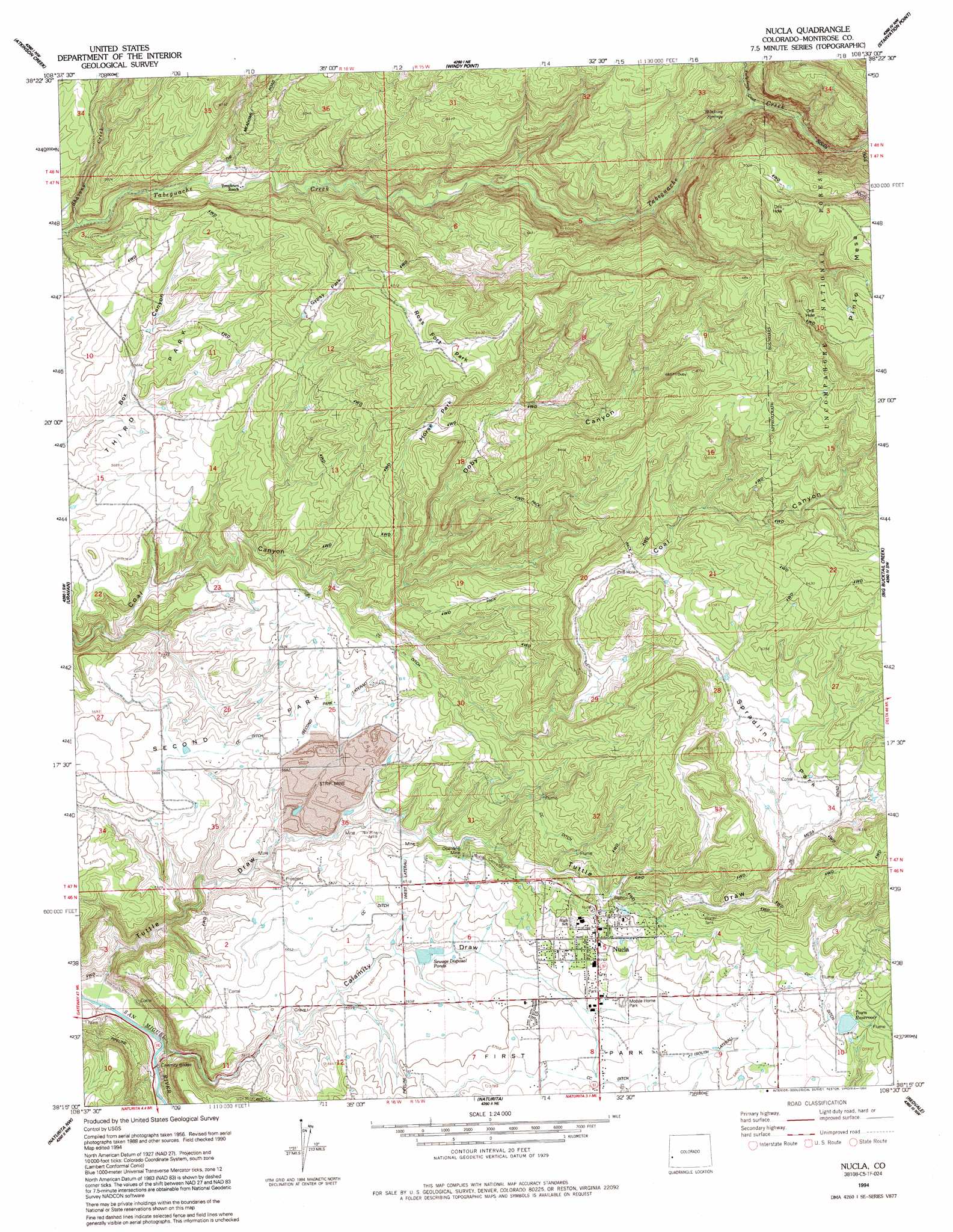
Nucla Topo Map Colorado
To zoom in, hover over the map of Nucla
USGS Topo Quad 38108c5 - 1:24,000 scale
| Topo Map Name: | Nucla |
| USGS Topo Quad ID: | 38108c5 |
| Print Size: | ca. 21 1/4" wide x 27" high |
| Southeast Coordinates: | 38.25° N latitude / 108.5° W longitude |
| Map Center Coordinates: | 38.3125° N latitude / 108.5625° W longitude |
| U.S. State: | CO |
| Filename: | o38108c5.jpg |
| Download Map JPG Image: | Nucla topo map 1:24,000 scale |
| Map Type: | Topographic |
| Topo Series: | 7.5´ |
| Map Scale: | 1:24,000 |
| Source of Map Images: | United States Geological Survey (USGS) |
| Alternate Map Versions: |
Nucla CO 1960, updated 1961 Download PDF Buy paper map Nucla CO 1960, updated 1961 Download PDF Buy paper map Nucla CO 1960, updated 1985 Download PDF Buy paper map Nucla CO 1994, updated 1994 Download PDF Buy paper map Nucla CO 2011 Download PDF Buy paper map Nucla CO 2013 Download PDF Buy paper map Nucla CO 2016 Download PDF Buy paper map |
| FStopo: | US Forest Service topo Nucla is available: Download FStopo PDF Download FStopo TIF |
1:24,000 Topo Quads surrounding Nucla
Calamity Mesa |
Uncompahgre Butte |
Snipe Mountain |
Kelso Point |
Cottonwood Basin |
Red Canyon |
Atkinson Creek |
Windy Point |
Starvation Point |
Moore Mesa |
Davis Mesa |
Uravan |
Nucla |
Big Bucktail Creek |
Ute |
Bull Canyon |
Naturita Nw |
Naturita |
Redvale |
Norwood |
Hamm Canyon |
Gypsum Gap |
Basin |
Barkelew Draw |
Oak Hill |
> Back to 38108a1 at 1:100,000 scale
> Back to 38108a1 at 1:250,000 scale
> Back to U.S. Topo Maps home
Nucla topo map: Gazetteer
Nucla: Canals
C C Ditch - Second Park Lateral elevation 1749m 5738′C C Ditch - South Lateral elevation 1750m 5741′
C C Ditch - West Lateral elevation 1750m 5741′
Nucla: Dams
Nucla Domestic Dam elevation 1806m 5925′Nucla: Flats
Gypsy Park elevation 1847m 6059′Horse Park elevation 1858m 6095′
Ross Fort Park elevation 1917m 6289′
Second Park elevation 1703m 5587′
Spradlin Park elevation 1861m 6105′
Nucla: Mines
Cottonwood Mine elevation 1776m 5826′Farmer Boy Mine elevation 1789m 5869′
Navajo Mine elevation 1754m 5754′
Nix Mine elevation 1728m 5669′
Oberding Mine elevation 1753m 5751′
USV Mine elevation 1735m 5692′
Nucla: Populated Places
Nucla elevation 1764m 5787′Nucla: Reservoirs
Nucla Domestic Reservoir elevation 1806m 5925′Town Reservoir elevation 1802m 5912′
Nucla: Springs
Stinking Springs elevation 1823m 5980′Nucla: Streams
Forty-seven Creek elevation 1816m 5958′Shavano Creek elevation 1676m 5498′
Nucla: Valleys
Calamity Draw elevation 1607m 5272′Doby Canyon elevation 1750m 5741′
Tuttle Draw elevation 1595m 5232′
Nucla digital topo map on disk
Buy this Nucla topo map showing relief, roads, GPS coordinates and other geographical features, as a high-resolution digital map file on DVD: