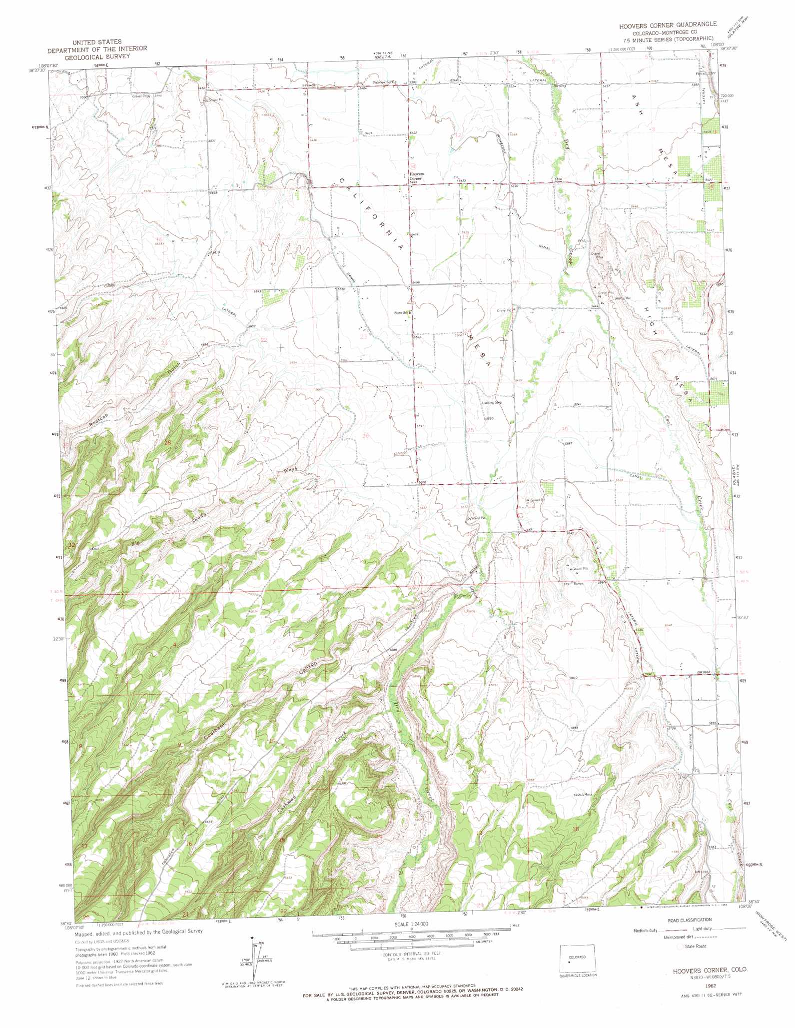
Hoovers Corner Topo Map Colorado
To zoom in, hover over the map of Hoovers Corner
USGS Topo Quad 38108e1 - 1:24,000 scale
| Topo Map Name: | Hoovers Corner |
| USGS Topo Quad ID: | 38108e1 |
| Print Size: | ca. 21 1/4" wide x 27" high |
| Southeast Coordinates: | 38.5° N latitude / 108° W longitude |
| Map Center Coordinates: | 38.5625° N latitude / 108.0625° W longitude |
| U.S. State: | CO |
| Filename: | o38108e1.jpg |
| Download Map JPG Image: | Hoovers Corner topo map 1:24,000 scale |
| Map Type: | Topographic |
| Topo Series: | 7.5´ |
| Map Scale: | 1:24,000 |
| Source of Map Images: | United States Geological Survey (USGS) |
| Alternate Map Versions: |
Hoovers Corner CO 1962, updated 1966 Download PDF Buy paper map Hoovers Corner CO 2010 Download PDF Buy paper map Hoovers Corner CO 2013 Download PDF Buy paper map Hoovers Corner CO 2016 Download PDF Buy paper map |
1:24,000 Topo Quads surrounding Hoovers Corner
Dominguez |
Point Creek |
North Delta |
Orchard City |
Lazear |
Good Point |
Roubideau |
Delta |
Olathe Nw |
Black Ridge |
Cottonwood Basin |
Camel Back |
Hoovers Corner |
Olathe |
Red Rock Canyon |
Moore Mesa |
Davis Point |
Dry Creek Basin |
Montrose West |
Montrose East |
Ute |
Antone Spring |
Pryor Creek |
Government Springs |
Colona |
> Back to 38108e1 at 1:100,000 scale
> Back to 38108a1 at 1:250,000 scale
> Back to U.S. Topo Maps home
Hoovers Corner topo map: Gazetteer
Hoovers Corner: Canals
C Canal elevation 1687m 5534′C P Lateral elevation 1721m 5646′
C Q A Lateral elevation 1734m 5688′
C Q Lateral elevation 1732m 5682′
Hoovers Corner: Dams
Roatcap Wash Watershed RW-1 Dam elevation 1737m 5698′Hoovers Corner: Populated Places
Hoovers Corner elevation 1661m 5449′Hoovers Corner: Reservoirs
Roatcap Wash Watershed RW-1 Reservoir elevation 1737m 5698′Hoovers Corner: Streams
Big Sandy Wash elevation 1678m 5505′Coal Creek elevation 1651m 5416′
Cushman Creek elevation 1732m 5682′
Hoovers Corner: Summits
Ash Mesa elevation 1669m 5475′California Mesa elevation 1708m 5603′
Hoovers Corner: Valleys
Coalbank Canyon elevation 1712m 5616′East Fork Roatcap Gulch elevation 1788m 5866′
Roatcap Gulch elevation 1705m 5593′
Shavano Valley elevation 1745m 5725′
Hoovers Corner digital topo map on disk
Buy this Hoovers Corner topo map showing relief, roads, GPS coordinates and other geographical features, as a high-resolution digital map file on DVD: