Snipe Mountain Topo Map Colorado
To zoom in, hover over the map of Snipe Mountain
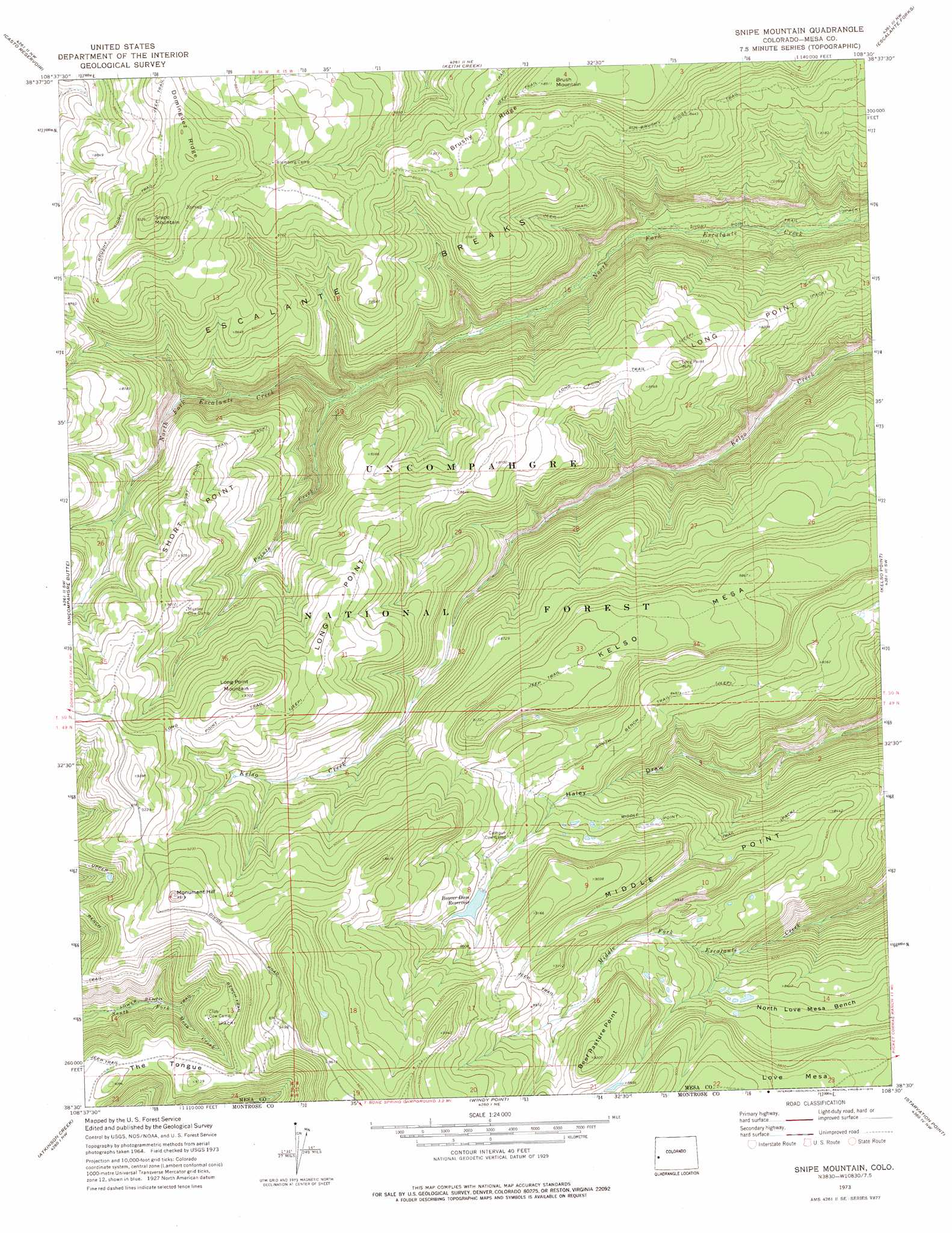
USGS Topo Quad 38108e5 - 1:24,000 scale
| Topo Map Name: | Snipe Mountain |
| USGS Topo Quad ID: | 38108e5 |
| Print Size: | ca. 21 1/4" wide x 27" high |
| Southeast Coordinates: | 38.5° N latitude / 108.5° W longitude |
| Map Center Coordinates: | 38.5625° N latitude / 108.5625° W longitude |
| U.S. State: | CO |
| Filename: | o38108e5.jpg |
| Download Map JPG Image: | Snipe Mountain topo map 1:24,000 scale |
| Map Type: | Topographic |
| Topo Series: | 7.5´ |
| Map Scale: | 1:24,000 |
| Source of Map Images: | United States Geological Survey (USGS) |
| Alternate Map Versions: |
Snipe Mountain CO 1973, updated 1975 Download PDF Buy paper map Snipe Mountain CO 1973, updated 1975 Download PDF Buy paper map Snipe Mountain CO 2011 Download PDF Buy paper map Snipe Mountain CO 2013 Download PDF Buy paper map Snipe Mountain CO 2016 Download PDF Buy paper map |
| FStopo: | US Forest Service topo Snipe Mountain is available: Download FStopo PDF Download FStopo TIF |
1:24,000 Topo Quads surrounding Snipe Mountain
Fish Creek |
Snyder Flats |
Jacks Canyon |
Triangle Mesa |
Dominguez |
Pine Mountain |
Casto Reservoir |
Keith Creek |
Escalante Forks |
Good Point |
Calamity Mesa |
Uncompahgre Butte |
Snipe Mountain |
Kelso Point |
Cottonwood Basin |
Red Canyon |
Atkinson Creek |
Windy Point |
Starvation Point |
Moore Mesa |
Davis Mesa |
Uravan |
Nucla |
Big Bucktail Creek |
Ute |
> Back to 38108e1 at 1:100,000 scale
> Back to 38108a1 at 1:250,000 scale
> Back to U.S. Topo Maps home
Snipe Mountain topo map: Gazetteer
Snipe Mountain: Cliffs
Long Point elevation 2725m 8940′Short Point elevation 2682m 8799′
Snipe Mountain: Dams
Beaver-Huffington Dam elevation 2700m 8858′Snipe Mountain: Reservoirs
Beaver Dam Reservoir elevation 2673m 8769′Beaver-Huffington Reservoir elevation 2700m 8858′
Snipe Mountain: Ridges
Middle Point elevation 2494m 8182′Snipe Mountain: Streams
Points Creek elevation 2354m 7723′Snipe Mountain: Summits
Beef Pasture Point elevation 2807m 9209′Brush Mountain elevation 2715m 8907′
Kelso Mesa elevation 2796m 9173′
Long Point Mountain elevation 2856m 9370′
Love Mesa elevation 2764m 9068′
Monument Hill elevation 2898m 9507′
Snipe Mountain elevation 2844m 9330′
Snipe Mountain: Trails
Bench Trail elevation 2730m 8956′Brushy Ridge Trail elevation 2595m 8513′
Long Point Trail elevation 2517m 8257′
Short Point Trail elevation 2235m 7332′
Snipe Mountain digital topo map on disk
Buy this Snipe Mountain topo map showing relief, roads, GPS coordinates and other geographical features, as a high-resolution digital map file on DVD: