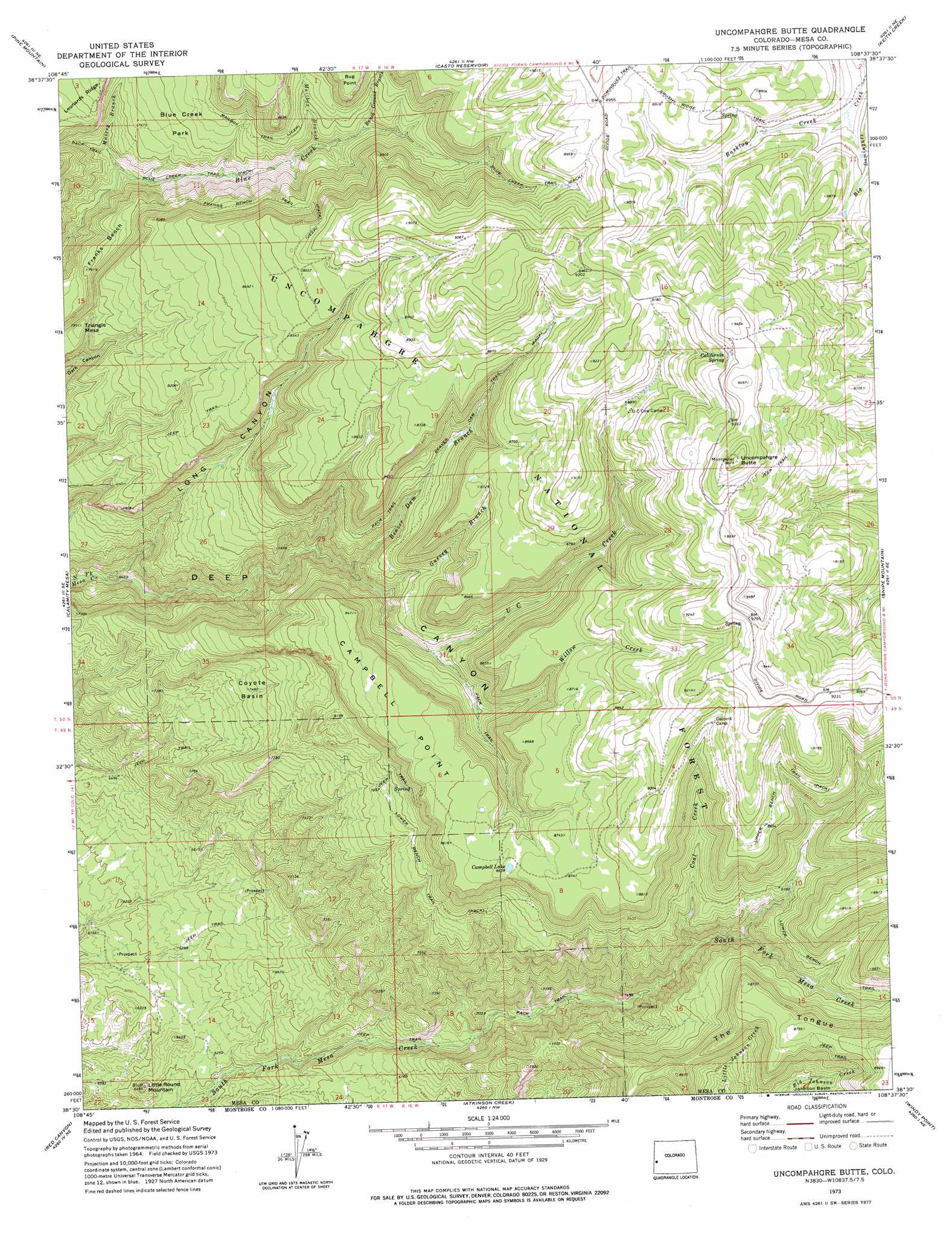
Uncompahgre Butte Topo Map Colorado
To zoom in, hover over the map of Uncompahgre Butte
USGS Topo Quad 38108e6 - 1:24,000 scale
| Topo Map Name: | Uncompahgre Butte |
| USGS Topo Quad ID: | 38108e6 |
| Print Size: | ca. 21 1/4" wide x 27" high |
| Southeast Coordinates: | 38.5° N latitude / 108.625° W longitude |
| Map Center Coordinates: | 38.5625° N latitude / 108.6875° W longitude |
| U.S. State: | CO |
| Filename: | o38108e6.jpg |
| Download Map JPG Image: | Uncompahgre Butte topo map 1:24,000 scale |
| Map Type: | Topographic |
| Topo Series: | 7.5´ |
| Map Scale: | 1:24,000 |
| Source of Map Images: | United States Geological Survey (USGS) |
| Alternate Map Versions: |
Uncompahgre Butte CO 1973, updated 1976 Download PDF Buy paper map Uncompahgre Butte CO 2011 Download PDF Buy paper map Uncompahgre Butte CO 2013 Download PDF Buy paper map Uncompahgre Butte CO 2016 Download PDF Buy paper map |
| FStopo: | US Forest Service topo Uncompahgre Butte is available: Download FStopo PDF Download FStopo TIF |
1:24,000 Topo Quads surrounding Uncompahgre Butte
Two V Basin |
Fish Creek |
Snyder Flats |
Jacks Canyon |
Triangle Mesa |
Gateway |
Pine Mountain |
Casto Reservoir |
Keith Creek |
Escalante Forks |
Juanita Arch |
Calamity Mesa |
Uncompahgre Butte |
Snipe Mountain |
Kelso Point |
Roc Creek |
Red Canyon |
Atkinson Creek |
Windy Point |
Starvation Point |
Paradox |
Davis Mesa |
Uravan |
Nucla |
Big Bucktail Creek |
> Back to 38108e1 at 1:100,000 scale
> Back to 38108a1 at 1:250,000 scale
> Back to U.S. Topo Maps home
Uncompahgre Butte topo map: Gazetteer
Uncompahgre Butte: Basins
Coyote Basin elevation 2283m 7490′Johnson Basin elevation 2508m 8228′
Uncompahgre Butte: Benches
Franks Bench elevation 2332m 7650′Uncompahgre Butte: Flats
Blue Creek Park elevation 2380m 7808′Uncompahgre Butte: Lakes
Campbell Lake elevation 2643m 8671′Uncompahgre Butte: Mines
Truck Stop Placer elevation 1908m 6259′Uncompahgre Butte: Ridges
The Tongue elevation 2640m 8661′Uncompahgre Butte: Springs
California Spring elevation 2838m 9311′Uncompahgre Butte: Streams
Barklay Creek elevation 2593m 8507′Beaver Dam Branch North Fork Mesa Creek elevation 2290m 7513′
Bunch Ground Branch Blue Creek elevation 2400m 7874′
Coal Creek elevation 2288m 7506′
Garvey Branch elevation 2340m 7677′
Mailbox Branch Blue Creek elevation 2357m 7732′
Massey Branch elevation 2208m 7244′
U C Creek elevation 2394m 7854′
Willow Creek elevation 2434m 7985′
Uncompahgre Butte: Summits
Campbell Point elevation 2686m 8812′Little Round Mountain elevation 1982m 6502′
Triangle Mesa elevation 2423m 7949′
Uncompahgre Butte elevation 2945m 9662′
Uncompahgre Butte: Trails
Beaver Dam Trail elevation 2522m 8274′Blue Creek Trail elevation 2415m 7923′
Franks Bench Trail elevation 2487m 8159′
Lower Bench Trail elevation 2499m 8198′
Mailbox Trail elevation 2452m 8044′
Upper Bench Trail elevation 2662m 8733′
Uncompahgre Butte: Valleys
Deep Canyon elevation 2081m 6827′Long Canyon elevation 1985m 6512′
Uncompahgre Butte digital topo map on disk
Buy this Uncompahgre Butte topo map showing relief, roads, GPS coordinates and other geographical features, as a high-resolution digital map file on DVD: